ABOUT THE PARK:
DIRECTIONS:
GPS Coordinates 42.23835, -74.11638
 |
| Parking in the lot at the trail head at the sign, above, not at the Colgate Lake Access Parking which is a larger lot that is passed on the way to this one. |
TRAIL MAP
HIKE DISTANCE: 12.6 miles (6.3 miles each way)
THE HIKE:
This is not one of the popular Catskill hikes because Arizona Mountain is just 100 feet shy of making the Catskill 3500 list so it is overlooked. Hiking this on an incredibly busy holiday weekend, I ran into nobody until the last mile of the hike.
 |
| The trail starts either to the left or right of the gate. |
 |
| Left goes through woods briefly then turns right into the meadow. |
 |
| A kiosk and trail register just after entering the woods. |
 |
| For the first three miles the trail is relative flat, sometimes smooth, sometimes rocky. There are spots that are always muddy except for now. In this drought everything is dry. |
 |
| The trail was clear and well-marked. |
 |
| There are four bridges to cross, the third being more of a boardwalk. |
 |
| Sunny spots were a bit overgrown but still very passable. |
 |
| A nice view of where we were heading on the left. |
 |
| There is supposed to be an arched bridge but there wasn't. I am thinking that was old information and might have been here where there are old bridge abutments. |
 |
| Dutcher Notch Falls - completely dry. |
 |
| The trail begins to ascend a little more steeply nearing Dutcher Notch. |
 |
| At Dutcher Notch the Escarpment Trail crosses over. |
 |
| We turned left on the blue Long Path/Escarpment Trail. |
 |
| This begins to ascend more steeply. |
 |
| I had heard you have to go through this hole to stay on the trail. That is actually not true, the trail is a scramble up to the left of this hole. But the hole was more fun and easier. |
 |
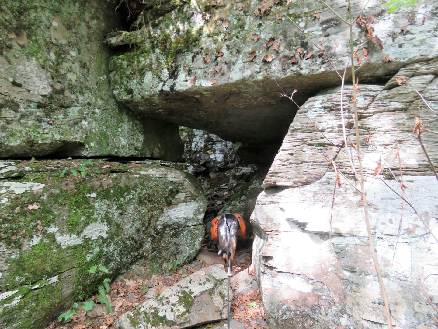
| Either way you come out at this notch that was too narrow for Brodie. I had to hold the saddlebags up for him to get through. |
 |
| The trail continues to ascend on some switchbacks. |
 |
| After the switchbacks the trail ascends steeply on loose dirt which is sometimes like walking on marbles. |
 |
| Seriously? |
 |
| I find these all the time which leads me to believe they must not work because nobody has the energy to pack out the empties. (Brodie on his way back for me to load it in his backpack. He knows the drill.) |
 |
| There are some rock scrambles the rest of the way up but nothing crazy. Brodie was able to do them all on his own. |
 |
| He does get a little impatient waiting for me. He doesn't understand that I don't have four paw drive like he does. |
 |
| Just after the trail levels out and comes to a T-intersection ... |
 |
| ... outstanding views to the left. |
 |
| The pictures don't do the views justice at all. |
 |
| Continuing on to the next overlook. |
 |
| This one was pretty disappointing so on to the next one. |
 |
| The trail is now fairly level with some minor ups and downs. |
 |
| The third overlook was nowhere to be found unless it was meant to be the view of Blackhead Mountain straight ahead. |
 |
| On the overlook #4 which would be just before the ascent up Blackhead. |
 |
| And here it is, a view of the Hudson Valley. |
 |
| Zooming in to the Hudson River in the distance. |
 |
| It was at this point we turned back and I could just kick myself for not continuing on to summit Blackhead. It was only half a mile away but I just did not have another uphill climb in me. That will teach me to do a leg intensive workout the day before. |
 |
| Stopping back at the first overlook for a long break before beginning the descent. |
 |
| Back at that notch, now having to go down into it, Brodie flat out refused so I had to hold the saddlebags up while stuffing him and four flailing legs down into it while straddling that gap. Thankfully there were no witnesses to this. |
 |
| He made it and lived to tell about it. |
 |
| Back at Dutchers Notch, right on yellow. |
 |
| Looking back at the ridge where we had just been. |
 |
| A tiny bit of running water where I let Brodie drink. He only drinks what he absolutely has to from the water I haul along for him but he would stand and drink that delicious creek water forever. |
 |
| Back at the trail register to sign out. Four other people had signed in after us going to the notch and back so that must have happened while we were on Arizona because I never saw them. |
 |
| Heading back into the meadow ... |
 |
| ... coming out on the other side of that gate at the parking lot. |
Flowers were scarce if I saw any on recent hikes but this area had some fall wildflowers surviving the drought.


No comments:
Post a Comment