Saturday, July 31, 2021

Nancy Conger West Brook Preserve, NJ

ABOUT THE PARK: 
Nancy Conger West Brook Preserve - The Land Conservancy of New Jersey

DIRECTIONS: 
GPS Coordinates 41.08665, -74.37466
Parking lot off of Westbrook Road.
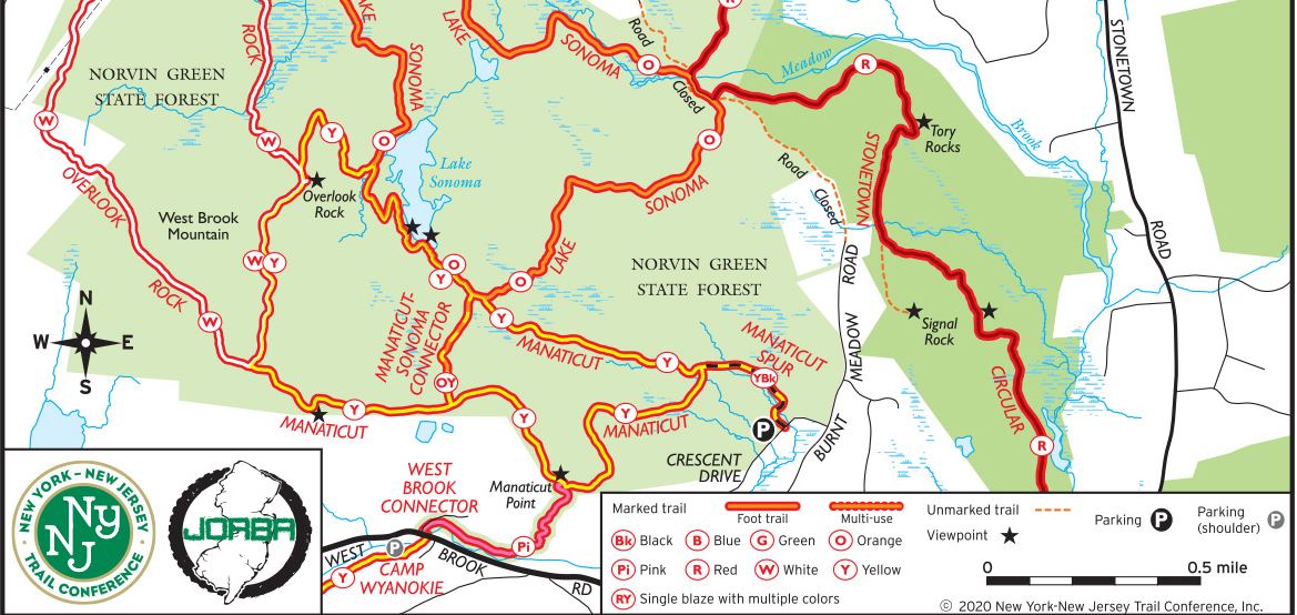
TRAIL MAP: 
No map online.

HIKE DISTANCE: 1.8 miles
Hiked together with Norvin Green State Forest, NJ - Camp Wyanokie and Manaticut Point Loop - 8.1 miles (2.3 miles away)

THE HIKE: 
A footbridge over...
West Brook
The trail climbs up the rocky slope ...
... all the way to the top.
It follows the ridge then descends ...
... completing the loop portion and crossing West Brook to retrace back.

Norvin Green State Forest, NJ - Camp Wyanokie and Manaticut Point Loop

ABOUT THE PARKS: 
Norvin Green State Forest - New Jersey State Park Service

DIRECTIONS: 
GPS Coordinates 41.07400, -74.34775
Parking along Snake Den Road.

TRAIL MAP: 
North Jersey Trails Map #115 - NY/NJ Trail Conference (Some blazing has changed since the 2017 version and will probably be updated when the 2021 version comes out.)
Camp Wyanokie Trail Map


HIKE DISTANCE: 8.1 miles
Hiked together with Nancy Conger West Brook Preserve, NJ (2.3 miles away) - 1.8 miles

THE HIKE: 
Turn right on Snake Den Road from the parking area and walk beyond where the gravel road becomes paved.
Left on the blue trail.
Boy Scout Lake
Just before the dam ...
... right on yellow.
At Westbrook Road ...
... turn left then ...
... right immediately after the bridge to the pink trail where it starts on the right just after the guardrail.
The pink trail follows along West Brook.
Where the pink trail turns left and starts uphill ...
... I found a blue trail marker on the ground.  This would have been where pink ended at blue but with the reblazing, it is now pink all the way up and blue has been eliminated.
Continuing on pink for the steep uphill section to Manaticut Point.
I thought this meant to the left up the rock face but turns out that is not the case, it is a left turn along the bottom of that rock slab.
Pink ends at the top (looking back at the beginning to note for the return) at ...
... Manaticut Point views of the New York City skyline and ...
... a quarry.
It was exactly 2 miles from Camp Wyanokie to Manaticut Point.
We turned left on yellow to loop around clockwise.
Yellow/orange would short cut the loop but you would miss Lake Sonoma
White joins in from the left.
Where the trail turns left, go right first through the cleft to ...
Overlook Rock
A huge mushroom (with Brodie for size comparison).
Along Lake Sonoma, orange joins in from the left.
Lake Sonoma
Doesn't look very seaworthy.
Passing the other end of orange/yellow.
Bear scat on the trail.
The connector trail to parking on Crescent Drive.
Around that tree heading back to Manaticut Point.
An old faded blue blaze of the former blue trail.  It is at this rock that to the left ...
... the pink trail starts.
Manaticut Point view on the way to the pink trail.
Descending steeply ...
... all the way to West Brook.
Coming back out on Westbrook Road ...
... to left across the bridge ...
... then right to yellow.
When yellow comes out at Boy Scout Lake ...
... right across the dam.
Left on Snake Den Road ...
... back to parking.