ABOUT THE PARK:
Shawangunk Ridge - Wikipedia
The Long Path - New York New Jersey Trail Conference
The Shawangunk Ridge Trail - SRT Run/Hike
DIRECTIONS:
GPS Coordinates 41.606240, -74.426607
.jpg) |
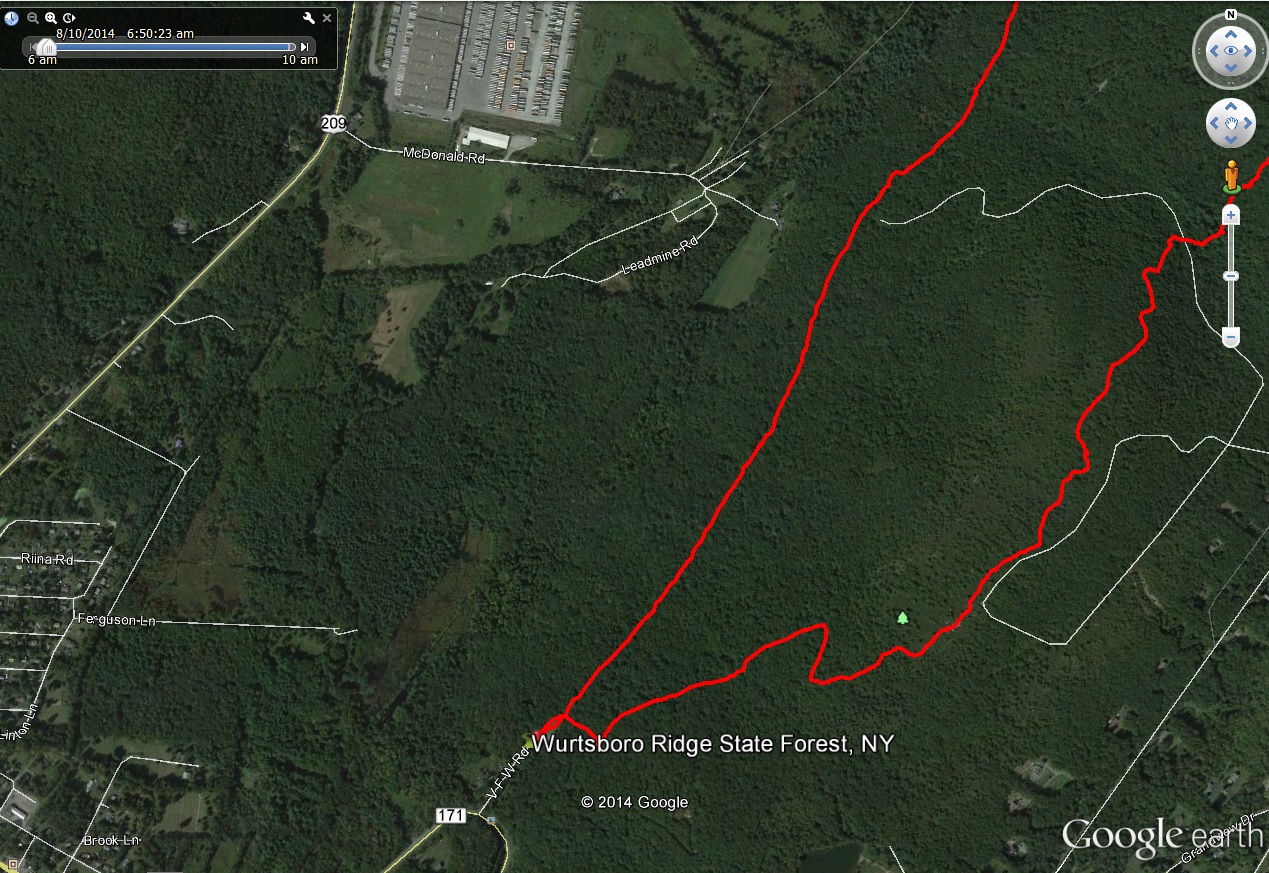
| Parking for this hike is in the Wurtsboro Ridge State Forest lot. |
TRAIL MAP:
Shawangunk Ridge Trail Map 3 - New York New Jersey Trail Conference
Roosa Gap State Forest Map - Andyarthur.org
HIKE DISTANCE: 6.8 miles
THE HIKE:
The ongoing fugitive manhunt in the forests of Pennsylvania, bear mauling in New Jersey, how about hiking in New York?
.jpg) |
| This sign was in the parking lot by the start of the yellow trail. It was 7:30 AM and 51 degrees so I figured the bees would still be asleep (they were) and we could road walk in lieu of the yellow trail on our return route, which is what we did. |
.jpg) |
| Just too inviting not to go so we tiptoed through and did not wake the bees up. |
.jpg)
.jpg) |
| There would normally be several creek crossings and waterfalls but everything was bone dry. |
.jpg)
.jpg) |
| Turn right at the Long Path/Shawangunk Ridge Trail intersection. |
.jpg) |
| Cross Ferguson Road and continue on the Long Path North. |
.jpg) |
| It's a steep, relentless climb up. |
.jpg) |
| Views south with low clouds in the valley early in the morning. |
.jpg)
.jpg)
.jpg) |
| Looking south to High Point Monument in NJ about 25 miles away. |
.jpg)
.jpg)
.jpg)
.jpg) |
| The Catskills start to come into view. |
.jpg) |
| A memorial at an intersection. The trail to the right goes to the fire tower, now used by the NY State Police, I believe, but I investigated that on the way back since in the morning the sun was blinding from that direction. |
.jpg) |
| Onward on the Long Path. |
.jpg)
.jpg) |
| Sam's Point |
.jpg) |
| More open views of the Catskills. |
.jpg)
.jpg) |
| View east towards the Hudson Valley and South Taconics. |
.jpg) |
| Break spot with Catskill views. |
.jpg) |
| Heading back south, High Point Monument in the distance. |
.jpg) |
| Back at the intersection and turned left to explore now that the sun had moved around. |
.jpg) |
| Roosa Gap Fire tower. No admittance - it's fenced off. |
.jpg) |
| The access road to Roosa Gap Fire Tower. |
.jpg)
.jpg) |
| The clouds have lifted and the valley can now be seen. |
.jpg) |
| As well as Kohl's warehouse. It looked better under the clouds. |
.jpg) |
| View west into the valley. |
.jpg)
.jpg)
.jpg) |
| One last view of the Shawangunk Ridge to the south with High Point Monument about in the middle. |
.jpg) |
| High Point Monument |
.jpg) |
| Starting the descent. |
.jpg)
.jpg)
.jpg)
.jpg) |
| The descent becomes rockier and steeper. |
.jpg) |
| To avoid the bees on the yellow trail, we turned left on Ferguson Road. |
.jpg) |
| Not her idea of a good time but better than her snapping at a swarm of bees. |
.jpg) |
| We stopped for a drink then ... |
.jpg) |
| ... a dunk since there was absolutely no water for her to cool her paws off in. |
.jpg) |
| Revived enough to finish. |
HIKE SUMMARY:
[ 0.00] Take the yellow trail from the parking lot
[ 0.80] Turn right on the Long Path/Shawangunk Trail (Teal/Blue); cross Ferguson Road
[ 2.10] Keep left at intersection with memorial
[ 3.30] Turn around and begin retrace when trail starts to descend
[ 3.40] Break spot off to the right with Catskill views
[ 3.70] On the left is one end of the orange trail on the Andyarthur.org map but it was too overgrown to follow
[ 4.50] Turn left at memorial intersection
[ 4.70] Turn right at intersection and loop around Roosa Gap Fire Tower
[ 5.00] Keep straight on Long Path/Shawangunk Trail at memorial intersection
[ 5.40] Trail go left goes short distance to more open views
[ 6.20] Left on Ferguson Road
[ 6.80] Back at parking lot
.jpg)
.jpg)
.jpg)
.jpg)
.jpg)
.jpg)
.jpg)
.jpg)
.jpg)
.jpg)
.jpg)
.jpg)
.jpg)
.jpg)
.jpg)
.jpg)
.jpg)
.jpg)
.jpg)
.jpg)
.jpg)
.jpg)
.jpg)
.jpg)
.jpg)
.jpg)
.jpg)
.jpg)
.jpg)
.jpg)
.jpg)
.jpg)
.jpg)
.jpg)
.jpg)
.jpg)
.jpg)
.jpg)
.jpg)
.jpg)
.jpg)
.jpg)
.jpg)
.jpg)
.jpg)
.jpg)
.jpg)
.jpg)
.jpg)
.jpg)
.jpg)
.jpg)
.jpg)
.jpg)
.jpg)
.jpg)
.jpg)
.jpg)
.jpg)
.jpg)
.jpg)
.jpg)
.jpg)
.jpg)
.jpg)
.jpg)
.jpg)
.jpg)