ABOUT THE PARK:
DIRECTIONS:
GPS Coordinates 41.24210, -75.02850
 |
| Parking at Painter Swamp off of Flat Ridge Road. |
TRAIL MAP:
 |
| This hike uses trails in the upper right corner of the online trail map. |
HIKE DISTANCE: 9.8 miles
THE HIKE:
 |
| Starting with a right on Flat Ridge Road for a 1/2 mile road walk to ... |
 |
| ... a right on Coon Swamp Road. |
 |
| Left at the fork beyond the gate ... |
 |
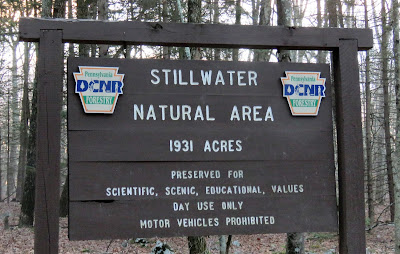
| ... to a left on the Stillwater Natural Area Loop (named Coon Swamp Trail on the map). |
 |
| This trail is blazed yellow although at one time it was blazed red. Old red blazes are sometimes visible. |
 |
| The trail starts out as a woods road and runs parallel to Flat Ridge Road which can sometimes be seen to the left. |
 |
| The trail turns right then descends. |
 |
| The trail turns right again with Little Bushkill Creek straight ahead. |
 |
| Upon checking the route on my app it did not look like the trail ever came very close to Little Bushkill Creek and it looked quite scenic down there to the left so we left the trail and went down for a look. |
 |
| Little Bushkill Creek |
 |
| I spotted an old red blaze so it seems the trail did come down this way to the creek before it was reblazed yellow and apparently rerouted. That's a shame because it is very pretty along the old route. |
 |
| Little Bushkill Creek from the old red trail. |
 |
| Although the old trail was obliterated with blowdowns that we had to maneuver through/around, I saw another red blaze to the right uphill and headed over to that to ... |
 |
| ... meet back up with the yellow trail. |
 |
| Crossing wet area #1 ... |
 |
| ... and immediately after wet area #2. Where these trails are usually muddy since they are along swamps, on this day it was in the 20's so the ground was frozen and there was no mud. |
 |
| Left on the orange-blazed Thunder Swamp Trail which is referred to as the Big Bear Swamp Trail on the signage. It is 1 mile to the loop portion of the trail from this point. |
 |
| Coming up on a bridge over Little Bushkill Creek. |
 |
| The trail turns left ... |
 |
| ... with .3 miles left to the loop. |
 |
| There is a fairly easy water crossing along the way. |
 |
| At the 5-mile loop, I let Brodie decide which way and he chose right, which turned out to be a wise choice. |
 |
| The loop is a wide woods road in either direction but that will be connected with rugged footpath for most of the way. |
 |
| The reason Brodie made a wise choice was that early on we came across this water crossing which normally would not have been an issue but on this day the only way across was on rocks covered in solid ice. Had we gone clockwise around the loop this would have come at the end and had we not been able to cross, it would have been almost 5 miles added to the hike to backtrack. But since I always carry my microspikes in my backpack all winter long no matter where I hike, I was able to use them to cross safely without sliding in. Brodie, however, did not have microspikes and yes, he slid in. |
 |
| The trail becomes a rugged footpath for most of the way. |
 |
| The Thunder Swamp Trail used to be blazed blue and there are still some signs of blue blazes here and there. |
 |
| We had been circling around Big Bear Swamp but had not seen it until we were well into the loop. |
 |
| Part of the trail goes through the swamp on raised roots. |
 |
| Nearing the end of the loop, the trail turns left on the woods road. |
 |
| In the winter you can see the "bowl" of the swamp that we had just circled to the left. |
 |
| At the end of the loop, right to retrace. |
 |
| Staying on the Thunder Swamp Trail passing by where we had come off the yellow trail earlier from the right. |
 |
| Crossing over a dirt road that is part of the Stillwater Natural Area Loop to head towards Painter Swamp staying on the Thunder Swamp Trail. |
 |
| The Thunder Swamp Trail makes a left turn but that would have taken me in the wrong direction. A trail with no visible blazes was straight ahead (according to the map it is blazed yellow) so that was what I wanted heading to Painter Swamp. |
 |
| I eventually lost the trail and ended up at this building (hunting lodge?) a little to the right of where the trail should have been. |
 |
| We turned left on a woods road to the left of the building ... |
 |
| ... and ended up at Painter Swamp where a yellow-blazed trail came in from the left, the trail I was supposed to be on. |
 |
| Painter Swamp |
 |
| We turned right on the Painter Swamp Loop, referred to as Painter Swamp East Trail on the map. |
 |
| Nice winter views of Painter Swamp along the way. |
 |
| The northern end of Painter Swamp. |
 |
| Keeping straight leaving the Painter Swamp Trail where the other side of the loop comes in from the left. |
 |
| This woods road leads back to the parking lot. |
 |
| Passing a trail register box ... |
 |
| ... with no register inside. |
 |
| This was a great hike for solitude - we did not encounter anyone else the entire day. |


No comments:
Post a Comment