ABOUT THE PARK:Appalachian Trail Pennsylvania - The Appalachian Trail Conservancy
DIRECTIONS:GPS Coordinates 40.506803, -76.377130
 |
| Route 645 Parking |
HIKE DISTANCE: 12.3 miles out and back with side trips
THE HIKE:
 |
| Heading north on the Appalachian trail across the street from the parking area. |
 |
| This section of trail was a running stream after 3 days of rain but it could have been worse. A thru-hiker showed me a video of the day before when he hiked up a trail in mid-shin deep running water. |
 |
| There were even little waterfalls in the trail. |
The trail wasn't always wet - it was actually mostly dry - but this is what the wet parts sounded like:
 |
| That is a thru-hiker in the distance; I encountered several throughout the early part of the hike. |
 |
| I noticed a purplish/pink-blazed side trail and decided to see where it went. |
 |
| We followed it downhill until ... |
 |
| ... it started to switchback down the steepest part. I then realized it was most likely an access trail for Camp Swatara so we headed back up. |
 |
| Continuing on the Appalachian Trail. |
 |
| There are a couple of overlooks along the way. This first side trail on the right leads to ... |
 |
| ... a not so nice overlook. But a few steps further along the trail ... |
 |
| ... Fisher Overlook has a nice view. |
 |
| Fisher Overlook |
 |
| Having enjoyed surprisingly smooth trail for the first mile of the hike, that would be intermittent from this point forward. |
 |
| Veery |
 |
| At a clearing, a nice view to the right which is about the same view as ... |
 |
| ... Kimmel Overlook a few steps ahead. |
 |
| Kimmel Overlook is close to a road and parking so there is litter, graffiti, and later in the day lots of people. |
 |
| Coming up on Route 501 crossing. |
 |
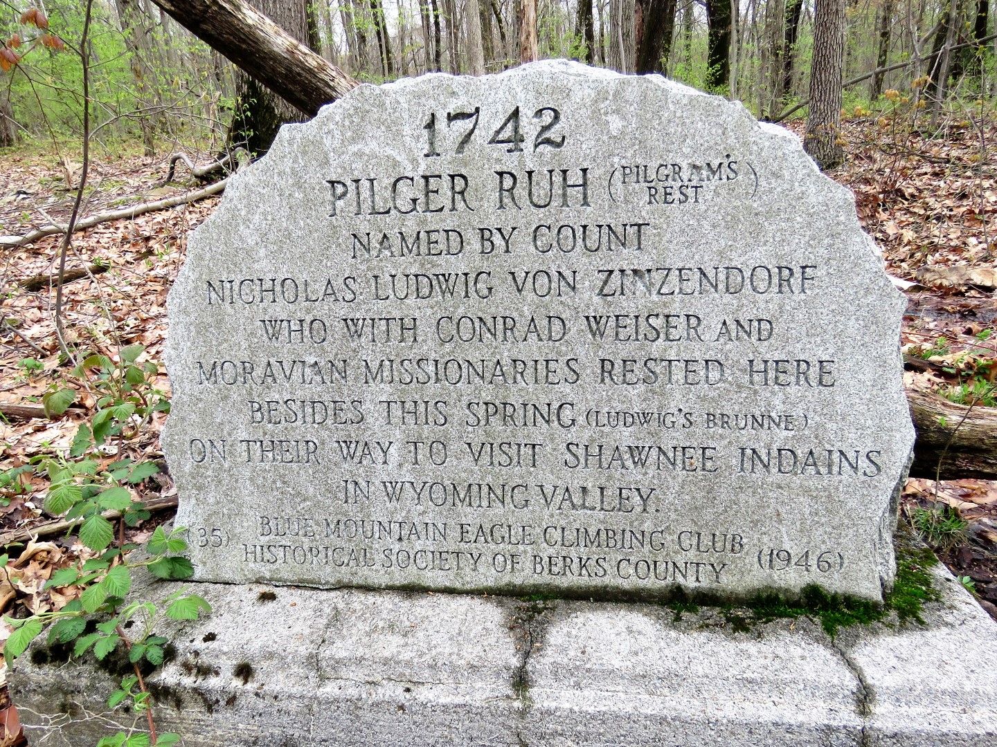
| At this intersection we turned right towards the spring as it has historical significance. |
 |
| I seriously doubt that PVC pipe was there in the 1700's. |
 |
| We took the woods road back instead of the blue-blazed trail. |
 |
| The AT crosses over - we turned right. |
 |
| Black-and-White Warbler |
 |
| A view of Round Head from the trail. There used to be a blue-blazed trail called the Kessel Trail that descended from here and came up the Shower Steps Trail to the overlook on Round Head but that trail was closed a long time ago and there is no evidence of it any more. |
 |
| All I could think of going over these many, many, many sharp and pointy rocks was that I was going to have to do it all over again on the way back. Maybe because that was not on my mind during the return trip, it actually was not that bad. |

 |
| Just when the trail smooths ... |
 |
| ... it makes a turn to the right and there is evidence of a footpath to the left. My old 1998 map shows a trail here so I thought I would give it a try to cut off the big loop around to Round Head so I could meet up with where I left off previously, capturing Round Head on the way back |
 |
| The trail fizzled out and it ended up being a bushwhack but it was doable and I just headed in the direction of the AT where it looped around from Round Head. |
 |
| Ta da! Back on the AT where we turned left. |
 |
| Now heading back and around the loop to Round Head. |
 |
| The view at Round Head. |
 |
| Showers Steps (500 steps) going down to Route 501. I had considered going that way and road walking Route 501 back around to the AT but there is no shoulder, crazy fast traffic, just not safe to do. Plus, having bushwhacked over to the other side, we still had a section of the AT to hike that I would have otherwise missed. |
 |
| One last look ... |
 |
| ... and continuing on. |
 |
| The AT turns left where we had started the bushwhack to the right; now retracing. |
 |
| Ovenbird |
 |
| I went down a few woods roads/trails that cross over the AT and they all ended at private property. |
 |
| Crossing back over Route 501. |
 |
| The parking lot was now very packed and I had been running into many non-hikers. |
 |
| Coming back up on Kessel Overlook where there were now many people hanging out. |
 |
| I managed to snap a shot with blue sky instead of the clouds of the morning while some children were petting Brodie. He would stand there all day for that so I had to drag him along. |
 |
| A little further along at that clearing, we had the view all to ourselves. |
 |
| I-78 five miles in the distance. |
 |
| Back across that last rocky section ... |
 |
| ... then smooth sailing the last mile except ... |
 |
| ... for dodging waterfalls in the trail. |
 |
| Back to the parking lot which was not at all crowded. That would be because it is not close to any overlooks so it's basically only used by hikers and not the majority who are headed directly to the overlooks. |
Not too many wildflower out yet.


No comments:
Post a Comment