

ABOUT THE PARK:
Taconic State Park, NY - NY/NJ Trail Conference Description
Mount Washington State Forest, MA - Massachusetts DCR
TRAIL MAP:
NY/NJ Trail Conference South Taconic Trails Map
Mount Washington State Forest Map - Massachusetts DCR
Most of this hike is in Mount Washington State Forest.

DIRECTIONS:
At first I thought my GPS was malfunctioning since it took me north through Taconic State Park to head back south instead of from south to north through Salisbury, CT, which is the direct route Google Maps gives. I headed south through Salisbury, CT on the way home and now I know why the northern route was better. Heading south towards Salisbury, CT you will be on 7 miles of rutted gravel road hoping another vehicle is not coming towards you because it would be a very tight squeeze. There are even warning signs to proceed at your own risk. It wasn't all that bad since I did not run into other cars, but the northern route would actually be faster and easier so I would recommend going that way. The GPS coordinates that took me on the northern route to the Mt. Frissel trailhead parking lot:

From the New York State Thruway I-87, take the Saw Mill Parkway north to I-684 north. I-684 north turns into 22 north. Stay on 22 north all the way to Copake Falls, NY, (50 some miles) then turn right on 344 through Taconic State Park, right on West Street, right on East Street at the Mount Washington Forest Headquarters entrance, two miles farther to the Mt Frissel trailhead parking on the right. (I believe as East Street crosses the state line into CT it becomes Mt Washington Road.) If full, the AMC lot is 100 feet farther on the left. The drive was just under 3 hours from Central New Jersey.

HIKE DISTANCE: 11 mile loop. It seems that most people parking at the Mt. Frissell trailhead were doing an out and back to Brace Mountain which would be about 5 miles total.
HIKE DIRECTIONS:
With the exception of one short section around Alander Mountain, the trails are very well defined, well blazed and intersections are clearly marked. Made for very enjoyable hiking!
Start at the red-blazed Mr. Frissell trail in the smaller parking lot. On this 2.2 mile trail you will hike in 3 states, cross the summits of Round Mountain and Mt. Frissell (CT high point with actual summit in MA) with great views and pass by the 1898 tri-state marker which indicates where CT, NY and MA come together. There will be some steep rock scrambles while ascending the summits. I found this trail to be the most difficult of the hike so you get that out of the way early on.


The orange-blazed Mount Frissell Trail ends at the white-blazed South Taconic Trail where there are more great views to the south and west.


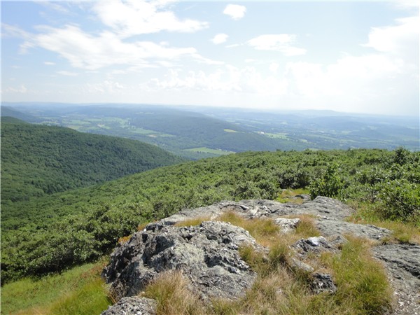
Turn right heading north on the white-blazed South Taconic Trail. For about the next 2 miles the trail will be a pleasant and easy woods road through pretty, quite, shaded forest with minor ups and downs. When you reach the intersection with the Alander Brook Trail, keep right on the South Taconic Trail where it will begin to go uphill steeply on Alander Mountain. There are no rock scrambles but it is a long uphill climb to the fantastic 360 degree views at the top.
Views of Mount Frissell and Brace Mountain to south:

Views of the Catskills to the west:


Old fire tower foundation:

Very shortly after passing the fire tower foundation, watch for the cairn with a very faint blue blaze below it. This is where the trail gets tricky briefly. Turn right at the cairn where the trail will be overgrown, the blazes very faded if you can see them at all, and you will think you are on the wrong trail.

It's not for very long and you will come out at an intersection with a cabin straight ahead. All the trails are blue-blazed here and you do not want the loop trails or they will take you back around to where you came from. Keep straight passing the cabin on your right and you will be on the blue-blazed Alander Mountain Trail which goes to the Mount Washington State Park headquarters.

The Alander Mountain Tail blazes will become blue rectangles that will be angled to point in the direction you need to go.

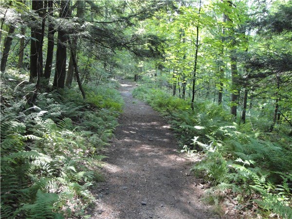
This trail will take you on woods roads through pleasant, thick, dark hemlock forests.
Up to this point, all of the brook crossings were dry due to the lack of rainfall but you will start to hear Ashley Hill Brook as it parallels the Alander Mountain trail in the valley below and a sturdy log bridge takes you to the other side when the trail crosses over.


Farther up the trail there is another smaller brook crossing.

Keep straight through a mowed field...

...which brings you to the Alander Mountain Trail trailhead at the Mount Washington State Forest headquarters. (This view is looking back in the direction I came from.)

Veer right through the parking lot continuing on towards the headquarters building. On the far side of the building is a spigot far drinking water. Great tasting water - my dog and I really appreciated the refill!

Exiting Mount Washington State Forest headquarters, turn right on East Street which is paved until beyond the bridge where it becomes gravel. You will be on this road for a little over two miles until you arrive back at the parking area on the right. The road becomes shaded and it is a very pleasant and easy walk through the Massachusetts countryside.


LITTER REPORT:
This was the only litter I found were these small rip-off pieces that can easily fall out of pockets so I am not even considering them litter. Even along East Street, a gravel road where you would expect to find it, amazingly, no litter.

I love that you take pictures of the litter on all your trips. What a good reminder to people that what is left behind and forgotten by them is a new memory to others.
ReplyDeleteLooks nice
ReplyDeleteGreat Help! Can you tell me more about the cabin?
ReplyDeleteSorry, I don't know anything about the cabin. You would need to contact Mount Washington State Forest.
ReplyDeleteYour photos and trail descriptions are wonderful. Thanks for doing this.
ReplyDeletegreat pics. this is a hike i should do
ReplyDeleteI would like to do this Hike, March 13, is it a bad time? or this is better to do it when it's warmer?
ReplyDeleteI really couldn't say since I have never hiked there other than summer/fall. I would guess it is a matter of personal preference.
DeleteDaniela