ABOUT THE PARK:
DIRECTIONS:
GPS Coordinates 41.730742, -74.298157
 |
| Parking lot at the end of Shaft 2A Road. |
HIKE DISTANCE: 12 miles
THE HIKE:
I had planned this hike a few years ago but had to put it off due to trail closures from the
fire in 2022.
Specifically, I needed to know about the Stony Kill Carriage Road as I needed that to connect to other trails for this hike. There was no longer anything on the website about the closures so I called the park to be sure. I even mentioned the trails by name. I was told everything was open. Keep that in mind for later.
 |
| Trail closures from the fire in 2022 - still closed in 2023. |
 |
| The trail goes through an old quarry... |
 |
| ... before entering the woods. |
 |
| The falls are visible through the trees very early on. |
 |
| From the first bridge. |
 |
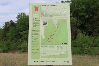
| The stone steps begin and there are lots and lots of them. |
 |
| Stony Kill Falls from the viewing platform. |
 |
| More stone steps. |
 |
| Then we get to the ladder rungs that I had concerns about with Brodie but they were at an angle, not straight up, and it was very short. My main fear was Brodie stepping on a rung, his leg going through and getting injured so the challenge was to keep him to the side away from the rungs which, with the handle on his backpack, was much easier than I expected. |
 |
| Looking back down the ladder rungs. |
 |
| Some views at the top of the falls. |
 |
| Some more falls at the top. |
 |
| At the very end we turned back a short distance ... |
 |
| ... and continued to the right on the Stony Kill Carriage Road. |
 |
| It becomes narrower fairly early on ... |
 |
| ... to becoming a footpath the rest of the way. |
 |
| It is often very rocky and eroded with a few downed trees that are easy to get over. |
 |
| After a week of rain, it was also very wet. |
 |
| So many birds singing up at the top. |
 |
| Coming out at the Smiley Carriage Road - wait what is that up ahead? |
 |
| Are you kidding me? This is the trail I had asked about and was told it was open. Well, I will have to be going back that way to get to my car later on. |
 |
| For now, a right on the Smiley Carriage Road. |
 |
| Mohonk Mountain House in the distance. |
 |
| The Berrypicker Trail, which is also the route of the Long Path, comes in from the left. We would be looping around and coming out that way later. |
 |
| Finally saw one of the singers. |
 |
| Coming up on Napanoch Point. |
 |
| When I hiked here in 2021 this was where the manicured carriage road ended and it was all natural from here forward. I liked that a lot better. |
 |
| Left on the red High Point Trail. |
 |
| Starting the Berrypicker Trail/Long Path. |
 |
| The vegetation is really encroaching on the trail at this end. |
 |
| Coming out at the Smiley Carriage Road, turning right to retrace. |
 |
| We were mostly in full sun exposure and it was hot so Brodie gladly cooled off in some water. |
 |
| Future tadpoles. |
 |
| Back to retracing on the Stony Kill Carriage Road that was not supposed to be closed. |
 |
| I expected sirens to go off but nothing happened. I saw a lot more footprints in the mud than when I was on the trail earlier so others are using it, too. |
 |
| Coming back out at the falls ... |
 |
| ... and down the many, many steps which is really hard on the knees going on 12 miles. |
 |
| One last look at the falls on the way down. |


breathtaking view at Napanoch Point. I love the Catskills but 2+ hours in the car each way is bit much for me for 1 day.
ReplyDeleteWith your hike at just above 8 hours, what time did you leave in the morning and what time did you return home?
I left at 6AM and pulled into the parking lot at 8:15 AM. I had detoured for gas in Parsippany on the way so added a bit of time. (There is a Conoco station that has better gas prices than around here so it's worth a bit of a detour on the way to hikes to fill up.) I texted my son that I was back home at 7:34 PM so it would be been a bit before 7:30 PM when I arrived. I avoid taking the NY Thruway home on a Sunday night and I absolutely will not drive through New Paltz going home and avoid the GSP at all cost. That can add an hour inching along in traffic. So I take back roads heading towards West Milford then on to I-287 and that adds a little bit of time but it's a prettier drive with much less traffic.
DeleteWhat bird ID App do you use? I use Bird Net but yours looks more colorful. Funny, just saw a common yellowthroat myself this weekend. Not "common". Thanks --Ken K. in NJ
ReplyDeleteIt's the Merlin Bird ID app. I believe I had to download the sound ID package separately but once you have it, it is part of the app. It's so much fun to use because you can tell which birds you hear that you cannot see.
DeleteWhen it IDs a bird, every time that type of bird sings the line turns yellow so
you know which bird it is when there are multiple birds.
https://merlin.allaboutbirds.org/sound-id/
Thanks for the info. I'm pretty sure you're right about the ID being an add-on. I tried that app several years ago and don't think it had the ID add-on at the time. Probably why I switched to Bird Net, but I don't recall exactly.
Delete