ABOUT THE PARK:
Slide Mountain Wilderness - New York DEC
DIRECTIONS:
GPS Coordinates 42.10031, -74.39021
 |
| Fox Hollow Parking |
TRAIL MAP:
Northeastern Catskill Trails Map 142 - New York New Jersey Trail Conference
HIKE DISTANCE: 10.25 miles (5.1 miles each way)
THE HIKE:
Even though I had just been to the Catskills the weekend before, foliage was not where I had expected it would be so what to do but go back again. Foliage was much farther along just one week later.
 |
| The blue Giant Ledge-Panther-Fox Hollow Trail starts at the far right corner of the parking lot. |
 |
| The trail register a short distance in. |
 |
| Brodie is not into getting his paws wet so he managed to take the log over the small creek. |
 |
| The trail climbs pretty consistently on an old woods road for the first 1.5 miles, at times steeper and less steep but with very few flat stretches. The total elevation gain for this hike is 2,782 feet, most of it within the first 3 miles. |
 |
| I had read from a few years back where the trail was hard to follow with blow downs and overgrowth but I did not find that to be the case at all now. |
 |
| Just half of a mile in, a side trail to a spring and shelter. |
 |
| Finally, after 1.5 miles of uphill, a long flat stretch. |
 |
| And time for a break. |
 |
| Once you hit 3000 feet (apparently there used to be a sign but it's no longer there) the terrain becomes much rockier. |
 |
| Yes, another break. We took lots of breaks. |
 |
| Rock scrambles, which Brodie was quite good at. |
 |
| He is starting to look like he belongs here. |
 |
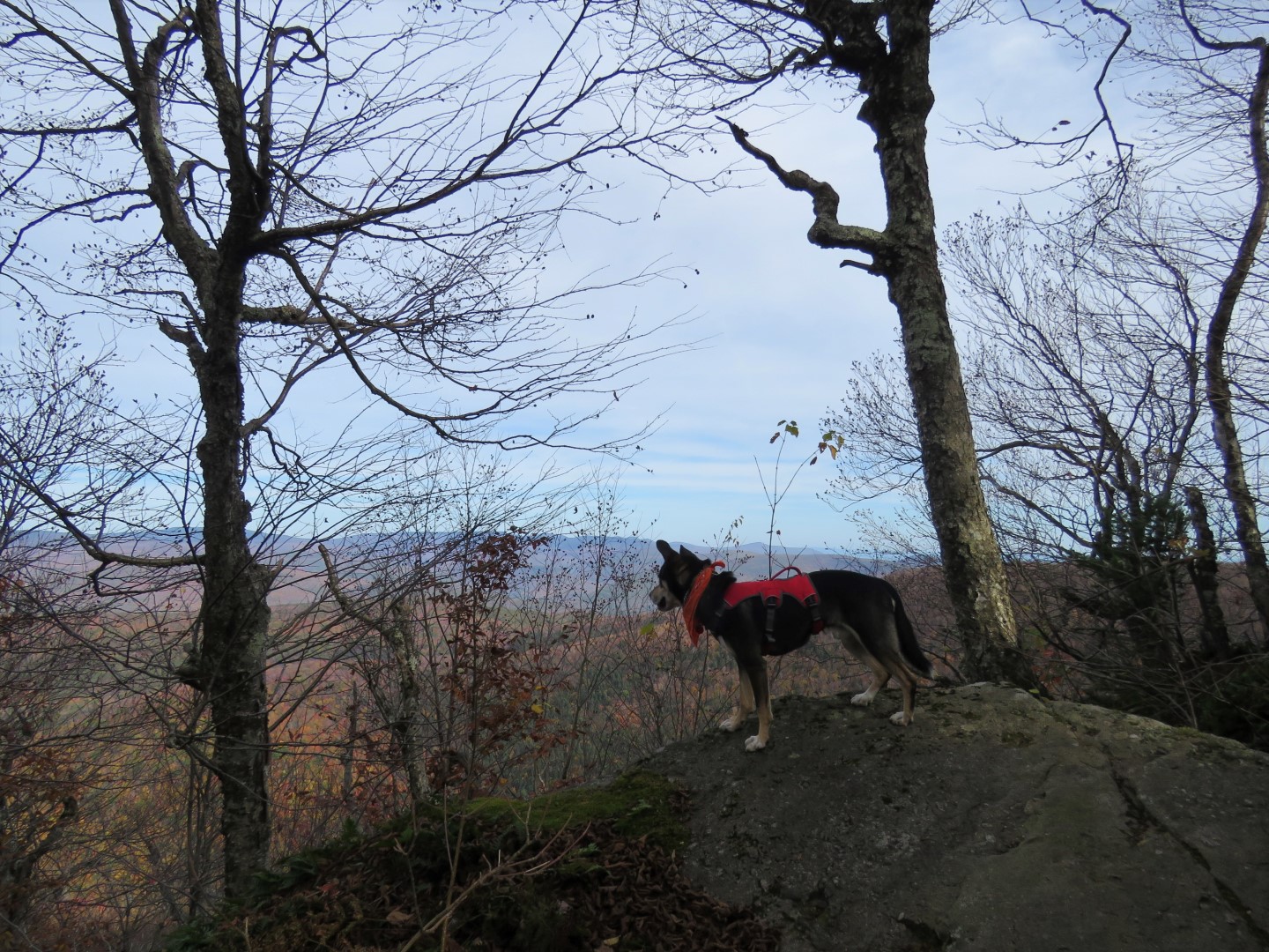
| Mountain Views! |
 |
| There are two false summits that require scrambling up and over and back down. |
 |
| Now scrambling up to Panther Mountain views and the summit. I actually had to let Brodie off leash for these since it was becoming too dangerous for both of us to be tethered together. Dogs are allowed off leash in the Catskills as long as they are under voice control and leashed when others are around. Fortunately, Brodie found his own way and waited for me to catch up but still to early in his training to totally trust him so after the scrambles, the leash went back on. |
 |
| To the left a window to ... |
 |
| ... another view. |
 |
| There were other hikers at the next view on a nice flat rock slab so I decided to wait until our return route to see if it would be free then. |
 |
| The summit sign is also missing and I overshot it by just a bit so we started back. |
 |
| Some others had passed us and were at the summit overlook. Brodie immediately started schmoozing. I tried to stop him but they all said it was fine. |
 |
| Here we are at the summit with Brodie still schmoozing. |
 |
| Heading back. Other than those two upcoming false summits, it's pretty much downhill all the way. |
 |
| The view that was previously occupied, now vacant. |
 |
| So that is where we took a long break. |
 |
| This butterfly hovered right in front of me then landed on my arm but I could not get my camera into my other hand fast enough to get a picture of him before he realized the error of his ways. |
 |
| There he is in a proper place. |
 |
| Brodie was becoming braver off leash on the downhill scrambles, probably because he could follow our scent. Here he is on the ledge at one of the overlooks we had stopped at where he waited for me to catch up. |
 |
| We had been practicing recalls with the flexi lead (in particular each time he would fixate on a chipmunk) and when I would call him while off leash he would bound back to me quickly. |
 |
| But he was getting a little too brave and getting out of sight so that was the end of off leash for the day. |
 |
| It was 4:30 PM when I ran into these people heading up, all with cameras. They were clearly not hikers and not at all dressed for hiking so I asked them if they were wanting to get pictures at overlooks. They said yes and asked how far to Slide Mountain. I told them at least 3 miles to an overlook and many, many more miles to Slide Mountain and there was no way they would make it before dark. They thanked me and headed back down. I think I saved search and rescue at trip out in the dark! |
 |
| Back at the water crossing at the trail register - Brodie got the puncheon this time. |
 |
| This was a very lightly traveled trail. Those who came after me seemed to be continuing on to Giant Ledge doing shuttles back. No doubt this trail coming in the other direction up to Giant Ledge is swamped with hikers. I had hiked that several years ago with Shawnee and it was very busy then. |
 |
| Back at the parking lot. |
 |
| One very tired dog on the 2.5 hour ride home. |


You got some beautiful shots of foliage and mountain views. So glad Brodie is such a great companion to you on these hikes! Thanks for sharing. Joanne from NJ
ReplyDeleteThanks, Joanne. Brodie does better on every hike. I'll always miss Shawnee but love having Brodie along. Hiking just isn't the same without a dog.
DeleteDaniela
Hello !
ReplyDeleteQuick question: which are the most bike-able (with a mountain bike) trails in Harriman State Park ? I'm looking primarily for carriage roads, dirt roads or single trails (avoiding asphalt as much as possible).
Thanks !
I have never seen mountain bikes in Harriman and I don't believe they are allowed other than maybe certain trails out of Anthony Wayne Recreation Area. You might want to check jorba.org for better places to ride in NJ. In NY across the Hudson from Harriman is Blue Mountain Reservation that allows mountain biking http://parks.westchestergov.com/blue-mountain-reservation
DeleteDaniela
Wonderful photos. Thank you for sharing. I got a really great sense of the terrain from your shots.
ReplyDeleteThanks!
DeleteI miss reading about Shawnee, I am glad you have a new companion.
ReplyDeleteI love that way up to Panther.
Thanks. I miss hiking with her It was a year August 1. Can't believe she has been gone that long. Brodie is a good hiking companion, too, but in a different way. There will only be one Shawnee.
Delete