Sunday, March 14, 2021

Amico Island Park, NJ

ABOUT THE PARK: 
Amico Island Park - Burlington County 

DIRECTIONS: 
GPS Coordinates 40.037702, -74.978359
Huge parking lot.  My GPS was telling me to turn right when the entrance to the parking lot was on the left so watch for the park sign in case your GPS goes rogue.

TRAIL MAP: 
Amico Island Park - Burlington County Parks

HIKE DISTANCE: 
This was the most I have hiked in one day post-surgery.  Breaking it up into smaller hikes with 15-20 minute drives in between made my first day of 7.5 miles easy to do.

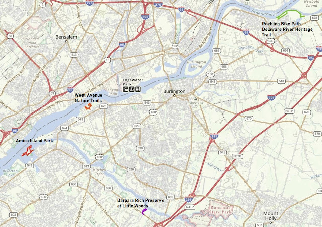
Roebling Bike Path/ Delaware River Heritage Trail - 3.3 miles
    10 miles/20 minutes to
West Avenue Nature Trails - 1.4 miles
    4 miles/11 minutes to
Amico Island Park - 1.9 miles
    6 miles/13 minutes to
Little Woods on the Rancocas - .85 miles 

THE HIKE: 
At first I was a little put off by the amount of cars in the parking lot, expecting the trails to be crowded.  Surprisingly that was not the case.  I actually ran into very few other people out on the trails.
Straight through the parking lot to the start of the trails.
We turned right to loop around counterclockwise, starting between the pond on the left ...
... and Rancocas Creek on the right.
A great blue heron in Rancocas Creek.
At the confluence of the Delaware River and Rancocas Creek.
There are some footpaths not on the  map that run alongside the wider official trails.
Along the bank of the Delaware River.
We took a side path to ...
... views of Philadelphia.
But there was an official overlook a little farther along.
Philly again.
Now following along the other side of that pond from where we were at the beginning.
Seagulls in the Delaware River on a VERY windy day, hence the whitecaps.
Carolina Wren
South Overlook with a great blue heron rookery on the island.  I forgot to zoom in for a better look at the rookery because ...
... I was intent on following this path to the point of the island and forgot about the rookery.
At the point of the island with Philadelphia in the distance.
Heading back on the path.
Coming back up on the parking lot.

Roebling Bike Path/Delaware River Heritage Trail , NJ


ABOUT THE PARK: 
Roebling Bike Path - nothing online.  I am not even sure that is what it is called but "bike path" signs all through town lead to it. 
 
DIRECTIONS: 
 GPS Coordinates 40.11825, -74.78174
Very limited parking at the end of 10th Avenue but ...
... lots of parking one block away all down the middle of Main Street to the right ...
... and to the left.

TRAIL MAP: 
The Roebling bike trail is to the east of the Delaware River Heritage Trail (or it may all be one and the same).


HIKE DISTANCE: 
This was the most I hiked in one day post-surgery.  Breaking it up into smaller hikes with 10-20 minute drives in between made my first day of 7.5 miles easy to accomplish.
 
Roebling Bike Path/ Delaware River Heritage Trail - 3.3 miles
    10 miles/20 minutes to
West Avenue Nature Trails - 1.4 miles
    4 miles/11 minutes to
Amico Island Park - 1.9 miles
    6 miles/13 minutes to
Little Woods on the Rancocas - .85 miles
  
THE HIKE:
The paved path begins at the end of 10th Avenue.
At the intersection we turned left and would be returning from the right.
This would be where those goats would be but they are apparently still on winter break as none were to be seen.
The path curves to the right following along the Delaware River.
Yay for lots of trash cans.  Once we start doing longer hikes and Brodie can carry it in his backpack and trash cans won't matter.
A bufflehead couple.
At first I thought this was a hawk but when I zoom in the head and beak look like that of an eagle so it might be a juvenile bald eagle.
To the right returns to where we started, straight ahead dead ends at a fence, left is where the Delaware River Heritage Trail section begins according to the map.
Some mallards and common mergansers.
Ducks dining.
The path passes along the abandoned Roebling steel mill site on the right.
Lots of female buffleheads.
If the boy buffleheads are looking for the girl buffleheads, they are straight ahead.
Ugh, a balloon I can't reach on the other side of the fence.
The path follows along live railroad tracks.
Apparently a railroad crossing dispute did not allow for the trail to go through but a resolution has been reached and ...
... according to this article, once this 1.3 million dollar crossing is complete the fence will go down and crossing will be allowed to continue on the trail.
But today this had to be our turn around point since crossing is still prohibited.
Coming back up on that intersection at the Roebling bike trails, we turned left.
Looks like a dog park on the left.  Nobody was there ...
... so in we went.
How nice, a dog park with a view of the Delaware River, although Brodie could have cared less about the views.
To the left leads to  Riverside Avenue - there are two such forks.
A left at the third fork leads back to 10th Avenue where we parked.
Note that there is no parking across the white line in the circle part of the road.