Wednesday, August 24, 2011

Taconic State Park, NY and Mt. Washington State Forest, MA: Alander Mountain to Brace Mountain


ABOUT THE PARKS:
Taconic State Park, NY - New York State Office of Parks and Recreation
Mt. Washington State Forest, MA - Massachusetts DCR
Alander Mountain - Wikipedia
Brace Mountain - Wikipedia
Paragliding and Hang Gliding on Brace Mountain - Mount Brace Outdoor Club

DIRECTIONS:
This is a two car shuttle hike - see notes at bottom***

Leave car #1 at end of hike:
GPS Coordinates for Alander Brook Trail Parking: 42.065784, -73.515586

View Larger Map
Note that the trailhead is not at this parking lot - it is a short distance west around the bend of Undermountain Road on the right.  Although there is space, there are no parking signs at the trailhead.
Signs at the trailhead.

Drive car #2 to the beginning of the hike:
GPS Coordinates for Taconic State Park parking lot: 42.117150, -73.507789

View Larger Map
Pick up the South Taconic Trail to the right of the porta-potties in the parking lot.

TRAIL MAPS:
Mt. Washington State Forest Trail Map - Massachusetts DCR (does not show entire hike)
South Taconic Trails - NY/NJ Trail Conference (does not show car #1 parking)
South Taconic Range Map - Berkshire Natural Resources Council, Inc.

HIKE DISTANCE:  11.2 miles

PEAK BAGGING:
Alander Mountain
Brace Mountain

THE HIKE:
Starting along the path leaving the parking lot to the left of the porta-potties, you will soon see the white blazes of the South Taconic Trail.  Follow to the left towards Bash Bish Brook.  At the T-intersection just before Bash Bish Brook, turn left on the gravel road and proceed over a bridge towards cabins.
The gravel road bridge as seen from the parking lot.
Just before the cabins, the South Taconic Trail enters the woods to the right on a footpath.
The trail ascends steeply but with no rock scrambles.  In just a little over a mile, a short blue-blazed side trail to the left leads to a view:
Click twice to enlarge.
In another .15 mile, arrive at an intersection with a blue-blazed trail, noted as "SIDE TRAIL" on the sign below.  This trail leads to Bash Bish Falls.  We had intended to park car #2 in the Bash Bish Falls parking lot and begin the hike there but were unable to locate the trailhead for this blue-blazed trail.  A hiker we ran into later told us it starts beyond the metal gate to the left of the parking lot - the only place we hadn't looked.
Be sure to turn around at the 3.1 mile point for a view to the north.  On a clear day you should be able to see Mount Greylock, the highest mountain in Massachusetts.
Mt. Greylock in the far center.
In another 10th of a mile, views to the west:

A little farther along arrive at the top of Alander Mountain with great views.
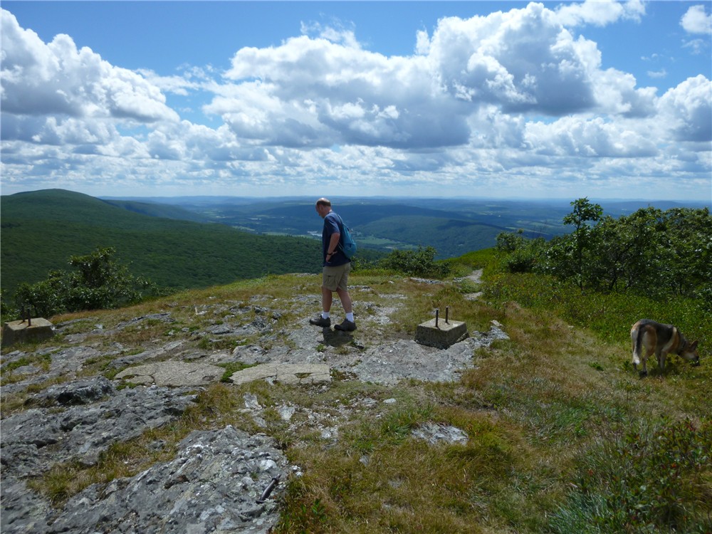
Old fire tower footings at the top of Alander Mountain; Brace Mountain to the left.
Click twice to enlarge.
At 5.1 miles, make note of the red-blazed Robert Brook Trail which goes to the right.  From this point it will be an out-and-back to Brace Mountain as the Robert Brook Trail leads to where car #1 is parked. 

At 6.3 miles the trail splits.  The forks merge back together a short distance ahead but the right fork will bring you to a view.  Be careful when the forks merge back together because a blue-blazed trail also comes in at this point and the blazes are not very obvious. Be sure to stay on the white-blazed trail, coming from the view you would turn right.
You might see paragliders just before reaching Brace Mountain.

 You will catch a glimpse of Mount Brace soon and it looks like a steep climb but amazingly, it is not.  It is actually a very easy .4 mile to the summit and you are there before you know it.
Brace Mountain summit from less than 1/2 mile away.
Brace Mountain Summit
Views from Brace Mountain:
The Hudson Valley and Catskills
Head back the way you came on the South Taconic Trail turning left on the red-blazed Robert Brook Trail.
Pass two different NY/MA state boundary markers.
The Robert Brook Trail descends through pretty forests with a ravine to the left.

HIKE SUMMARY: 
[  0.00]  Pick up white-blazed South Taconic Trail to the right of the porta-potties
[  1.10]  Left on blue side trail to view; retrace
[  1.20]  Continue left on white South Taconic Trail after returning from view
[  1.35]  Stay on white trail when blue-blazed trail goes left
[  3.10]  Turn around for view to the north
[  3.20]  View to the west
[  3.40]  Continue on white-blazed South Taconic Trail at intersection where trails to left go to park headquarters at the top of Alander Mountain
[  4.65]  Keep straight on South Taconic Trail when blue-blazed Alander Loop Trail comes in from the left
[  5.10]  Keep straight on South Taconic Trail when red-blazed Robert Brook Trail goes right
[  6.30]  When trail splits, take the right fork to a view; come out at an intersection with a blue-blazed; keep right on the white-blazed South Taconic Trail
[  7.40]  Summit of Brace Mountain; retrace heading north on South Taconic Trail
[  8.40]  Keep straight when blue-blazed trail goes right
[  9.70]  Turn left on the red-blazed Robert Brook Trail
[  9.90]  Two state line markers
[ 11.05]  At T-intersection Robert Brook Trail ends, turn left on blue-blazed Alander Brook Trail
[ 11.10]  Turn left on paved Undermountain Road and follow around sharp curve
[ 11.20]  Parking area on left

***We had intended to park car #1 at the southern trailhead of the South Taconic Trail here:

View Larger Map
Although I am confident we had the correct spot (across from a house, near the quarry, gravel pullout for parking) we could not find the trail going into the woods, only private property signs and a sign that the land is for sale.  It seems as though the southern trailhead no longer exists so we left the car at the Alander Brook Trail parking area and hiked out and back to Brace Mountain instead of straight through. 

Saturday, August 20, 2011

Worthington State Forest, NJ: Appalachian Trail - Sunfish Pond - Dunnfield Creek Loop


ABOUT THE PARK:
Worthington State Forest - New Jersey Department of Environmental Protection


Click for Columbia, New Jersey Forecast


DIRECTIONS:
GPS Coordinates to Dunnfield Parking: 40.971797, -75.125589

View Larger Map

TRAIL MAP:
Southern Kittatinny Trails Map #120 - NY/NJ Trail Conference

HIKE DISTANCE:  9.1 miles

APPALACHIAN TRAIL SECTION HIKING:
TrailHeadFinder.com - AT section miles 1,279.3 to 1,283.8

THE HIKE:
Pick up the white-blazed Appalachian Trail which goes through the parking lot and to the left of the porta-potty.
The hike starts along scenic Dunnfield Creek.
Dunnfield Creek
Veer left on the A.T. - the Dunnfield Creek Trail on the right will be the return route.
A very foggy morning on the Appalachian Trail.
Beyond the backpacker camping area, fire damage from the forest fire of August 7, 2010 on the left side of the AT, the right side of the AT untouched by the fire.
Sunfish Pond was full of huge tadpoles becoming frogs.
Continue following the Appalachian Trail to the left of the pond skirting along the water on boulders.  At the far end, continue a short distance then turn left on the orange-blazed Springs Trail.  A short distance ahead, enter the far end of a clearing on the left and look for an unmaintained trail which leads up a hill to a view into Pennsylvania.  There are several trails back in there, just pick whichever is easiest to follow up to the top of the hill.
It was still cloudy and hazy so can't say how nice the view would be otherwise.
Return to the A.T., turn right and start watching for the turquoise trail on the left.  The blazes are high up, faded and there are multiple unmarked trails so you need to look carefully.
Turn left on the turquoise-blazed trail.
A short distance ahead, a view of Sunfish Pond from the opposite side.
When the turquoise trail turns left on the Sunfish Pond Fire Road, turn right and follow the unmarked fire road to the green-blazed Dunnfield Creek Trail on the left.
The green-blazed Dunnfield Creek Trail starts out rocky and descends to Dunnfield Creek.
Arriving at Dunnfield Creek.

For the last 3 miles of the hike, this is pretty much what you will be seeing and hearing.  Nice! 


You won't have to worry about this bag of garbage detracting from your view of the waterfalls in Dunnfield Creek.  I packed it out, brought it home, pulled out 12 plastic bottles for recycling and put the rest (Subway wrappers) in my trash can.  So hard to believe 12 people had lunch here and not one of them could carry out their trash.

HIKE SUMMARY:
[  0.00]  Pick up white-blazed Appalachian Trail to the left of the porta-potty in the parking lot
[  0.10]  Cross bridge over Dunnfield Creek
[  0.40]  Keep left on the AT at the fork; the right fork will be the return route
[  1.40]  Keep straight on the AT when the red-blazed Holly Springs Trail goes right and the yellow-blazed Beulahland Trail goes left
[  2.90]  Keep right on AT when the blue-blazed Douglas Trail goes left at the backpacker campsite
[  3.50]  Turn left at the Sunfish Pond sign; pond view to right, keep left on AT along pond
[  4.20]  Turn left on orange-blazed Springs Trail
[  4.30]  Turn left into far end of open area, take unmaintained trail up hill to view; retrace
[  4.50]  From clearing, right on orange-blazed trail
[  4.60]  Turn right on the white-blazed Appalachian Trail
[  4.75]  Turn left on the turquoise-blazed trail
[  4.80]  View of pond on right
[  5.00]  At fire road when turqoise turns left, turn right on unmarked fire road
[  5.50]  Turn left on green-blazed Dunnfield Creek Trail
[  6.35]  Trail starts to parallel Dunnfield Creek
[  7.50]  Keep left on green-blazed Dunnfield Creek Trail when red-blazed Holly Springs Trail goes right
[  8.60]  Keep straight on green-blazed trail when blue-blazed trail comes in from the left
[  8.80]  Left on white-blazed Appalachian Trail
[  9.10]  Back at parking lot

Friday, August 12, 2011

Appalachian Trail from Hoyt Rd., NY to Kent, CT with Herrick Preserve and Bulls Bridge Side Trips


ABOUT THE PARK:
History of the Appalachian Trail in Connecticut - CT AMC
Appalachian Trail Region NJ/NY - NY/NJ Trail Conference
Herrick Preserve - Naromi Land Trust
Bulls Bridge Recreation Area - Litchfield Hills Connecticut Visitor's Bureau

Click for Kent, Connecticut Forecast

DIRECTIONS:
One Car Shuttle Hike
Park Car Here:
GPS Coordinates 41.731029, -73.490691

View Larger Map
CT 341 Roadside Parking at AT Crossing
Contact Backcountry Outfitters in advance to arrange for a shuttle to Hoyt Road from CT 341. (They will shuttle your dog, too!) Park car at CT 341 and walk .6 mile east on CT 341 to Backcountry Outfitters (on the right just before intersection with Route 7) for shuttle.   When I did the hike, the cost of the shuttle was $25 - less costly than gas and tolls to break up this section of the AT into two out-and-back trips.
OR for a two-car shuttle - 
Park Car 2 here:
GPS Coordinates 41.640959, -73.520118
View Larger Map
Hoyt Road Parking at NY/CT State Line

TRAIL MAP:
Connecticut Appalachian Trail Guide (available in map boxes through hike but not very useful)
Appalachian Trail Kent to Rt. 55 - Connecticut Explorer's Guide (very useful topo map)
Herrick Preserve - Naomi Land Trust (detail of first part of AT and side trail to views in Herrick Preserve)
Bulls Bridge Scenic Area Map

HIKE DISTANCE:
AT with all side trips:  15.5 miles
AT only with no side trips: 11.5 miles
Herrick Preserve:  2.35  miles
Bulls Bridge Scenic Area: 1 mile
From Ct 341 parking to Backcountry Outfitters: .6 mile

PEAK BAGGING:
Tenmile Hill, CT
Schaghticoke Mountain, NY
Mount Algo, CT

APPALACHIAN TRAIL SECTION HIKING:
TrailHeadFinder.com - AT section miles 1,434 to 1,445.4

THE HIKE:
For written description, see my NY/NJ Trail Conference writeup.
Starting out on the AT from Hoyt Road
Beginning of the Herrick Trail off of the AT
Blue side trail blazes become Herrick Preserve markers
Housatonic Overlook off of Herrick Trail side trail
Amy's Lookout off of Herrick Trail side trail - a wonderful breezy and mossy break spot
Tenmile River
Ned Anderson Memorial Bridge Over Tenmile River
Housatonic Whitewater
View from Overlook Deck at Bulls Bridge Scenic Area
Bulls Bridge
Canal Headgates at Bulls Bridge Scenic Area
Bulls Bridge Dam
The AT follows along Schaghticoke Road for a short distance.
View of Tenmile Hill from Schaghticoke Mountain
View West from Schaghticoke Mountain
Hiking back into Connecticut from Schaghticoke Mountain summit in New York.
New England Countryside View

HIKE SUMMARY:
[  0.00]  Walk east along CT 341
[  0.60]  Arrive at Backcountry Outfitters; shuttle to Hoyt Road, hike north on white-blazed AT
[  1.00]  Side trail on left to Route 55 parking lot at information board
[  1.05]  Connecticut Appalachian Trail sign
[  1.25]  Cross Route 55 (caution - very fast traffic)
[  1.80]  Trail forks left - easy to miss
[  2.50]  Partial view from short side trail to left
[  2.70]  Right on blue Herrick Trail; blue blazes change to preserve markers
[  3.05]  Turn left on side trail at Housatonic Overlook sign
[  3.15]  View straight ahead at rock outcrop; retrace
[  3.20]  Continue left on Herrick Trail
[  3.80]  Turn left on side trail at Amy's Lookout sign
[  3.95]  Amy's Lookout; retrace
[  4.05]  At intersection turn right on Herrick Trail
[  4.70]  Left at fork when Housatonic Overlook side trail goes right
[  5.05]  Right on white-blazed Appalachian Trail when Herrick Trail ends
[  5.35]  Trail turns sharply to the right where branches cover trail straight ahead
[  5.75]  Cross woods road
[  5.85]  Trail turns right at Tenmile River
[  6.10]  Cross Tenmile River on the Ned Anderson Memorial Bridge (steps may be difficult for dogs)
[  6.20]  Trail crosses power cut
[  6.70]  Bear right at fork on wide gravel road
[  6.85]  AT leaves gravel road to the left into woods; stay on gravel road for scenic side trail along the Housatonic to Bulls Bridge
[  7.10]  Right on paved road, either of two side trail to right goes short distance to overlook deck; retrace and continue right on paved road to Bulls Bridge
[  7.25]  Bulls Bridge straight ahead, turn left on trail between parking lot and bridge to trails along the river to the dam; retrace
[  7.55]  Back at paved road turn right and walk along paved road
[  7.65]  Turn right through field beyond gate to left on trail along Spooner Dam to cut off part of road walking; comes back out on road short distance ahead
[  7.75]  Continue right on paved road
[  7.85]  Turn right on Schaghticoke Road at Indian farm stand sign; now back on AT
[  8.10]  AT leaves road to the left into woods
[  8.90]  Partial views through trees to the left
[  9.70]  View to the south at rock outcrop
[11.00]  NY/CT state line
[11.45]  View to the east at Indian Rocks in the Schaghitoke Indian Reservation
[12.00]  Short side trail to right to view
[12.15]  Stay on white-blazed AT when blue-blazed side trail goes left to Schaghticoke Camping Area
[13.50]  High point; begin descent
[14.10]  Cross Thayer Brook
[14.50]  High point of trail on Mount Algo; begin descent
[15.14]  Stay on white-blazed AT when blue-blazed side trail goes left to Mt. Algo shelter
[15.40]  Cross woods road
[15.50]  AT parking area on CT 341