Sunday, July 24, 2011

Mount Greylock State Reservation, MA: Greylock in the Round


ABOUT THE PARK:
Mount Greylock State Reservation - Massachusetts Department of Conservation and Recreation
Click for North Adams, Massachusetts 
Forecast

DIRECTIONS:
GPS Coordinates to Rockwell Road/Sperry Road Parking 42.624380, -73.190564

View Larger Map

There is room for about 10 cars in this lot.  Sperry Road starts directly across from this parking area.  Although Sperry Road is off limits to cars (some older maps still show it as being accessible for cars) you can drive in a short distance where there are additional pull-outs on the right side for parking.

NOTE:  This hike, Hike #4 - Greylock in the Round, starts in a different lot off of Hopper Road.  I picked the Sperry Road lot since I had others with me that would be hiking a shorter route with less elevation gain so this parking area was a better starting point for them.  This turned out to be a good choice as the sun was setting at the end of the hike and the trails were becoming very dark.  Hiking down to Hopper Road that late in the day to get back to the car would have involved a steep descent going down into an even darker valley.  Having parked on Sperry Road, we had the option of abandoning the darker trail and taking the paved Rockwell Road back to the car for some gorgeous sunset views along the way.

TRAIL MAP:
Mount Greylock State Reservation Summer Use Trail Map - MA DCR  (most up to date map)
Mount Greylock Trail Guide & Map - Berkshire Natural Resources Council, Inc.  (very nice map but a little outdated)

HIKE DISTANCE:  12.4 miles

HIKE DESCRIPTION:
All trails are blazed in blue except the Appalachian Trail which has white blazes.  The Haley Farm Trail will have a few white blazes interspersed with the blue.  Intersections are very well marked with trail names.  While there are no rock scrambles along this route, there are several long, steep inclines and switchbacks.
Beginning of Sperry Road across Rockwell Road from Parking Area
Mr. Greylock Summit War Memorial as seen from Stony Ledge
Haley Farm Trail
View From Haley Farm Trail
Field crossing at Bottom of Haley Farm Trail
Money Brook Trail
Hiking Through The Hopper
Money Brook Falls (low water flow end of July)
Meeting Up with the Appalachian Trail
Williamstown with Adirondacks in the distance from Mount Prospect View
Mount Williams Summit
View From Mount Williams
Crossing the road on the way to Mount Greylock summit
Approaching the War Memorial on the summit
Bascom Lodge at the summit.
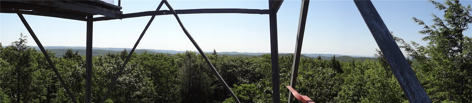
Summit View
Small Pond off of Appalachian Trail
Sunset along paved Rockwell Road heading back to parking area.


HIKE SUMMARY:
[  0.00]  Cross Rockwell Road and follow Sperry Road (gravel road) beyond barrier
[  1.50]  Stoney Ledge Overlook; at far end of Sperry Road, follow trail into woods towards Stoney Ledge Campsite veering left at fork just before campsite
[  1.65]  Turn right on Haley Farm Trail when Stoney Ledge Trail goes left
[  1.95]  Short side trail on right to view
[  2.50]  White blazes interspersed with blue blazes on Haley Farm Trail - still correct trail
[  3.50]  Keep to the left of the field towards sign then continue straight to woods and right on the dirt road
[  3.60]  Keep straight on dirt road when Hopper Brook Loop Trail (not on map) goes left
[  3.65]  Keep straight on dirt road which is now Money Brook Trail when Hopper Trail goes right
[  3.75]  Keep straight on Money Brook Trail which now becomes grass road when the other side of the Hopper Brook Loop trail comes in from the left
[  3.85]  The Hopper sign
[  3.95]  Cross bridge with Bob Quay memorial sign
[  4.05]  Cross small bridge over gully and turn left on trail going uphill away from Money Brook (this is a bypass that joins up with the trail along the brook again)
[  4.15]  Left on trail meeting back up with brook again
[  4.50]  Cross footbridge to right over brook; trail continues left other side of bridge; cutoff to Hopper Trail goes right
[  4.60]  Rock hop to left over side creek
[  4.90]  Rock hop over creek (was almost dry creek bed during this hike); trail continues to the left after crossing
[  4.95]  Keep right on Money Brook Trail when Mount Prospect Trail goes left
[  5.95]  Keep straight following arrow to Money Brook Falls, left goes to Appalachian Trail (will return to take this trail after short out and back to falls)
[  6.00]  Money Brook Falls; retrace to AT intersection
[  6.05]  At intersection turn right towards Wilbur's Clearing/AT
[  6.30]  At intersection turn left towards WIlbur's Clearing where right goes to Notch Road (can shorten hike by turning right, crossing Notch Road, right on Old Summit Road to right on AT)
[  6.50]  Wilbur's Clearing on left
[  6.65]  When trail ends at Appalachian Trail, turn left towards Mount Prospect view
[  6.90]  Mount Prospect view; retrace on AT (be sure to pick correct trail, the center trail, not the trails to either the left or right leaving the view)
[  7.15]  Keep straight on AT on logs when Money Brook Trail goes right
[  7.30]  Keep straight when side trail goes to Notch Road parking lot; cross paved Notch Road
[  7.45]  Keep straight on AT when side trail to Notch Road parking goes right
[  8.10]  Mount Williams summit and view; continue on AT
[  8.40]  Keep straight on AT when Old Summit Road/Bernard Farm Trail crosses over  (if shortening hike at 6.30 miles above, this is where the Old Summit Road meets up with the AT}
[  9.30]  Did not see Mount Fitch summit sign but probably summit is probably in this area
[10.05]  Keep straight on AT when Bellows Pipe Trail goes left
[10.50]  Mount Greylock summit; continue south on AT
[12.05]  Small pond on right
[11.25]  Turn right at fork on Hopper Trail towards Sperry Road Campground
[11.50]  Right on paved Rockwell Road (if enough daylight left, trails can be taken to Sperry Road back to parking)
[12.40]  Back at parking lot

Friday, July 15, 2011

Catskill Forest Preserve, NY: Slide Mountain Wilderness - Peekamoose and Table Mountains


ABOUT THE PARK:
Slide Mountain Wilderness - NY State Department of Environmental Conservation
Peekamoose Mountain - Catskill 3500 Club
Table Mountain - Catskill 3500 Club

DIRECTIONS:
GPS Coordinates 41.915164, -74.429080

View Larger Map

There is parking for about 10-12 cars.  The lot fills up quickly.  People also use this lot for access to Roundout Creek across the street.

TRAIL MAP:
Southern Catskill Trails Map #143 - NY/NJ Trail Conference

HIKE DISTANCES:
Peekamoose Mountain - 7.3 miles
Peekamoose and Table Mountains - 9.2 miles
Buttermilk Falls - 0 miles (drive 1 mile east on Peekamoose Road)
Roundout Creek - 0 miles (across street from Peekamoose parking lot)

HIKE DESCRIPTION:
Although the parking lot is in Sundown Wild Forest, the trail soon enters Slide Mountain Wilderness.  The trail starts at the west end of the parking lot.

Slide Mountain Wilderness has a very generous pet policy:
If you Bring Your Pet-Your pet must be under your control at all times. When others approach, particularly small children and other animals, leash your dog. Keep your pet quiet. Remove droppings from the trail and camping areas.
Be sure to sign in at the trail register which you will find .15 mile into the hike.
The trail starts out as a woods road...
...then leaves the woods road as a foot trail.
The trail becomes rockier and you will need to rock scramble occasionally on the way up.
Reconnoiter Rock
A sign at 3500 ft. elevation.
View to the East (click to enlarge then click again)
Trail through the spruce-fir forests of the higher elevations.
Boulder ahead is summit of Peekamoose Mountain - where my dog is standing is the unmarked side trail to a fairly recently cut view not shown on the Trail Conference map.
View of Ashokan Reservoir from Peekamoose Summit

View from Peekamoose Summit Overlook (click to enlarge then click again)
Rock cairn next to trail at summit of Table Mountain.
View to the west shortly after summit of Table Mountain.
An Eastern Garter Snake in a crevice at Reconnoiter Rock on the way back.
Back at the parking lot after the hike, throw on some water shoes and head over to Roundout Creek to soak your tired legs in some ice cold water.  It gets much deeper than it looks in the picture.

Then swing by Buttermilk Falls, one mile east of the parking lot on Route 42.  There is a sign and a small parking lot.  A very short trail leads to the falls.  (You might want to stop here before doing the hike in case the parking lot fills up later in the day.)


HIKE SUMMARY:
[  0.00]  Start from west end of parking lot on blue-blazed Peekamoose-Table Trail
[  0.15]  Sign trail register on left
[  0.75]  Trail veer right as foot path leaving woods road
[  1.50]  Trail starts to switchback up more steeply; rock scrambles start
[  2.20]  Reconnoiter rock on left
[  2.80]  3500 ft. elevation sign; just beyond short side trail to right to eastern view
[  2.85]  View to the right
[  3.60]  Just before large summit boulder side trail to right to eastern view; retrace
[  3.65]  Large boulder at summit of Peekamoose Mountain
[  4.00]  Saddle between Peekamoose and Table Mountains
[  4.15]  Begin flat stretch along top of Table Mountain
[  4.45]  Rock cairn at Table Mountain Summit
[  4.50]  Take left fork to western view; retrace then right on blue trail to return
[  4.60]  Rock cairn at Table Mountain summit
[  5.20]  Saddle between Table and Peekamoose Mountains
[  5.35]  Large boulder at summit of Peekamoose Mountain
[  6.20]  Eastern view to the left
[  6.90]  Reconnoiter Rock
[  8.45]  Trail merges left back on to woods road
[  9.05]  Sign out at trail register
[  9.20]  Back at parking lot

Sunday, July 10, 2011

Sterling Forest State Park, NY - Sterling Ridge/Bare Rock Loop


ABOUT THE PARK:
Sterling Forest State Park - NY State Office of Parks, Recreation and Historic Preservation
Sterling Forest State Park - Hudson Valley Web TV

DIRECTIONS:
GPS Coordinates 41.187056, -74.308043

View Larger Map


TRAIL MAP:
Sterling Forest Trails Map 100 - NY/NJ Trail Conference
Sterling Forest State Park Trail Map - NY State Office of Parks, Recreation and Historic Preservation

HIKE DISTANCE:  10.6 miles

HIKE DESCRIPTION:
Start on the white/red line Lake-To-Lake trail.
This trail will dip into New Jersey before reaching the Sterling Ridge Trail.
Shortly after turning left on the combined white/blue dot Sterling Ridge Trail and teal diamond Highlands Trail scramble up rocks to a view.
View from Sterling Ridge Trail (click on picture to enlarge)
At just under 5 miles, arrive at the Sterling Fire Tower:
View from the 5th level of the fire tower - maybe someday I'll work up the nerve to make it all the way to the top.
View from Fire Tower
Sterling Lake from the Sterling Ridge Trail
Bare Rock Trail
Greenwood Lake from Bare Rock Vista
Greenwood Lake
Fire Tower Trail

HIKE SUMMARY:
[  0.00]  Start on white with red stripe Lake-To-Lake Trail at south end of parking lot
[  0.50]  White/red line trail turns left and joins woods road
[  0.80]  Continue beyond barrier on woods road
[  1.35]  Keep straight at cairn at intersection
[  1.65]  Cross bridge, veer right after crossing bridge to continue on trail
[  1.90]  NY-NJ Line marker
[  2.40]  At fork keep left then after short distance left again
[  2.45]  Left on White/blue dot Sterling Ridge Trail and teal diamond Highlands Trail
[  2.85]  View at top of rock scramble
[  4.10]  Turn right when unmarked goes left
[  4.25]  Keep straight when red trail joins in from the left
[  4.90]  Sterling Fire Tower
[  5.80]  Turn left on orange Bare Rock Trail at intersection
[  6.45]  Right on orange at fork when green goes left
[  7.15]  Right on Bare Rock Vista side trail
[  7.25]  Right on orange returning from Bare Rock Vista
[  8.90]  Turn right on red with white line Fire Tower Trail when orange trail ends
[10.20]  Unmarked side trail to right to view of Greenwood Lake (Bare Rock Vista has better view)
[10.45]  Cross bridge
[10.60]  Back at parking lot