ABOUT THE PARK:
Muckshaw Ponds Preserve - The Nature Conservancy
DIRECTIONS:
GPS Coordinates to Whittingham Wildlife Management Area parking - 41.02196, -74.78779
 |
| Whittingham Wildlife Management Area parking directly across the street from the Muckshaw Ponds Preserve trailhead. |
TRAIL MAP:
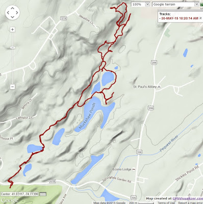
When I called the Nature Conservancy to see if they had a PDF file of the map since all I could find online was a blurry picture on a geocaching site, I was told there are maps at the trailhead. As much as I NEVER count on that, I took my blurry copy and went anyway, with backup hikes in mind, just in case. Indeed, the kiosk was well-stocked with maps but you should never assume that will be the case. Besides, how can you plan your hike without a map? So here you have it! By the way, dogs are not allowed in the preserve but I did not know that until I got home and had a chance to read the brochure. There was nothing at the preserve (see sign above) or online that said no dogs, it's only in the brochure.
HIKE DISTANCE: 5.9 miles
THE HIKE:
 |
| Across the street from the Whittingham WMA parking lot, the trailhead for Muckshaw Ponds Preserve. |
 |
| The start of the red-blazed Sink Hole Pond Trail with a kiosk a few steps in. |
 |
| Some short, steep sections early on. |
 |
| An abundance of wildflowers everywhere in the preserve. |
 |
| A sink hole down below. |
 |
| A little tree frog! Had he not been at eye level right off the trail I would have never seen him. |
 |
| The yellow-blazed Upper Woodland Trail. |
 |
| This sign was 1.55 miles into the hike and it says 0.8 miles to the Whittingham parking area where I just came straight from? |
 |
| A way in on the Upper Woodland Trail, things start to get a little dicey. As you can see on my track, I went straight because I could not find the turn and ended up in a field. I looked and looked and finally saw where the trail enters the woods but there are blow downs and it is overgrown so it's hard to find. |
 |
| Very overgrown. |
 |
| Again confusing at the Cascade Trail. I saw nothing so I ended up on a woods road but there were no markers so I retraced back to the sign. |
 |
| Then after much searching I found it. See the orange marker in the upper right of the picture on the tree? It's not easy to see and the trail is again overgrown and obstructed with blowdowns. |
 |
| The trail finally comes out onto a clear woods road. |
 |
| No cascades here. |
 |
| This is definitely where they should be but they are dried up. |
 |
| Continuing on... |
 |
| ... the yellow trail left the woods road into even thicker overgrowth. Not wanting to deal with that I remembered that woods road I had taken before I found the Cascade Trail. |
 |
| So we turned back and stayed on the woods road and ... |
 |
| ... followed along with the GPS until ... |
 |
| ... we met up with where we turned around previously. This woods road would take us back to the yellow trail with no overgrowth and blowdowns. |
 |
| Back on the yellow Upper Woodland Trail. |
 |
| Went wrong here because it was too easy to follow the woods road when the turn off of the woods road is all overgrown but when there were no blazes, turned back and found the trail. |
 |
| Coming up on Big Muckshaw Pond. |
 |
| But a little more overgrowth first. |
 |
| At this sign on the left a branch of the red Sink Hole Trail goes right but there are no markers or signs. That was the return route but I wanted to go to the Big Muckshaw Overlook first. |
 |
| And here it is off of a blue side trail. |
 |
| I wanted to go to the white Seasonal Pond Loop but to get there we had to go through yet more overgrowth. |
 |
| This is her "Please can we not go this way I have had it with overgrowth" look. So we turned back and skipped the white trail. |
 |
| Made that turn on to red on a woods road that goes between two ponds. |
 |
| Sorry, more overgrowth this way, too. |
 |
| But once back on the main part of the red trail where we were retracing all was clear. That seems to be the most used section of trail. |
 |
| Leaving the preserve back to the car. |


