ABOUT THE PARK:
Sam's Point Preserve - The Nature Conservancy
Sam's Point Preserve Trail and Hiking Information - The Nature Conservancy
Sam's Point Preserve - Open Space Institute
DIRECTIONS:
GPS Coordinates 41.670161, -74.361735
View Larger Map
 |
| Sam's Point Preserve Parking Lot |
- $10 parking fee - worth every penny
- parking lot opens at 9 am - get there early to get a parking spot!
- most people will be at Ice Caves and falls; lots of solitude and views going to High Point
- virtually no shade throughout the entire hike - bring lots of water, not good for a hot day
- 2 ladders in the ice caves will most likely be a problem for dogs
- trails connecting to Minnewaska State Park currently CLOSED (10/8/11)
TRAIL MAPS:
Shawangunk Trails Map #104 - NY/NJ Trail Conference
HIKE DISTANCES:
Sam's Point/Ice Caves/Verkeerder Kill Falls/High Point Loop with Indian Rock - 10.6 miles
Sam's Point/Ice Caves/Verkeerder Kill Falls/High Point Loop - 9.6 miles
Sam's Point/Ice Caves/Verkeerder Kill Falls Out and Back - 7.3 miles
Sam's Point/Ice Caves Out and Back - 3.75 miles
PEAK BAGGING:
High Point - Peakery.com
THE HIKE:
 |
| View of Sam's Point from the Trailhead |
 |
| The trailhead is to the left of the conservation center - take the right fork to Sam's Point. |
 |
| Follow the aqua-blazed Long Path (Loop Road on the map) to Sam's Point. |
 |
| A view of High Point Monumnent in New Jersey along the way. |
 |
| Sam's Point |
 |
| The conservation center and parking lot from Sam's Point. |
 |
| View north from Sam's Point. |
 |
| Continue on to the Ice Caves Loop Trail. |
 |
| One of the ladders along the Ice Caves Loop Trail. |
 |
| After the ice caves, continue on to Verkeerder Kill Falls. |
 |
| The Verkeerder Kill Falls Trail, still the aqua-blazed Long Path, offer continuous views heading towards Minnewaska State Park. |
 |
| Sign at the top of Verkeerder Kill Falls. |
 |
| Cross over Verkeerder Kill Falls at the top. |
 |
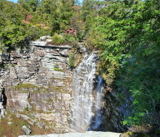
| View of Verkeerder Kill Falls from a side path to the right. |
 |
| The red-blazed High Point Trail has many short rock scrambles along the way. |
 |
| High Point Trail |
 |
| High Point Trail |
 |
| Views from High Point Trail |
 |
| High Point Benchmark |
 |
| Views of the Catskills from High Point |
 |
| Old fire tower footings at the start of the BerrypickerTrail (currently closed) |
 |
| Boards over swamp on Indian Rock Trail. |
 |
| Views from Indian Rock Trail |
 |
| Indian Rock on the left - from this point the trail turns left and descends through a very narrow rock crevice to get to Indian Rock. |
 |
| Indian Rock |
 |
| Lake Maratanza from side trail off of Loop Road |
 |
| Loop Road |
 |
| Fall foliage along Loop Road |
 |
| Old berry picker shack |
HIKE SUMMARY:
[ 0.00] Take aqua-blazed Long Path (Loop Road on park sign) right fork of trail to left of conservation center towards Sam's Point
[ 0.70] Short side trail to left to Sam's Point
[ 0.85] Retrace and continue on aqua-blazed trail
[ 1.35] Right at fork towards Ice Caves when Loop Road continues to the left
[ 1.40] Keep straight when Verkeerder Falls Trail (aqua-blazed Long Path) goes left
[ 1.65] Turn right down steps to Ice Caves
[ 2.10] Back at beginning of Ice Cave Loop - keep straight
[ 2.40] Turn right on Verkeerder Falls Trail (aqua-blazed Long Path)
*** keep straight and return to parking lot for 3.75 mile hike ***
[ 3.80] Enter private property at Leave No Trace sign
[ 3.90] Rock hop over top of falls, look for side trails to right for view of falls
*** retrace back to parking lot for 7.3 mile hike ***
[ 4.00] Left on red-blazed High Point Trail
[ 6.20] High Point; continue on red-blazed trail
[ 6.65] Red trail ends; keep straight on blue briefly to views at old fire tower footings; retrace
[ 6.75] Turn right on .1 mile connector trail to High Point Carriageway
[ 6.85] Left on High Point Carriageway
[ 8.00] Right on yellow-blazed Indian Rock Trail
*** continue straight to return to parking lot for 9.6 mile hike ***
[ 8.50] Indian Rock after trail turns left and descends through narrow rock crevice; retrace
[ 9.00] Right on High Point Carriageway
[ 9.30] Towers on right
[ 9.40] At T-intersection turn right on Loop Road
[ 9.50] Side trail to Maratanza Lake, retrace
[10.25] Ruins of berry picker shacks begin on right
[10.60] Back at parking lot


