ABOUT THE PARK:
Big Pocono State Park - Pennsylvania DCNR
Although the park closes from mid-December until spring, a volunteer I spoke with indicated this applies to driving up the mountain on Camelback Road to park at the summit. Following the parking directions for this hike, you may access the park for snowshoeing in the winter. You might want to confirm before heading out - see park link above for contact info. At the present time there is no hunting on Sundays in Pennsylvania.
DIRECTIONS:
These directions are to Riday's Gate, a small parking lot at the southern base of Camelback Mountain where this hike begins, not the main parking lots at the top of the mountain.
View Larger Map
TRAIL MAP:
Big Pocono State Park Map - Does not show all of the trails for this hike
USGS Topo Map - type "Tannersville, PA" into the search bar and follow directions to download that section of the map - this is the map used in the illustration below.
HIKE DISTANCE:
Full loop - 9.55 miles
Shortened Loop - 8.00 miles
HIKE DESCRIPTION:
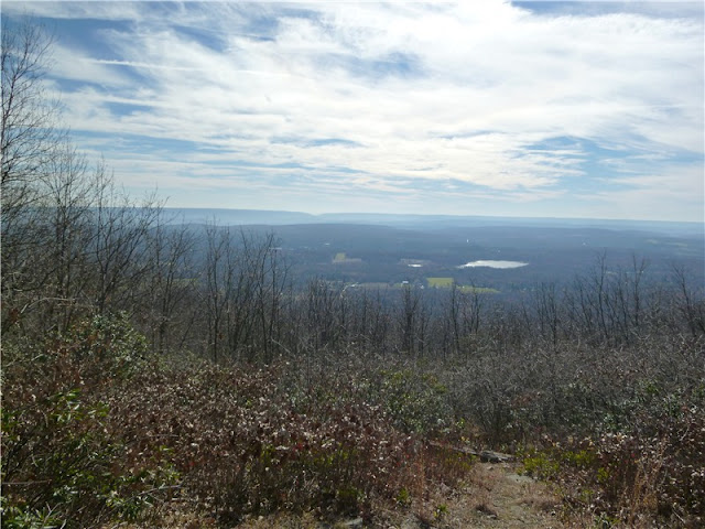
This hike, only 15 minutes west of the Delaware Water Gap, has sweeping views of the entire Kittatinny Mountain range to the east. You can envision the Appalachian Trail winding it's way through and you might recognize areas you have hiked along that mountain range. Although views would be great at any time, when the leaves are down you get to enjoy the views throughout most of the hike.
The hike starts on the old railroad grade at Riday's Gate. This is a blue-blazed trail that is not on the state park map and is not maintained by the park (I believe it is maintained by the Pocono Outdoor Club) but other than a few wet areas, the trail was in great shape. Hiking along the railroad grade is very pleasant - it's flat, takes you up high above the forest floor providing sweeping views of the forest, through rock walls and rhododendron tunnels.
 At the intersection with the trail register at 1.1 miles, keep straight as the railroad grade becomes the red-blazed North Trail Lower Loop, which is shown on the park map. You'll be returning to this intersection via the trail to the left at the end of the hike.
At 1.9 miles the red-blazed North Trail Lower Loop makes a sharp left turn - if you miss the turn you will know within a very short time as you will reach the no trespassing zone of the Camelback Ski Corporation. Although the railroad grade continues across the ski slopes into State Game Lands 38 on the western side of the mountain, you may not pass through the ski area.
After the sharp left turn, the red-blazed trail starts to climb. At 2.1 miles the red-blazed trail becomes the North Trail at a right turn where it will ascend very steeply but there are no rock scrambles. Where you started out at around 1,200 feet elevation, you will be ascending to the summit of Camelback Mountain at 2,132 feet.
At 2.8 miles turn right on the orange-blazed trail which will soon bring you to Rim Road at a clearing on the right with a picnic table, bench and view to the north.

Cross Rim Road and continue on a gravel path to Parking Lot #4. Cross the parking lot and continue on the path to the right of the picnic area. A few trails will cross over - these lead to restrooms and back over to Rim Road. You can turn off to explore here or continue straight on the path which brings you to Parking Lot #2 with views on both sides. You will literally feel like you have arrived at the top of the world.
Straight ahead is a kiosk which was stocked with park maps at the time I was there.

Just beyond the kiosk is the Cattell Cabin.
To shorten the hike to 8 miles, return to the kiosk and face the restrooms. Take the trail to the left of the restrooms which will bring you to Parking Lot #3. Veer to the right through the parking lot, walking out the entrance; cross over Rim Road and follow the sign for South Trail. This will put you on the yellow-blazed Vista Trail with a very touching memorial a short distance ahead on the right.
At the end of the Vista Trail, turn left on the South Trail to the vista then continue from *** below, subtracting 1.55 miles from the mileage to the end of the hike.
To continue on the 9.55 mile hike, proceed past the Cattell Cabin on to Camelback Road.

At 3.5 miles pass a State Forest helipad on the left with views to the south and southwest.
At 3.7 miles pass a yellow metal gate and the road to Camelback Restaurant on the right.
 |
| View from Camelback Road |
At 4.0 miles pass another yellow metal gate on the left and start watching for a gravel trail blocked by a boulder to the left shortly after the gate. Turn left here on the yellow-blazed South Trail. At an intersection at 4.3 miles, turn left. Although the South Trail is very easy to follow, don't worry if you do not see yellow blazes because there are hardly any. An old sign on the left at 4.85 miles will reassure you that you are on the right trail.
*** At 5.2 miles the Vista Trail comes in from the left. The vista is a few steps ahead on the South Trail at a boulder on the right.
 |
| Wind Gap, PA where the Appalachian Trail runs along the ridge. |
Continue east on the South Trail. The Scout Trail, a very new trail (ran into the young man who built the trail for his scout project doing a final inspection) comes in from the left at 5.6 miles. The Scout Trail takes you back to Rim Road.
A few steps ahead on the South Trail brings you to views of the Delaware Water Gap with Mount Tammany on the left and Mount Minsi on the right.
At 5.85 miles arrive at an intersection. Keep straight on the orange-blazed Indian Trail which is a 1-mile loop that will bring you back to this intersection.
At 6.25 miles the Indian Trail veers to the left while short side trails to the right bring you to ledges (with steep drops) and incredible views.
 |
| The Kittatinny Mountains and the Delaware Water Gap |
 |
| Firecracker debris from the vista packed out by my dog in her backpack. |
When the Indian Trail comes to a bench at an intersection at 6.75 miles, turn left.
This leads you to the intersection where the orange-blazed Indian Trail began. Keep straight on the South Trail which will switchback down steeply at times.
 |
| The South Trail descends with views to the east and southeast. |
The South Trail ends at 7.9 miles. Turn right on the red-blazed North Trail Lower Loop. At 8.25 miles, keep right at a fork. At 8.4 miles the red-blazed North Trail Lower Loop veers left at the trail register. Turn right on the blue-blazed old railroad grade to return to the parking lot at 9.55 miles.
HIKE SUMMARY:
9.55 Mile Hike:
[ 0.00] From Riday's Parking Lot take the blue-blazed old railroad grade
[ 0.30] Cross over yellow metal gate
[ 1.10] Straight on red-blazed North Trail Lower Loop at trail register intersection
[ 1.90] Red-blazed North Trail Lower Loop makes sharp left turn
[ 2.10] Turn right at intersection on red-blazed North Trail; ascend more steeply
[ 2.50] Keep right at fork; trail switchbacks up
[ 2.60] Keep right at intersection; keep left at fork short distance ahead
[ 2.80] Turn right on orange-blazed trail at end of North Trail
[ 2.90] Cross Rim Road continuing on gravel path
[ 3.15] Arrive at summit at Parking Lot #2
[ 3.35] Cattell Cabin - continue straight to Camelback Road
[ 3.50] State Forest helipad on left
[ 3.70] Pass yellow metal gate and Camelback Restaurant on right
[ 4.00] Pass yellow metal gate on left; turn left on gravel South Trail
[ 4.20] Trail register on right
[ 4.30] Turn left at intersection; right goes to State Game Lands 38
[ 4.85] Old South Trail sign on left
[ 5.20] Vista trail comes in from left; vista ahead on right at boulder
[ 5.60] Scout Trail comes in from left; views of Delaware Water Gap on right
[ 5.85] At intersection proceed straight on orange-blazed Indian Trail
[ 6.25] Trail goes left while multiple side trail to the right go to views along ledges
[ 6.75] Turn left at intersection by bench; keep straight on South Trail ahead
[ 7.90] Turn right on red-blazed North Trail Lower Loop at end of South Trail
[ 8.25] Stay right at fork
[ 8.40] Turn right on blue-blazed old railroad grade where red-blazed trail turns left
[ 9.25] Cross yellow metal gate
[ 9.55] Arrive back at Riday's Gate parking area
8 Mile Hike
[ 0.00] From Riday's Parking Lot take the blue-blazed old railroad grade
[ 0.30] Cross over yellow metal gate
[ 1.10] Straight on red-blazed North Trail Lower Loop at trail register intersection
[ 1.90] Red-blazed North Trail Lower Loop makes sharp left turn
[ 2.10] Turn right at intersection on red-blazed North Trail; ascend more steeply
[ 2.50] Keep right at fork; trail switchbacks up
[ 2.60] Keep right at intersection; keep left at fork short distance ahead
[ 2.80] Turn right on orange-blazed trail at end of North Trail
[ 2.90] Cross Rim Road continuing on gravel path
[ 3.15] Arrive at summit at Parking Lot #2
[ 3.35] Cattell Cabin - return to kiosk, face restroom, take trail to left of restrooms
[ 3.45] Veer right through Parking Lot #3, walk out entrance, cross Rim Road; take yellow-blazed Vista Trail to South Trail
[ 4.05] Scout Trail comes in from left; views of Delaware Water Gap on right
[ 4.30] At intersection proceed straight on orange-blazed Indian Trail
[ 4.70] Trail goes left while multiple side trail to the right go to views along ledges
[ 5.20] Turn left at intersection by bench; keep straight on South Trail ahead
[ 6.35] Turn right on red-blazed North Trail Lower Loop at end of South Trail
[ 6.70] Stay right at fork
[ 6.85] Turn right on blue-blazed old railroad grade where red-blazed trail turns left
[ 7.70] Cross yellow metal gate
[ 8.00] Arrive back at Riday's Gate parking area


