Saturday, June 5, 2010
Tourne County Park (Morris County, NJ)
ABOUT THE PARK: Morris County Park Commission
TRAIL MAP: Downloadable maps - saw no maps at all available at the park.
PARKING DIRECTIONS:
Boonton Side: From the Morris Country Park Commission website - this area is heavily used and when I was there McCaffrey Lane was being closed off for a 5K race.
Denville Side: McCaffrey Lane is gated in the middle of the park so there is no through traffic to the other side. Instead of turning left from Fanny Road on to McCaffrey Lane, continue straight and turn left on Old Denville Road. The park entrance will be on the left. This parking lot is by the children's play area, is very large and appears to be lightly used.
HIKE DIRECTIONS:
The weather forecast for the weekend was not good with a constant chance of thunderstorms so I wanted a park where I would have a quick out back to the car if needed. Turned out to be a sunny day but terribly hot and humid. Managed to get 9.5 miles in exploring the trails with repeating some trail sections. I was not able to find trail distances online so I measured the ones I was on and will provide approximate trail lengths.
DeCamp Trail to Top of the Tourne - 1.5 mile loop, unmarked
This should be a view of the New York City skyline but with the haze and humidity the skyline was not visible the morning I was there:
Red-Blazed Trail - 3 miles
Appears to be the most heavily used trail in the park
White-Blazed Trail - 1 mile
Not as heavily used as the red-blazed trail.
Along the white-blazed trail there is a sign for Boiling Spring. I turned at the sign and followed the unmarked trail but it kept forking into other unmarked trails not on the map, there were no more signs and I never did find Boiling Spring.
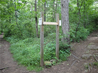
Swamp Trail
Apparently this trail no longer exists as it goes right into the swamp. There is no way to the other side that is supposed to come out on to the red-blazed trail.
Swamp Trail trailhead from white-blazed trail:
Mountain Lakes/Birchwood Trail - umarked - .8 miles (in pink on map)
Unmarked Trails
There are several unmarked trails, more than what is shown on the map, so it is confusing to know exactly where they lead. Although the unmarked trails are well-defined and not overgrown, I did not run into any other people.
LITTER REPORT:
No litter! Noticed most people using reusable water bottles instead of disposable plastic bottled water.
Sunday, May 30, 2010
Black River County Park (Morris County, NJ)
ABOUT THE PARK:
The Black River County Park consists of trails (mainly the Patriot's Path) connecting 4 cultural sites and Chubb Park:
- Cooper Gristmill
- Kay Environmental Center
- Bamboo Brook Outdoor Education Center
- Willowwood Arboretum
TRAIL MAP:
Morris County Parks Black River Trail Map
I stopped by and picked up my map from the parking lot kiosk at Cooper Gristmill over the winter when I was in the area doing another hike. Today there were no maps so be sure to print one out.
PARKING DIRECTIONS:
Morris County NJ Park Commission Web Site Directions
Looking at the map, you will see many other parking options. When I arrived at Cooper Gristmill the parking lot entrance was still chained but there is paved roadside parking along Route 513 in front of the parking lot, which is where I parked.
HIKE DIRECTIONS:
I hiked 12 miles total out and back but you are able to hike any distance you would like.
6.4 mile NY/NJ Trail Conference version
14.8 mile NJ Hiking version
My hike was blue-blazed Black River Trail to red-blazed Conifer Pass Trail to blue-blazed Bamboo Brook trail to just beyond where the trail stops following the brook, then turned around and headed back. On the way back we explored an unmarked trail and the green-blazed trail. Returning to Cooper Mill we went through the tunnel to head north on the blue-blazed Black River Trail to Chubb Park and back.
Descend the stairs from behind the stone gristmill to head south on the blue-blazed Black River Trail.
Kay's Pond:
Red-Blazed Conifer Pass Trail (beautiful hike down into the river gorge): (The NY/NJ Trail Conference mentions obtaining a pass at Kay Environmental Center to hike this trail. I could not do that since I could not take my dog there to get a pass, I did not see any signs saying a pass was needed and this is not mentioned on the park website or on the map so the pass requirement information might be outdated.)
Blue-Blazed Bamboo Brook Trail:
Unmarked trail at north end of red-blazed Conifer Pass Trail:
Green-blazed Trail:
Blue-Blazed Black River Trail north of Cooper Mill to Chubb Park:
LITTER REPORT:
Other than a piece of ribbon and part of a candy wrapper, picked up nicotine gum somebody must have dropped accidentally. Very clean trails!
Sunday, May 23, 2010
Harriman State Park, NY via Kakiak County Park, NY
ABOUT THE PARK:
Harriman State Park
Kakiak County Park
TRAIL MAP: NY/NJ Trail Conference Harriman Bear Mountain Trail Map #118
PARKING DIRECTIONS: US 202 north of Suffern, NY
DISTANCE: 13 miles (many shorter options possible)
HIKE DIRECTIONS:
As you pull into Kakiak County park you will notice a gate blocking off the road to the left. This is the road you will walk after parking to access the trail heads.
Walk over the bridge and straight ahead to the orange-blazed Mountain trail:
At .6 miles take a short unmarked trail to the right to a scenic overlook:
Backtrack and continue on the orange-blazed trail.
At 1.5 miles turn left on the white-blazed trail.
At 3.2 miles turn left on the black dot on white-blazed trail.
At 4 miles turn left on the orange-blazed trail. I went to the first overlook, which was disappointing as the scenery is marred by huge buildings and power facilities (I am guessing that is what all of that is...)
Backtrack and turn left on the the black dot on white-blazed trail at 4.7 miles.
View from the black dot trail: (It was a hazy morning so the pictures are not the best.)
At 5.4 miles turn right on the blue-blazed trail. There is a very steep and long rock scramble section on this trail that my dog had some difficulty with but I managed to get her up. After that point, great panoramic views.
At 6.8 miles the orange-blazed trail joins the blue-blazed trail briefly but I only saw orange blazes, which was confusing. Do stay straight anyway and the orange trail will veer off shortly and you will still be on the blue trail.
At 7.4 miles turn right on the white trail.
At 7.7 miles turn left on the black trail.
At 8.2 miles turn left on the yellow trail.
At 8.3 miles turn right on an unmarked woods road.
You will be able to see Pine Meadow Lake
At 8.6 miles keep to the left at the fork in the woods road.
You will start to notice old concrete foundations to the right. Shortly past that there will be a stone wall with a cairn on the top close to the woods road. Turn right on that unmarked trail at 8.8 miles. Initially, the trail will be quite ugly and you have to walk along rusty old pipes:
Eventually you do leave those awful pipes behind and the trail becomes quite pretty with views of the lake.
At 9.4 miles turn right on the white-blazed trail.
At 9.9 miles turn right on the yellow-blazed trail.
Along the yellow-blazed trail you will be able to see the New York City skyline:
At 11.2 miles turn left on the white-blazed trail.
This will take you back through Kakiak County park to the parking lot at 13 miles.
LITTER REPORT: Not too bad except for tons of white tissues scattered all along the trails which I simply will not pick up. (YUK!)
Subscribe to:
Posts (Atom)