

ABOUT THE PARK:
Castlewood State Park - Missouri Department of Natural Resources
DIRECTIONS:
GPS Coordinates 38.552409, -90.542942
 |
| First parking lot next to the park office. There are more parking lots farther in. |
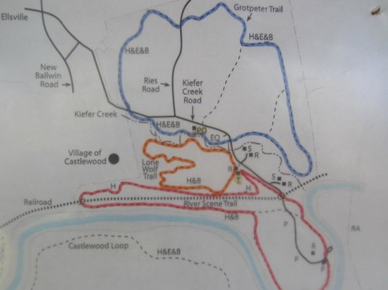
TRAIL MAP:
Park Trails at Castlewood State Park - Missouri Department of Natural Resources
This photo of Castlewood State Park is courtesy of TripAdvisor
Powered by Wikiloc
HIKE DISTANCE: 8.8 miles
THE HIKE:
My very first hike was in this park - 35 years ago.
 |
| At the kiosk at the far end of the parking lot, we took the blue Grotpeter Trail to the right. |
 |
| Kiefer Creek on the left. |


 |
| Crossing Kiefer Creek Road |


 |
| Crossing Ries Road. |


 |
| Carolina Wren |

 |
| Brodie notices something up ahead. |
 |
| We waited. She would not move. We inched forward and she flicked her tail up and started stomping her front hooves. So we bushwhacked off trail to the left around her. |
 |
| Turns out she would not run because she was worried about the deer to our left. We moved through at a respectful distance and all was well. |
 |
| Now what has Brodie found? |
 |
| Can't blame him for hiding from Brodie when Brodie has turtle soup on his mind. |

 |
| When blue comes out on Kiefer Creek Road ... |
 |
| ... left across the bridge then right to ... |
 |
| ... the yellow-blazed Lone Wolf Trail. |


 |
| Views of the Meramec River from the top. |
 |
| We then went left on yellow/red for more views. |


 |
| Red ends up back on Kiefer Creek Road where it turns right ... |

 |
| ... goes under the bridge ... |
 |
| ... then left into the woods. |
 |
| Now the trail follows along the Meramec River with many side trails down to the river bank. |


 |
| A white-throated sparrow and a cardinal eating berries. |

 |
| The red trail goes under the railroad tracks ... |
 |
| ... then up endless flights of steps. |


 |
| Views near the top. |


 |
| Left on yellow. |


 |
| Back to the blue Grotpeter Trail ... |

 |
| ... to the parking lot. |