Sunday, December 4, 2011

Appalachian Trail: Warwick Turnpike, NJ to Prospect Rock, NY with Cascade Lake Park, NY


ABOUT THE PARK:
Cascade Lake Park - Town of Warwick, NY
Appalachian Trail - NY/NJ Trail Conference

DIRECTIONS:
GPS coordinates for parking on Warwick Turnpike:  41.201500, -74.391610

View Larger Map
Roadside parking on both sides of Warwick Turnpike where the Appalachian Trail crosses over. (room for 8-10 cars)
GPS coordinates for parking on Long House Drive (parking not shown on NY/NJ Trail Conference map):  41.195653, -74.371032

View Larger Map
Roadside parking for about 3-4 cars on east side of Long House Drive where AT follows road before crossing over.

TRAIL MAPS:
North Jersey Trail Map #116 - NY/NJ Trail Conference
Warwick Trail Map (Cascade Lake Park) - Town of Warwick, NY
Some notes about the Cascade Lake Park trail map: This park makes a very nice loop in conjunction with the AT but the map appears to be outdated and not very accurate.  The red trail on the map is a woods road with old red blazes.  A newer red-blazed trail is a much more attractive footpath that runs along the banks of Long House Creek on both sides.  At the southern end of the park red blazes are confusing as they lead to a footbridge as well as through a washed out section of woods road at a creek crossing. Stay with the footbridge in that area and ignore the red blazes to the creek as it is not necessary to climb down into the creek and rock hop over.  The orange trail also has yellow blazes initially.  When starting on the loop of the orange trail, make note of where you are as multiple intersections along the loop make it confusing remember which one to take back to the red trail. Never did see the yellow, green or aqua trails. The pink trail appears earlier than it should, then meets back up with the blue trail for a while, disappears, then shows up again farther along the blue trail as a woods road crossing over so it appears to run differently than what is shown on the map.

HIKE DISTANCES:
8.5 miles - park on Warwick Turnpike
6.0 miles - park on Long House Drive
Note:  My hike was 11.8 miles with exploring other trails in Cascade Park Lake so additional mileage can easily be added.

APPALACHIAN TRAIL SECTION HIKING:
TrailHeadFinder.com - AT section miles 1345.2 to 1349.3 (for Warwick Turnpike start)

THE HIKE:
From Warwick Turnpike to Long House Drive, the Appalachian Trail crosses many swamp sections with boards and rock hops.
A creek between Warwick Pike and Long House Drive.
A white blaze of the Appalachian Trail.
A detour of the Appalachian Trail due to the bridge over Long House Creek destroyed by Hurricane Irene.
From the the detour point it would be about 1.2 miles to where the bridge is gone at the creek crossing if you were to stay on the original AT.  However, it is only .05 mile from where the detour meets back up with the AT on the other side.  So I suggest doing what I did - at this point, follow the detour and on the return trip, go on down to where the AT crosses Long House Creek and determine then if you can get across to follow the original AT back at the end of the hike.  If not, you have only gone .05 mile out of your way and can take the detour route back.
Detour along Long House Drive
Detour along paved part of Riverside Drive - residential on right with Long House Creek on left.
Ducks in Long House Creek off of Riverside Drive
Lots of Downy Woodpeckers along Riverside Drive
Riverside Drive becomes a gravel road and continues into Cascade Park beyond where it meets back up with the AT.
Red-blazed trail in Cascade Lake Park following the banks of Long House Creek.
The dam which forms Cascade Lake on Long House Creek.
Cascades spill over the dam at Cascade Lake.
Blue/pink-blazed woods road in Cascade Lake Park.
The blue-blazed trail splits off as a foot path called the Zig Zag Trail and ascends to the Appalachian Trail.
Turn right on the Appalachian Trail to Prospect Rock straight ahead.
From Prospect Rock views of Greenwood Lake, Sterling Forest, NY to the left and NJ to the right.
The AT brings you from New York into New Jersey or you can be in both states at the same time.
A short but steep rock scramble on the AT which some dogs might not find amusing. (She made it down with lots of coaxing and assistance.)
When you reach the detour point keep straight on the AT if you want to take a peak at the creek crossing just over the rise.  This is where the bridge was supposed to be.
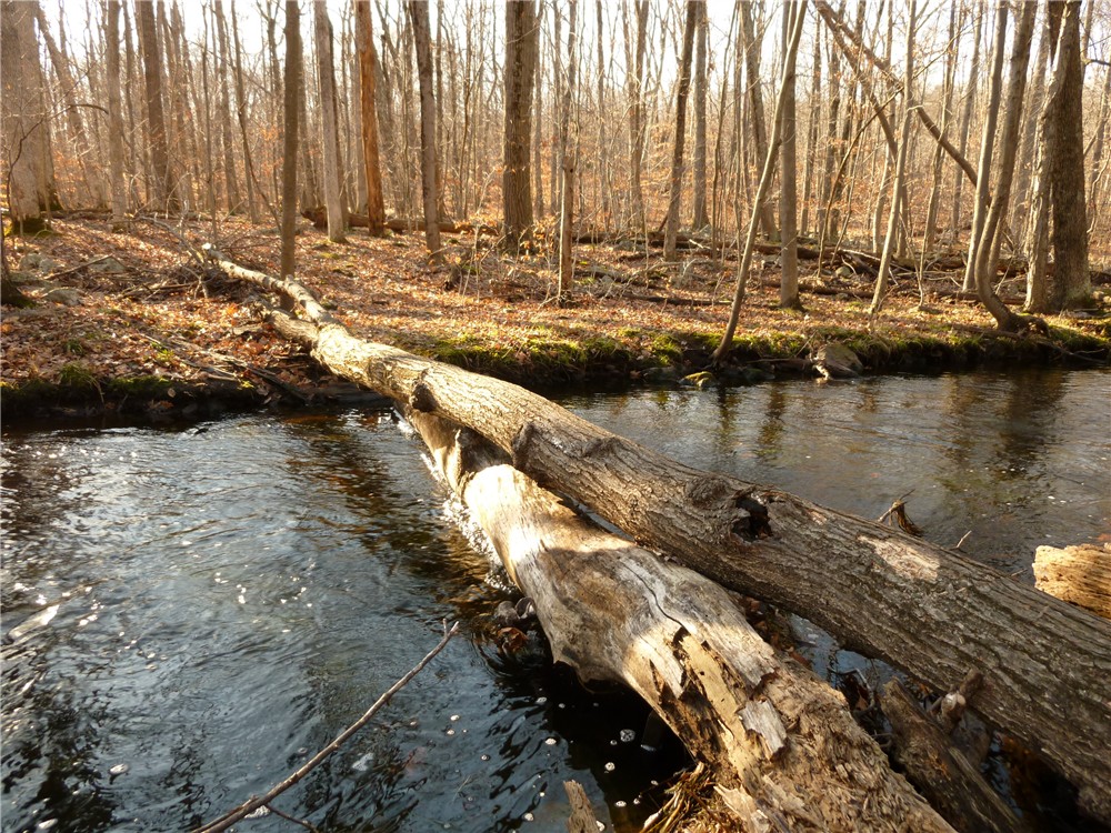
A short distance to the right are a couple of stable logs across the creek.  I did not feel comfortable walking over them (I would have ended up in the creek for sure) so I straddled the logs and scooted over inch by inch. 
From the other side, the broken bridge along the bank of the creek.
The AT will come out at the parking spots on Long House Drive.  If continuing on to Warwick Turnpike, turn left and walk along Long House Drive for .1 mile watching carefully for the AT going into the woods to the right as blazes will keep going straight along the road for the detour portion.  The right turn into the woods will be before the 30 mph curve sign.

HIKE SUMMARY:
8.5 Mile Hike From Warwick Turnpike:
0.00    Head north (east) on AT from Warwick Turnpike roadside parking
0.50    Rock hop over swampy area, boards, bridge over creek
0.65    Cross woods road (not on map)
0.75    Swamp on right, rock hop through wet area, boardwalks
1.15    Boardwalks, rock hop over creek, boardwalks, keep right at fork
1.25    Right on Long House Road
1.80    Turn left on Riverside Drive
2.30    Continue straight when Riverside Drive turns to gravel
2.70    Cross feeder creek with small waterfalls
2.75    Keep straight when AT crosses over
3.05    Turn right on red-blazed trail in Cascade Lake Park; keep straight at footbridge following red-blazed trail along creek bank
3.55    Cascade Lake and waterfalls at dam; left on blue trail beyond waterfalls
3.60    Left on pink, also old green blazes at intersection, blue goes straight, red now gone
3.70    Keep left at intersection
3.75    Cross woods road
3.85    Keep straight when blue joins in from right, not blazed blue/pink
4.10    At fork keep left on blue/pink then keep right when woods road goes left
4.20    At intersection with two woods road, follow blue to left on footpath (well marked)
4.25    Cross woods road blazed pink to the right
4.50    Turn right on white-blazed Appalachian Trail to views at Prospect Rock
4.90    NY/NJ state line and trail register
4.95    Keep straight on AT when blue trail goes left
5.15    Surprise Lake to left as AT turns sharply right
5.20    Keep right on AT when yellow goes left
5.60    Rock hop over creek
5.70    Cross unmarked woods road (not on map)
5.80    Cross unmarked woods road (not on map)
5.85    Back at Riverside Drive gravel road detour, cross over and continue on AT
5.90    If bridge out turn right along bank of Long House Creek to logs that can be used to cross creek then left on other side back to AT
6.45    Cross bridge over creek
6.65    Cross unmarked woods road (not on map)
6.85    AT right right on woods road that comes in from left
6.90    AT leaves woods road to the left
7.05    Turn left on Long House Road at roadside parking
7.15    Cross Long House Road to the right and continue on AT into the woods
7.25    Boardwalks, rock hop over creek, boardwalks
7.35    Keep right on AT at fork
7.85    Cross woods road
8.00    Cross creek on footbridge, cross swamp on boards then rock hop
8.50    Back at car

6.0 Mile Hike from Long House Drive:
0.00    Right on Long House Road
0.10    AT comes in from woods on right
0.75    Turn left on Riverside Drive
1.25    Continue straight when Riverside Drive turns to gravel
1.65    Cross feeder creek with small waterfalls
1.70    Keep straight when AT crosses over
2.00    Turn right on red-blazed trail in Cascade Lake Park; keep straight at footbridge following red-blazed trail along creek bank
2.50    Cascade Lake and waterfalls at dam; turn right on blue-blazed trail (woods road) beyond waterfalls
2.55    Left on pink, also old green blazes at intersection, blue goes straight, red now gone
2.65    Keep left at intersection
2.70    Cross woods road
2.80    Keep straight when blue joins in from right, not blazed blue/pink
3.05    At fork keep left on blue/pink then keep right when woods road goes left
3.15    At intersection with two woods road, follow blue to left on footpath (well marked)
3.20    Cross woods road blazed pink to the right
3.45    Turn right on white-blazed Appalachian Trail to views at Prospect Rock
3.85    NY/NJ state line and trail register
3.90    Keep straight on AT when blue trail goes left
4.10    Surprise Lake to left as AT turns sharply right
4.15    Keep right on AT when yellow goes left
4.55    Rock hop over creek
1.65    Cross unmarked woods road (not on map)
4.75    Cross unmarked woods road (not on map)
4.80    Back at Riverside Drive gravel road detour, cross over and continue on AT
4.85    If bridge out turn right along bank of Long House Creek to logs that can be used to cross creek then left on other side back to AT
5.40    Cross bridge over creek
5.60    Cross unmarked woods road (not on map)
5.80    AT right right on woods road that comes in from left
5.85    AT leaves woods road to the left
6.00    Back at car on Long House Road

Monday, November 28, 2011

Trexler Nature Preserve, Lehigh County, PA


ABOUT THE PARK:
Trexler Nature Preserve - Lehigh County, PA
Texler Nature Preserve - Texler Nature Preserve website
Schlichers Covered Bridge - The Morning Call
Lehigh Valley Zoo - lvzoo.org

DIRECTIONS:
Trexler Environmental Center Parking
GPS Coordinates 40.655541, -75.614718

View Larger Map

TRAIL MAP:
Trexler Nature Preserve Map
This is a PDF file of the map in GoogleDocs.  Click the "Download Original" button in the upper right corner to save to your PC so you can enlarge and print.  There are many kiosks throughout the park but most map holders are empty.

HIKE DISTANCE:  8 miles

PEAK BAGGING:
Mill Hill - Peakery.com
Schantz Hill - Peakery.com

THE HIKE:
Click here for a written description.

Head towards the Trexler Environmental Center with views of the rolling hills of Pennsylvania along the way.
Even if the Environmental Center is closed, an outside ramp leads to a rooftop deck for more views.
Roof top views from the Trexler Environmental Center.
Expect similar views throughout most of this hike.
The teal-blazed Trexler Nature Trail to Jordan Creek Ford.
The double blue-blazed Elk Viewing trail at kiosk #15.
Elk in the field to the right of the blue-blazed Elk Viewing Trail.
At the top of the blue-blazed Elk Viewing Trail at a picnic table, a view of the Lehigh Valley Zoo below.
The original Schlichers Covered Bridge built in 1882 to be replaced with a replica in 2013.
Inside Schlichers Covered Bridge, closed to traffic since 2009.
Rock hop over a feeder stream to the white-blazed Fireman's Trail from Schlichers Covered Bridge - rocks are about an inch under water so be sure to wear waterproof hiking shoes!
A view of Jordan Creek from above after ascending the white-blazed trail.
Hiking over hilltop meadows.
The green-blazed Teardrop Trail
Hiking along turnip (?) fields.
The yellow-blazed Hunsicker Valley Trail along an old roadbed.
The red-blazed Trexler Border Trail.
Panoramic views on the red-blazed trail in the northwestern corner of the preserve with the Blue Mountain on the horizon, atop which runs the Appalachian Trail.
Horses on the red-blazed Trexler Border Trail.
The red-blazed Trexler border trail touches on the corner of the bison area but you will most likely need to leave the trail and walk paved park roads to where the bison are.
They don't budge when people (or dogs) pass by.


HIKE SUMMARY:
[  0.00]    Follow gravel road to Environmental Center crossing over red-blazed Border Trail
[  0.15]    Rooftop views at Environmental Center; retrace to red-blazed Trexler Border Trail
[  0.25]    Turn right on the red-blazed Trexler Border Trail and keep straight when double teal-blazed trail comes in from right
[  0.30]    Turn right on teal-blazed trail at bottom of hill as the red trail bends to the right
[  0.65]    Cross paved road, rock hop over creek, veer left
[  0.75]    At paved area at Jordan Creek and bridge, turn right on double blue blazed trail keeping right uphill beyond kiosk #15
[  1.05]    Watch for various unmarked side trails to the right for elk viewing depending on where elk are
[  1.45]    Keep left on double blue before wooden fence at park road to picnic table and bench with view of zoo below; continue on double blue to left at kiosk #13
[  1.60]    Keep straight on double blue when pink (not on map) goes right
[  2.05]    Double blue trail switchbacks down to covered bridge on right and pedestrian bridge on left; turn right leaving double blue trail, cross road in front of covered bridge, hop guardrail and rock hop over creek; continue left on white-blazed trail at kiosk #9
[  2.35]    Turn left on orange-blazed trail when the white-blazed trail ends at T-intersection
[  2.60]    Turn left on green at kiosk
[  2.65]    View to the left
[  2.70]    Make sharp right turn on green at kiosk #4 when green also goes to the left
[  2.85]    Keep straight on green at kiosk #5 when blue goes left
[  2.90]    Come out on mountaintop meadow keeping straight on green with the other side of the green trail comes in from the right
[  3.10]    Keep straight on green at kiosk #2 when orange comes in from the right
[  3.35]    Keep straight on green when green/white (on map, only a green blaze on trail) goes left at kiosk #1
[  3.75]    Turn left on red at kiosk #7 when green ends
[  3.80]    Turn left on yellow as red goes right
[  3.85]    Keep left at unmarked fork (not on map)
[  4.25]    Turn right on red at kiosk #6; rock hop over creek
[  4.95]    Panoramic view at top of ascent at bench
[  5.25]    Keep left on red when yellow goes right
[  5.30]    Keep straight on red at kiosk #7 when green goes right
[  6.05]    Keep straight on red when white comes in from right; cross paved road and continue on trail parallel to road
[  6.20]    Follow red trail on paved park road to the right between two pillars at kiosk #11
[  6.40]    Red trail leaves paved road to the left
[  6.75]    Red trail comes out on paved road at corner of bison area, turn right on paved road continuing beyond camping area to view bison; retrace to red trail
[  7.30]    From paved road continue back on red trail as it veers left at a small brown building
[  7.35]    Keep left on red at unmarked fork (not on map)
[  7.70]    Keep straight on red as unmarked woods road goes right (not on map)
[  7.95]    Keep straight on red as double teal trail goes right; at gravel road turn left to parking lot
[  8.00]    Back at parking lot

NOTE:
I had intended to do this hike a little differently but ran into a snag and had to reroute so you might want to avoid this section of trail.  The red-blazed Trexler Border Trail crosses over Jordan Creek below kiosks #4 and #3 on the left side of the map.  Although the trail continues on the other side, it is not possible to ford the creek.  The water looked to be at least waist deep, if not deeper in the middle. 

Thursday, November 24, 2011

Harriman State Park, NY - Cranberry Mountain and ORAK Ruins


ABOUT THE PARK:
Harriman State Park - The Palisades Parks Conservancy

DIRECTIONS:
GPS Coordinates 41.229714, -74.060327

View Larger Map
Parking on Route 106

TRAIL MAP:
Southern Harriman Bear Mountain Trails Map #118 - NY/NJ Trail Conference

HIKE DISTANCE: 
9.6 miles
Click here for a shorter 4.5 mile version.

PEAK BAGGING:
Cranberry Mountain - Peakery.com
Big Hill - Peakery.com
Jackie Jones Mountain - Peakery.com
Breakneck Mountain - Peakery.com 

THE HIKE:
Facing the road from the parking lot, turn left, walk up Route 106 briefly, cross bridge then turn left on the paved roads and go beyond the gates at the yellow blazes.
ORAK Manion Ruins - Summer home of a former VP of the company that makes Karo Syrup built in 1923 (ORAK = KARO spelled backwards)
The aqua-blazed Long Path approaching Big Hill.
Big Hill Shelter built in 1927.
New York City skyline from the Big Hill shelter.
Camp Lanowa cabins at Breackneck Pond.  Camp Lanowa is a summer camp for inner city kids.
Breakneck Pond dock at Lake Lanowa
Tuxedo-Mt. Ivy Trail connecting to the yellow-blazed Buck Trail.
Cranberry Mountain Trail
Top of Cranberry Mountain off of unmarked side trail
Breakneck Pond from Cranberry Mountain.  The white-blazed Breakneck Mountain trail runs along the ridge on the other side of Breakneck Pond.
Turn left on an unmarked trail before this intersection to connect to the aqua-blazed Long Path.
Yellow-blazed Suffern-Bear Mountain Trail to Jackie Jones Mountain.
Jackie Jones fire tower built in 1928.

HIKE SUMMARY:
[  0.00]  Left on Rt. 106 over bridge, left on paved road beyond gates on yellow-blazed trail
[  0.20]  The yellow trail veers left on the fork of a more narrow paved drive beyond boulders
[  0.35]  ORAK mansion ruins
[  0.80]  Turn left on unmarked woods road when the yellow trail turns right on the woods road
[  1.05]  At T-intersection with #712 on sign turn left
[  1.15]  As the woods road veers right at bottom of hill, turn right on aqua-blazed Long Path
[  1.20]  Rock hop over creek
[  1.90]  Yellow joins in from the right; follow aqua and yellow combined
[  2.00]  Big Hill Shelter with views; continue on yellow only on the other side of the shelter
[  2.70]  Third reservoir visible on left
[  2.85]  After long bare rock surface, yellow scrambles down to the left, at bottom when yellow turns left, turn right on white-blazed trail which then follows the left fork (white blazes may be faded and hard to see)
[  2.90]  Turn right on unmarked trail then left at fork
[  3.05]  Camp Lanowa and Breakneck Pond; retrace
[  3.25]  Watch for unmarked trail on right to reconnect to white trail, turn right on white
[  4.50]  At end of white trail, turn right on white with red line trail
[  4.55]  Right on woods road at two cairns
[  4.65]  Woods road comes out at clearing after swampy area, turn left on yellow-blazed trail
[  5.10]  Turn right on yellow with black diagonal line-blazed trail when yellow goes left
[  5.40]  Rock hop over creek
[  5.50]  Turn left on woods road when yellow with black diagonal line trail ends
[  5.70]  When woods road turns left, turn right on woods road lined with boulders on left which is Cranberry MountainTrail
[  6.45]  Just before paved trail comes in on left, turn right on unmarked trail
[  6.65]  Top of Cranberry Mountain to right of large white containers with seasonal view of Breakneck Pond below; retrace
[  6.85]  Right on Cranberry Mountain Trail woods road coming off of unmarked trail, veer right as Cranberry Mountain Trail becomes paved as paved road joins in from left
[  7.10]  Paved trail crosses creek
[  7.15]  Power cut
[  7.20]  Turn left on unmarked trail just before pavement veers right and unpaved woods road goes straight; after a few steps, turn right on aqua-blazed Long Path (hard to see in that direction - as soon as you see an aqua blaze, turn around and follow the trail blazes to the left)
[  7.90]  When the aqua-blazed Long Path crosses a woods road, turn left on woods road
[  8.15]  Turn left on the yellow-blazed trail leaving woods road
[  8.25]  Rock hop over creek
[  8.45]  Rock hop over creek
[  8.70]  Fire tower on top of Jackie Jones Mountain; views near communications tower
[  9.40]  ORAK mansion ruins
[  9.80]  Turn right on Rt. 106 back to parking