Wednesday, October 27, 2010

Sky Meadows State Park, VA


ABOUT THE PARK:  Sky Meadows State Park

DIRECTIONS:

View Larger Map
TRAIL MAP:  Sky Meadows State Park Trail Guide

HIKE DISTANCE:  8 miles

HIKE DIRECTIONS:
From the visitor center parking lot, with the Mount Bleak House behind you, walk across the road towards the kiosk where the hiking trails begin.  Take the gravel road out passing cow pastures on the right where the red-blazed Piedmont Overlook and blue-blazed North Ridge Trails terminate.
When the gravel road turn right, keep straight on the Snowden Interpretive Trail, a 1.14 mile loop.
After completing the loop, continue to the left on the gravel road.  A short distance ahead at 1.60 miles, turn left on the yellow-blazed South Ridge Trail.  At 1.80 miles a short side trail to the right leads to a scenic overlook with a bench.
Backtrack and continue on the yellow-blazed South Ridge Trail arriving at the Snowden Manor Ruins at 1.90 miles.
At 2.15 miles arrive at a bench with scenic views.
Turn left on the blue-blazed North Ridge Trail at 3.00 miles.  Turn right on the white-blazed Appalachian Trail at 3.50 miles.  After a short distance turn left on the purple-blazed Old Trail, the original Appalachian Trail before it was rerouted.  At 5.40 miles arrive back at the white-blazed Appalachian Trail, turn right.
At 6.00 miles turn left on the light-blue blazed Ambassador Whitehouse Trail which leads over meadows with views.
At 7.00 miles turn left on the dark blue-blazed North Ridge Trail briefly then left on the red-blazed Piedmont Overlook Trail and over steps.
At 7.25 miles arrive at the Upper Piedmont Overlook
where the trail descends to the Lower Piedmont Overlook
At 7.80 miles go up and over another series of steps, turn left and down a short flight of steps, then left on the gravel road which lead back to the trailhead.  Arrive back at the visitor center parking lot at 8.00 miles.

HIKE SUMMARY:
[0.00]  From visitor center parking lot cross road to trailhead proceeding up gravel road
[0.40]  Stay straight on Snowden Interpretive Trail when gravel road turns right
[1.50]  Exit Snowden Interpretive Trail; continue left on gravel road
[1.60]  Turn left on yellow-blazed South Ridge Trail
[1.80]  Side trail on right to scenic overlook with bench
[1.90]  Snowden Manor ruins
[2.15]  Bench at scenic overlook
[3.00]  Left on blue-blazed North Ridge Trail
[3.50]  Right on white-blazed Appalachian Trail
[3.58]  Left on purple-blazed Old Trail
[5.40]  Right on white-blazed Appalachian Trail
[6.00]  Left on light blue-blazed Ambassador Whitehouse Trail
[6.40]  Scenic overlook
[7.00]  Left on dark-blue blazed North Ridge Trail
[7.10]  Left on red-blazed Piedmont Overlook Trail
[7.25]  Upper Piedmont Overlook
[7.80]  Go up and over steps, turn left down short flight of steps, left on gravel road
[8.00]  Arrive back at visitor center parking lot

Tuesday, October 26, 2010

Shenandoah National Park, VA - Whiteoak Canyon/Hawksbill Mountain/Cedar Run


ABOUT THE PARK:
Whiteoak Canyon and Cedar Run
Hawksbill Mountain

DIRECTIONS:

View Larger Map

TRAIL MAPS:
Whiteoak Canyon and Cedar Run
Hawksbill Mountain
This map consists of two differently scaled maps pieced together for illustration purposes only.

HIKE DISTANCES:
Whiteoak Canyon/Cedar Run Loop - 8.5 miles
Hawksbill Mountain Loop - 2.9 miles
Whiteoak Canyon/Hawksbill Mountain/Cedar Run - 11.4 miles

HIKE DIRECTIONS:
For this hike I used Trail Blazes, an audio hiking guide that greatly enhanced an already fantastic hike.  I loaded the guide on my iPod which is virtually weightless to take along.  You simply stop and listen at various points along the hike for interesting information you would otherwise not know about where you are, what you are looking at, or what happened in that spot long ago.  The audio is then turned off and you proceed to the next point.  Trail Blazes starts at a different parking lot so for this hike, simply begin the audio at 7.25 minutes for the Whiteoak Canyon Trail then start the audio from the beginning on the Cedar Run Trail.  I prefer to hike uphill early on rather than at the end of a hike so I started this hike at the lowest point, the Whiteoak Canyon parking lot.  Starting from Skyline Drive means you descend first, then climb back up. The total elevation gain for this combined hike was around 3,000 feet.  I did this hike on a Friday and it was not crowded.  Apparently, these hikes are hugely popular on weekends.

At the trailhead , use the self registration to pay for and obtain a pass to enter Shenandoah National Park if you do not already have one.
Head out on the blue-blazed Whiteoak Canyon Trail, almost immediately crossing a bridge; keep right at the split.  At 1.35 miles arrive at Lower Whiteoak Falls.
Lower Whiteoak Falls
Higher up along the trail a view down Whiteoak Canyon.
Upper Whiteoak Falls
At 2.75 miles, arrive at a dirt road, turn left crossing over the river and continue on the yellow-blazed Whiteoak Fire Road.
The Whiteoak Canyon Fire Road climbs steadily up until you reach the Cedar Run Trail intersection.  Turn left here to complete the Whiteoak Canyon/Cedar Run loop.  Continue straight to cross over Skyline Drive and on to Hawksbill Mountain, the highest peak in Shenandoah National Park at 4,050 feet.

Cross Skyline Drive and veer to the right side of the parking lot (not the trail at the information board straight ahead - that will be the return route).  Take this trail a short distance to the white-blazed Appalachian Trail.  Turn left on the Appalachian Trail.  This is the longer but very scenic route up Hawksbill Mountain.
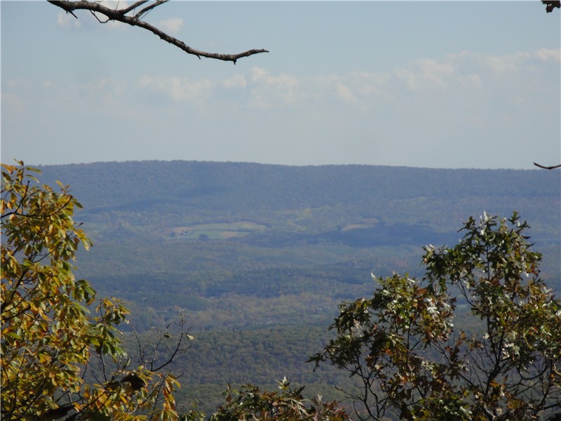
At 6.15 miles turn left on the blue-blazed Salamander Trail and pass some great views along the way.
Arrive at an intersection and turn left on the gravel road to Hawksbill summit.
After retracing your steps on the gravel road, turn left on the Lower Hawksbill Trail to return to the parking lot at Skyline Drive.  Cross over Skyline Drive and continue on the Cedar Run Trail which descends along more waterfalls.
At 10.85 miles turn right to return to the parking lot where the Cedar Run Link Trail goes to the left.  At 11.25 miles turn right as the Whiteoak Canyon Trail goes left.  Cross back over the bridge and arrive back at the parking lot at 11.40 miles.

HIKE SUMMARY:
[   0.00]  From parking lot start on blue-blazed trail; cross bridge; keep right at split
[   1.35]  Lower Whiteoak Falls
[   2.55]  Hiker warning sign not to exceed hiking ability
[   2.75]  At dirt road turn left, cross creek, continue on yellow-blazed Whiteoak Fire Road
[   4.35]  Stay left at fork where fire road becomes foot trail
[   5.00]  At intersection with Cedar Run Trail keep straight; cross Skyline Drive; take trail to right of parking lot
[   5.15]  At intersection turn left on the white-blazed Appalachian Trail
[   6.15]  Turn left on the blue-blazed Salamander Trail; white-blazed AT goes right
[   6.90]  Scenic view on Salamander Trail
[   6.95]  Second scenic view on Salamander Trail
[   7.00]  Turn left on gravel road to Hawksbill Overlook
[   7.20]  Leaving overlook backtrack to intersection; turn left on Lower Hawksbill Trail
[   8.10]  Arrive back at parking lot; cross Skyline Drive; continue on blue-blazed Cedar Run Trail
[   9.70]  Turn right to cross over creek at Upper Cedar Run Falls
[ 10.70]  Turn left to cross over creek at Lower Cedar Run Falls
[ 10.85]  Keep right on trail to parking lot as Cedar Run Link Trail goes left
[ 11.25]  Keep right when Whiteoak Canyon Trail goes left; cross bridge
[ 11.40]  Arrive back at parking lot

Cacapon State Park, WV


ABOUT THE PARK:  Cacapon Resort State Park - West Virginia State Parks

DIRECTIONS:

View Larger Map

I did this hike on my way from New Jersey to Virginia.  In addition to breaking up the drive with a hike, it enabled me to bypass a section of traffic-heavy I-81 on pleasant country highways.

After entering the park, follow the signs to the lodge registration office and park in the lodge parking lot.

TRAIL MAP:  Cacapon Resort Trail Map

HIKE DISTANCE:  6.50 miles

HIKE DIRECTIONS:
Walk back the way you drove in from the parking lot to the 4-way stop intersection.  Walk across the intersection towards the cabins.  At the end turn right, then turn left between cabins 21 and 22 to the green-blazed Laurel Trail.
Keep left on green at the intersection with the red trail where the reservoir can be seen to the right.  At .60 miles where the green Laurel, red Central and orange Ziler trails intersect, turn left on the red-blazed Central Trail.
Cross Middle Fork Road with cabins on the right.  At 1.65 miles the blue Ziler Loop Trail joins the red Central Trail for a short distance.  Stay straight on the blue Ziler Loop Trail when the red Central Trail veers to the right.
There may be a few limited, seasonal views along the way.

You will be ascending until you arrive at the ridge where you will find a bench at the intersection with the orange Ziler trail.
If you were to turn left on the orange Ziler trail for a few steps you will come to a woods road that runs along the ridge.  I hiked out a short distance to the left and found no views.  If you continue in that direction it would take you to the Cacapon Mountain Overlook, probably about 3 miles away.  This overlook can also be reached by car via a bumpy gravel road (more on that later).  For this hike, continue from the bench on the blue Ziler Loop Trail which will switchback down to a view around 4 miles.
At 4.80 miles the red Central trail joins the blue Ziler Loop trail briefly.  Cross a gravel road, turn left and walk a short distance turning right on the red Central Trail.  A short distance ahead keep right at an unmarked intersection.  Although there is no blaze at the intersection, you will see a red blaze a short distance ahead.  You might run into this friendly little guy.
As you near the reservoir at 5.60 miles, watch for the trail to make a sharp right turn which is easily missed.  If you find yourself walking along the reservoir, you missed the turn.
At 5.90 miles turn left on the green-blazed Laurel trail.  A white trail joins in after a short distance.  At 6.25 miles turn left at the intersection to go between cabins 21 and 22 from behind.  At the road turn right then left at the first intersection, through the 4-way stop and back to the parking lot.

If you would rather drive to the Cacapon Mountain Overlook (alternative is to add about 6 miles to the hike by taking the woods road at the bench intersection described above), drive as though you are exiting the park but turn right at the sign for the Cacapon Mountain Overlook.  (I believe this road is closed in the winter.)
Signs will warn of the condition of the road although I did not find it to be all that bad in an SUV.  Expect that your car will be covered in gravel dust.
Arrive at the Mountain Overlook at the top of the mountain.
You can also hike on the woods road along the ridge from this point.  I hiked out about half a mile and it was a fairly level hike out and back with some gradual ups and downs.