Sunday, August 22, 2010

Appalachian Trail, NJ - Millbrook Road to Crater Lake, Delaware Water Gap National Recreation Area


ABOUT THE PARK: Delaware Water Gap National Recreation Area

TRAIL MAP: NY/NJ Trail Conference Southern Kittatinny Trails Map #121

DIRECTIONS:
I-81 to exit 12 (Route 521-Blairstown); left on NJ-94 South to stop light; right on Bridge Street; right on High Street briefly on to Millbrook Road.

View Larger Map

GPS coordinates: 41.059215,-74.963497

There are a few parking options - I'll go into detail here since parking is limited.


Parking for two cars at the northbound A.T. trailhead where this hike starts:


Parking along Millbrook Road facing east - black car at southbound AT trailhead; red car at gravel pull-off. (These would be on your left heading west.)


HIKE DISTANCE: 12 miles out and back including loop around Crater Lake

HIKE DIRECTIONS:
Views are limited along this section of the AT. You catch glimpses of both east and west views between the trees so I would imagine views would be much better all along the ridge when the leaves are down. Much of this hike is fairly level with some ups and downs. You are starting out up high at 1250 feet with the highest elevation around 1490 feet.

Start northbound on the white-blazed Appalachian trail where it reenters the woods after following Millbrook Road west for a short distance.

At .4 miles arrive at Black's Pond which has a beaver lodge.


At .7 miles arrive at a power cut with views to the east and west, although marred by towers and power lines.


For the next 3 miles you will be walking along the ridge. The trail turns to smooth, easy woods road about half way along the ridge.


At 3.2 miles, a view over Fairview Lake to the east:


At 3.9 miles there will be a water pump to the left. Stay to the right, cross over Blue Mountain Lakes Road, turn right at the AT sign. Follow the road briefly and reenter the woods to the left at the next AT sign.


At 5.1 miles turn right on the orange-blazed trail which will bring you to the east side of Crater Lake. There are side trails to the lake, closer to the north end you will find picnic tables at the lake.


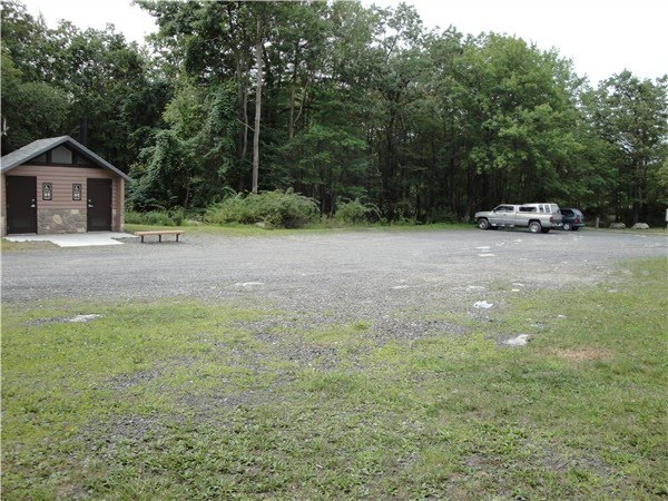
Because cars can drive up to the lake, there will be other people around. At the north end of the lake is a parking lot with surprisingly decent restrooms.


I could find no orange trail blazes at all in this area. To continue around Crater Lake, take the service road from the parking lot (across from the restrooms):


A short distance ahead the service road curves to the right, the orange-blazed trail goes to the left (blazes on tree). From this point the trail is again poorly blazed and several unmarked trails branch off. I did not do this correctly but did end up back on the A.T. which is what you want. I stayed left at the first fork, right at the second fork and that brought me to the white-blazed A.T. - turn left on the A.T. A short distance ahead is a view to the west.


From here stay on the white-blazed A.T. back to where the hike began.

NOTE: As you start to hike away from Crater Lake at the southern end, you will come to an intersection where the orange-blazed trail begins at triple blazes on the right. In this area, the orange trail loops around and crosses over the A.T. again a short distance ahead. If you continue straight ahead on the A.T. you will need to descend very steeply down an escarpment. If you prefer to avoid this section, take the less steep orange trail detour to the right, then right on the white-blazed A.T. when the trails intersect again.

Sunday, August 15, 2010

West Mountain/The Timp/Doodletown - Bear Mountain and Harriman State Parks, NY


ABOUT THE PARK:
NY/NJ Trail Conference Harriman-Bear Mountain State Parks
NY State Parks - Bear Mountain State Park
NY State Parks - Harriman State Park

TRAIL MAP:
NY/NJ Trail Conference Northern Harriman Bear Mountain Trails Map #119 (recommended)
New York State Parks - Bear Mountain State Park Trail Map

DIRECTIONS:
I-87/I-287 (New York State Thruway) to exit 13N (Palisades Interstate Parkway North); after 15 miles on Palisades Interstate Parkway North, exit 19 for US-6 East, keep right on Seven Lakes Drive; watch for narrow paved road on right (pictured below) in about .4 miles and turn right - no signs but this is the parking lot which holds about 12 cars.

GPS coordinates: 41.304258, -74.01571

HIKE DISTANCE: 7.3 miles (1st half moderate/strenuous, 2nd half easy)

HIKE DIRECTIONS:
NOTE: It seems that due to vandalism trail markers are often removed in these parks. I will note those areas and how to tell if you have gone too far.

Facing the barrier at the far end of the parking lot, take the white disk with red 1777W trail to the left.


Keep left on the 1777W trail at both of the forks (unmarked).

.25 miles - the 1777W trail turns right merging with the white-blazed Appalachian Trail for a short distance. When the trails split, stay right on the white-blazed A.T. leaving the 1777W trail.


.8 miles - after a steep uphill climb the white-blazed A.T. turns left; after another brief climb you arrive at east facing views of Bear Mountain with Perkins Tower and the Hudson River.


After another short uphill climb the blue-blazed Timp-Torne trail joins the white-blazed A.T. from the right, keep left on the blue/white trail to views facing west.


This trail continues along a ridge with several more west-facing views of Harriman State Park and the Palisades Parkway, which provides some traffic noise for a while until the trail leaves the ridge.


1.8 miles - At the trail junction sign, keep left on the blue-blazed Timp-Torne Trail when the white-blazed A.T. continues to the right.


A yellow trail will join for a while then branch off - continue on the blue-blazed trail.

2.3 miles - Arrive at the West Mountain shelter with great views of the Hudson and the New York City skyline.


Nice, shady break spot downhill a little bit beyond the shelter with great Hudson views and lots of overhead flight activity:


2.8 miles - after descending West Mountain, watch for the blue-blazed trail to make a left turn. An unmarked trail will go to the right. Although the turn is blazed on a tree, this turn is easy to miss if you are not paying close attention. If you end up at an intersection with the red-dot-on-white and red-cross-on-white trails, you missed the turn.

3.4 miles - arrive at The Timp summit with views of the Hudson River and the New York City skyline. You can also look back over at West Mountain and see the shelter you were at previously.


Stay on the blue-blazed trail as the red-dot-on-white trail crosses over.

4.4 miles - arrive at an unmarked intersection with a cairn in the middle. When you look to the left you will not see any markers on the trees. This is, however, where you turn left. You will not see markers for the 1777 trail until you walk farther down the trail.


If you come to this series of stone steps going up along a vertical rock wall, you missed the turn and need to backtrack.


The 1777 trail takes you through Doodletown, now an abandoned ghost town. Signs posted along the way point out interesting facts and sometimes show drawings or pictures of the homes which once stood at those sites.


There are also some old cemeteries. The oldest tombstone I saw was dated 1816 but there were many older stones which were illegible.


If you want to spend time more thoroughly exploring Doodletown, you might want to print out the map below from Wikipedia as we saw a note saying the sign you would come to as you entered Doodletown was removed by vandals.


6.0 miles (not counting walking around Doodletown) the 1777 trail splits off into the 1777W and 1777E trails at the sign:

Take the 1777W trail to the left.

6.5 miles - stay on the 1777W trail as the yellow-blazed trail crosses over.

7.0 miles - the white-blazed Appalachian Trail joins from the left briefly; keep left on the 1777W trail as it leaves the A.T. after a short distance.

Keep right at the two unmarked forks.

7.3 miles - arrive back at the parking lot.

Sunday, August 8, 2010

Copper Mines/Raccoon Ridge/Sunfish Pond, Delaware Water Gap NRA & Worthington State Forest, NJ


ABOUT THE PARK:
Delaware Water Gap National Recreation Area - NJ Hikes/Coppermines
New Jersey Department of Environmental Protection - Worthington State Forest

TRAIL MAP: NY/NJ Trail Conference Southern Kittatinny Trails Map #120

DIRECTIONS:
I-80 to New Jersey exit 1, north on Old Mine Road for 7.5 miles to Coppermines parking on left. GPS coordinates to parking area: 41.03738, -75.02915

HIKE DISTANCE:
Coppermines to Kaiser Road Loop: 6.2 miles
Coppermines to Raccoon Ridge and back to Kaiser Road: 8.2 miles
Coppermines to Raccoon Ridge to Sunfish Pond and back: 11.3 miles
Coppermines to Raccoon Ridge around Sunfish Pond and back: 12.5 miles

HIKE DIRECTIONS:
This hike description and mileage is for the 11.3 mile hike. The hike starts out at the red-blazed Coppermines trail which begins directly across Mine Road from the parking lot. Keep right at the fork that you come to early on. (The left trail goes to a lower mine from which you will need to backtrack.) The red-blazed Copper Mines trail involves a steep uphill climb but it's so pretty you don't realize just how much climbing you are doing. I have found it to be the best in April when the waterfalls are really flowing. The water was just a little trickle this time of year in August. Click here for April pictures of the Coppermines Trail.

The Coppermines Trail terminates at the white-blazed Appalachian Trail. Turn right and follow the white-blazed Appalachian Trail. You will soon see some views to the east.


At 3.9 miles you will pass the Kaiser Road trail on your right. Turn right here if you want the 6.2 mile hike, otherwise continue straight ahead following the white-blazed trail.


At about 4.5 miles you will leave the Delaware Water Gap National Recreation Area and enter Worthington State Forest. Soon thereafter there will be views of the Delaware River to the west.


Views to the east and west will open up more as you approach Raccoon Ridge indicated by a huge rock cairn in the center of the ridge.


North view of the Kittatinny Mountains:


For the 8.2 mile hike, turn around here following the Kaiser Road directions below, otherwise continue south along the white-blazed trail to Sunfish Pond.

Arrive at Sunfish Pond at 6.4 miles. Take the turquoise trail to the left for a short distance to a rocky area overlooking the pond.


On this particular day, this was as far as we could go due trail closures resulting from a forest fire at the south end of Sunfish Pond. Click here for fire report.


The Appalachian Trail along with the Turquoise trail and a woods road form a loop around the lake for the 12.5 mile hike.

Head back passing over Raccoon Ridge into the Delaware Water Gap Recreation Area at 8.5 miles to the junction of the Kaiser Road trail at 9 miles.


At 10 miles you have the option of taking a short spur trail back over to the red-blazed Copper Mines Trail where you would turn left to return to the parking lot.


Or continue on the blue-on-white blazed Kaiser Road trail to the second spur trail at 10.6 miles. Turn right on the spur trail and arrive back at the Coppermines trail at 11.1 miles, turn left and arrive at the parking lot at 11.3 miles.