

ABOUT THE PARK:
The Appalachian Trail in Virginia - Appalachian Trail Conservancy
DIRECTIONS:
This hike was done as a shuttle hike. I parked at Lot A (Appalachian Trail parking lot on Hwy 311) and hired a very nice gentleman from the Appalachian Trail Shuttle List to shuttle myself and my dog to Lot B (Andy Layne Trail parking) where we started the hike.
Lot A (Appalachian Trail parking lot on Hwy 311)
GPS Coordinates 37.380017,-80.089887
View Larger Map

Lot B (Andy Lane Trail Parking Lot)
GPS Coordinates 37.457589, -80.017241
View Larger Map

TRAIL MAP:
Trails Illustrated Map #788 Covington Alleghany Highlands - National Geographic
 |
| Picture of trail map in kiosk at AT parking on Rt. 311 |
PEAK BAGGING:
Tinker Mountain - Peakery.com
McAfee Knob - Peakery.com
Catawba Mountain - Peakery.com
APPALACHIAN TRAIL SECTION HIKING:
TrailHeadFinder.com - AT section miles 708.6 to 698.7
HIKE DISTANCE: 14 miles
THE HIKE:
 |
| Take the yellow-blazed Andy Layne Trail from the parking lot. |
 |
| Plaque on the rock at the beginning of the trail. |
 |
| A kiosk a little farther along the trail. There are 4 stiles on this trail (the wooden ladder over barbed wire fencing). The first stile by the kiosk can be walked around as there is no fencing in place. |
 |
| You will probably encounter cows. This little calf had been frolicking around and leaping in the air. It was too darned cute. In that moment I realized just how happy I am being vegetarian. |
 |
| First bridge crossing over Catawba Creek |
 |
| Lots of mud if it's been raining recently. |
 |
| Unique rock walls at Catawba Creek. |
 |
| Second bridge crossing over Catawba Creek. |
 |
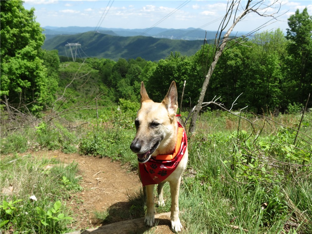
| If you have a dog along, the stiles will most likely present a challenge. My dog in particular, is scared to death of climbing them and I was concerned about this hike as I knew there were 4. Fortunately, I found a solution... |
 |
| I carry a small fleece blanket to sit on for breaks and it worked beautifully to cover the barbed wire so Shawnee could belly crawl under. |
 |
| The trail goes around the gate so it's OK to trespass if you are a hiker on the trail. |
 |
| The trail will start to ascend steeply... |
 |
| ... and switchback up... |
 |
| ... to the Appalachian Trail. The sign at this intersection says Hwy 311 is 9.1 miles but it's about 2 miles more than that. |
 |
| Coming up on Tinker Cliffs. |
 |
| Outstanding views from Tinker Cliffs. |
 |
| Waiting for someone to fall off the cliffs? |
 |
| The Appalachian Trail passes right along the edge of the cliffs but there is also a trail a few feet into the woods that provides an alternative for those of us who get shaky in the knees. |
 |
| The hike follows this entire ridge all the way over to McAfee Knob, the high point on the right. |
 |
| The hike along the ridge is mostly through woods but there will be another view to the east along the way. |
 |
| Nearing McAfee Knob, the AT touches briefly on a power cut with views before reentering the woods. |
 |
| Getting closer as the AT winds through rock formations. |
 |
| Just off the trail to the right is a nice rock outcrop but it's not McAfee Knob yet, although it's a lot less crowded. |
 |
| You'll be approaching this sign from behind so it's easy to miss. You'll need to turn right on a short side trail to get to... |
 |
| McAfee Knob! |
 |
| Our McAfee Knob photo was taken by AT thru-hikers "Sugarplum" from Georgia and "Mad Hat" from Minnesota. They had left Georgia in early March and had just completed 700 miles, 1/3 of the Appalachian Trail. |
 |
| From Mc Afee Knob, looking back along the ridge over to Tinker Mountain on the left. |
 |
| Continuing on towards our car that we left at the AT lot on Highway 311. |
 |
| A kiosk shortly before the parking lot. |

HIKE SUMMARY:
[ 0.00] Start on the yellow-blazed Andy Layne Trail at the rear of the parking; no fence by first stile
[ 0.55] Cross second stile (dogs can get under barbed wire) then cross bridge over Catawba Creek
[ 0.75] Cross third stile (large dogs cannot get under wire unless covered and lifted) then another bridge over Catawba Creek
[ 0.85] Cross forth fence style (dogs can get under wire on the left side
[ 1.20] Follow trail to left of gate with no trespass sign
[ 1.60] As trail turns right, Roanoke Cement Company to the left but hard to see with foliage
[ 3.15] Right on white-blazed Appalachian Trail at huge boulder
[ 3.85] Views of Catawba Valley begin at Tinker Cliffs
[ 5.70] Trail dips into a saddle where a woods road crosses over - keep straight uphill
[ 5.85] Partial view to left
[ 6.40] Nice break spot with views on top of rocks to left of trail
[ 6.65] Views of to the left
[ 8.85] Shelter on left
[ 9.00] Campsite with picnic table on left
[ 9.20] Trail comes out into power cut briefly for views before reentering woods to the right
[ 9.75] Small rock outcrop (not McAfee Knob yet) with view on right
[ 9.90] Turn right on rock surface side trail just before parking lot distance sign (McAfee Knob sign faces other way); retrace and continue south on AT
[10.70] Cross power cut
[11.30] Cross over fire road
[11.60] AT turns right where campsite is on left; shortly after side trail to left leads to shelter
[12.90] Shelter on left
[13.60] Kiosk on right, short side trail to left to views, continue straight on AT
[14.00] Cross Route 311 to parking lot


