Sunday, February 21, 2021

Edwin B. Forsythe National Wildlife Refuge, NJ - Cedar Bonnet Island


ABOUT THE PARK:  
Cedar Bonnet Island - Edwin B. Forsythe National Wildlife Refuge Facebook Page 
Cedar Bonnet Island Environmental Trail - South Jersey Trails  (How I found out about this hike - thanks South Jersey Trails!)

DIRECTIONS: 
GPS Coordinates 39.65718, -74.19371
Room for about 10 cars in a lot right off of Route 72 after crossing over Manahawkin Bay.
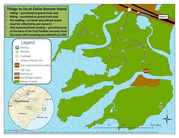
TRAIL MAP: 

HIKE DISTANCE: 
Cedar Bonnet Island - 1.5 miles
     hiked together with
Cloverdale Farm County Park - 2 miles
     12 miles/16 minutes away 

THE HIKE: 
As mentioned in the Cloverdale Farm hike, pardon the poor quality iPhone pictures.  Forgot to put the memory card in my good camera.
Head west from the parking lot a short distance along the sidewalk ...
... to the entrance on the left.
The path is all loose gravel which can be somewhat uncomfortable to walk on but where everyplace else is a sloppy, slushy mess and ice and snow, this was all bone dry.
We went left at the first fork and would be returning from the right.
Staying to the left here also for an out-and-back portion to a pavilion.
Heading back.
The bridge we had driven in on in the distance.
Now to the left to complete the loop portion.
Back at the entrance ...
... and a right turn back to the parking lot.

Cloverdale Farm County Park, NJ

ABOUT THE PARK: 
Cloverdale Farm County Park - Ocean County Parks 

DIRECTIONS: 
GPS Coordinates 39.75852, -74.27885
Small parking lot with room for about 10 cars.

TRAIL MAP: 
Cloverdale Farm County Park Map - Ocean County Parks

HIKE DISTANCE: 
Cloverdale Farm County Park - 2 miles
     hiked together with
     12 miles/16 minutes away

THE HIKE: 
Went to take the first picture and got the "no memory card" error message.  EGADS!  Forgot to put the memory card back in the camera.  I always keep a spare in my backpack for just such an occasion, however, I haven't been wearing my backpack on these short hikes.  So iPhone photos it is.
There is supposed to be an orange-blazed 1.4 mile trail and the only thing I saw from the parking lot that looked like it might be the trail was this post and a sign for the visitor center.  That was not it, but for lack of anything better, that is the way we went.
You  might not want to go this way from June to September.
We did run into trails and benches but no blazes.  No problem, we are always game to explore and nice that there were additional trails.
The trail loops around and comes at the reservoir.
Right on a dike between the cranberry bogs on the left and the reservoir on the right.  Turns out this is part of that orange trail but never saw any blazes.  Then again the bright sun was in my eyes so can't swear they weren't there.
Reservoir on the right ...
... cranberry bogs on the left.
After the gate the trail turns left along the cranberry bogs but I could hear voices that way so I took an unmarked trail up a bit on the right.
Higher up with no other people around.
Those people that were on the lower trail passed by as we came back to that trail along the bogs and looking to the left - there is the orange trail! 
And there are the blazes.
Since the people who were on that trail were now gone, we just backtracked on the orange trail along the bogs.
Taking another dike towards the visitor center.
Looping back around to where we found the orange trail.
We followed some bike tracks and footprints off trail but they didn't lead anywhere.
So backtracking on orange and staying with orange the rest of the hike.
Three out of focus deer with the lousy zoom on the iPhone.  Kicking myself again for forgetting the memory card.  Of course on this gorgeous day there were a ton of birds around but not even worth trying with the iPhone.
So there is the parking lot and here we are on the trail.  How did we miss getting on the trail?
The trail continues its loop past the parking lot.
To get to the lot it's a few steps over to the left.
Looking back, there are no signs at all and you would never know that is the trail.  To access it, you need to go between the shrubs where those people are coming off of the trail to the left of the parking lot drive.