

 |
| $15 per person entrance fee to receive a band for hiking the trails. |
DIRECTIONS:
GPS Coordinates 41.79550, -74.12767
 |
| Spring Farm Trailhead Parking |
TRAIL MAP:
Shawangunk Trails Map 105 - New York New Jersey Trail Conference
HIKE DISTANCE: 10.2 miles
THE HIKE:
The first cooler, low humidity day in weeks warranted taking a vacation day for a hike I would otherwise not do on weekends because of the popularity.
 |
| From the parking lot continuing up the gravel road a short distance to ... |
 |
| Million Dollar View |
 |
| Turning back there is a side trail to ... |
 |
| ... Table Rocks Trail. |
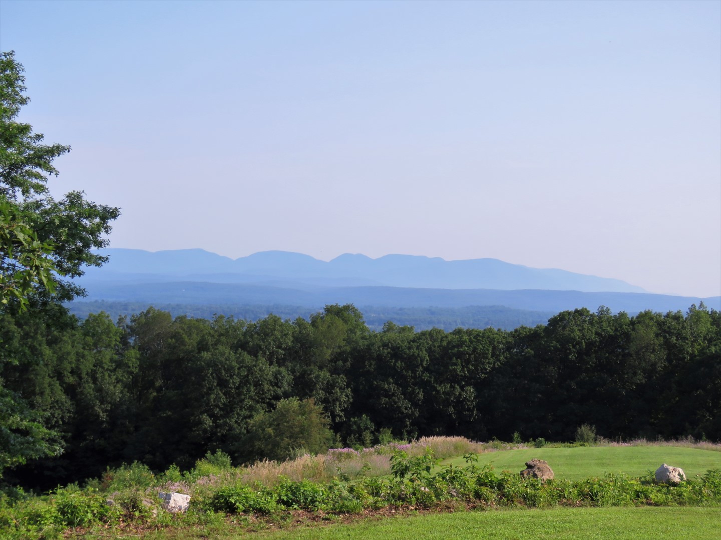 |
| More views of the Catskills from a little higher up. |


 |
| The Table Rocks Trail is blazed blue. |


 |
| At this intersection we turned left continuing on the Table Rocks Trail. Coming back we would be keeping straight which is to the right in this picture. |


 |
| The trail turns left off of the woods road. |


 |
| Table Rocks views. |

 |
| Retracing on blue. |

 |
| At that intersection with the map where Brodie wanted to continue retracing, we went straight on ... |
 |
| ... the red-blazed Clearwater Road Trail. |

 |
| Right on the blue-blazed Northeast Trail. |
 |
| This trail becomes considerably more rugged than the trails we had hiked so far. |

 |
| But it leads to view after view of the Catskills. |


 |
| On the yellow trail to Bonticou Crag which is the alternate trail to avoid a steep scramble. |
 |
| Hudson Valley views to the left. |


 |
| The red trail is the VERY steep scramble coming up from below. That was not going to happen with Brodie which is why I planned the yellow trail instead. |
 |
| Amazing views at Bonticou Crag |


 |
| Retracing on yellow then ... |
 |
| ... at the end of yellow ... |
 |
| ... left to continue on the Northeast Trail |


 |
| This leads to the bottom of the red trail. |
 |
| It would not have been possible to get Brodie up that scramble. |
 |
| Bonticou Crag from below. |
 |
| Continuing on the Northeast Trail, it is much more gentle and crosses a couple of small creeks. |

 |
| The Northeast Trail continues on for a bit but enters Mohonk Mountain House property where dogs are not allowed. We turned right on red. |
 |
| This is also the route of the Shawangunk Ridge Trail. |


 |
| From red we worked our way to the left to Bonticou Road. Several carriage road come together here so consulting the Gaia app helped navigate to the correct one. |
 |
| Smooth going now on carriage roads. |


 |
| Coming up on Mohonk Road ... |
 |
| ... where we crossed over. |


 |
| The path below to the right is Old Glen Anna Road where we would be heading next. |

 |
| A pretty brook along Old Glen Anna Road. |

 |
| Here we turned left on the red-blazed Rock Rift Trail. This turned out to be a big mistake. |
 |
| It starts out calm enough. Then ... |
 |
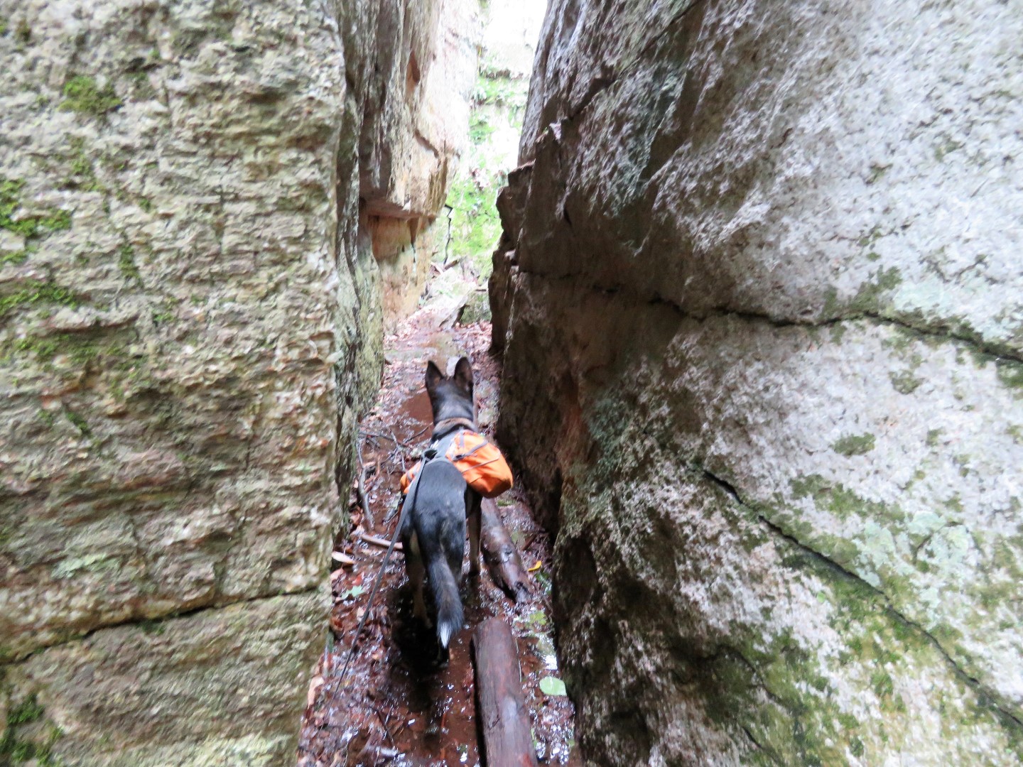
| ... SAY WHAT?!?!?!? |
 |
| Brodie whimpered pathetically and was afraid to come through. With some coaxing he finally did. I can't believe we actually fit through that tiny hole to get into there. |

 |
| Another one? |
 |
| This is more along the lines of what I was expecting it to be. |
 |
| But it just got more narrow and harder and steeper with larger boulders to navigate over. I had to stash the camera in my backpack and move it along ahead of me because no way was I fitting through with a backpack on. I can't even imagine how a grown man would fit through these rocks. I had a very hard time. Fortunately some kids with their moms came up behind me. The kids were slithering through like it was nothing. They had done this before and told me that before the end there was a "slide", a steep downhill smooth rock that was more narrow than anything we had been through so far and two ladders to climb up out of the crevice. Brodie would never make it. |
 |
| Fortunately, at that point, we could see the carriage road down below so we bailed and bushwhacked down a steep hill a short distance. |
 |
| We came out at the end of Old Glen Anna Road (just stay on that to avoid the red trail) then turned right on Cedar Drive. |
 |
| Just as we made that right turn on Cedar Drive there was a loud CRASH that startled us both. That tree had just fallen over. |
 |
| A bridge with a bench. Break time! |


 |
| Going back this way there is a bridge over Mohonk Road. |


 |
| Left on the red-blazed Northwest Trail. |


 |
| This starts to parallel Upper 27 Knolls Road that we had driven in on. |
 |
| Back at the Spring Farm Trailhead ... |
 |
| ... and through the parking lot. |
 |
| On the way home I passed an organic farm stand. I always set my GPS to "no tolls" for a more scenic drive home and in hopes of passing by these small farm stands. |
 |
| Not certified organic but they don't spray and that works for me. Nice prices, too. |
 |
| This beats produce from the grocery store any day. |