Friday, July 15, 2011

Catskill Forest Preserve, NY: Slide Mountain Wilderness - Peekamoose and Table Mountains


ABOUT THE PARK:
Slide Mountain Wilderness - NY State Department of Environmental Conservation
Peekamoose Mountain - Catskill 3500 Club
Table Mountain - Catskill 3500 Club

DIRECTIONS:
GPS Coordinates 41.915164, -74.429080

View Larger Map

There is parking for about 10-12 cars.  The lot fills up quickly.  People also use this lot for access to Roundout Creek across the street.

TRAIL MAP:
Southern Catskill Trails Map #143 - NY/NJ Trail Conference

HIKE DISTANCES:
Peekamoose Mountain - 7.3 miles
Peekamoose and Table Mountains - 9.2 miles
Buttermilk Falls - 0 miles (drive 1 mile east on Peekamoose Road)
Roundout Creek - 0 miles (across street from Peekamoose parking lot)

HIKE DESCRIPTION:
Although the parking lot is in Sundown Wild Forest, the trail soon enters Slide Mountain Wilderness.  The trail starts at the west end of the parking lot.

Slide Mountain Wilderness has a very generous pet policy:
If you Bring Your Pet-Your pet must be under your control at all times. When others approach, particularly small children and other animals, leash your dog. Keep your pet quiet. Remove droppings from the trail and camping areas.
Be sure to sign in at the trail register which you will find .15 mile into the hike.
The trail starts out as a woods road...
...then leaves the woods road as a foot trail.
The trail becomes rockier and you will need to rock scramble occasionally on the way up.
Reconnoiter Rock
A sign at 3500 ft. elevation.
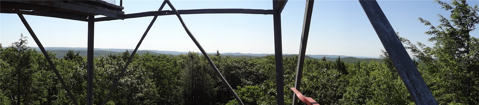
View to the East (click to enlarge then click again)
Trail through the spruce-fir forests of the higher elevations.
Boulder ahead is summit of Peekamoose Mountain - where my dog is standing is the unmarked side trail to a fairly recently cut view not shown on the Trail Conference map.
View of Ashokan Reservoir from Peekamoose Summit

View from Peekamoose Summit Overlook (click to enlarge then click again)
Rock cairn next to trail at summit of Table Mountain.
View to the west shortly after summit of Table Mountain.
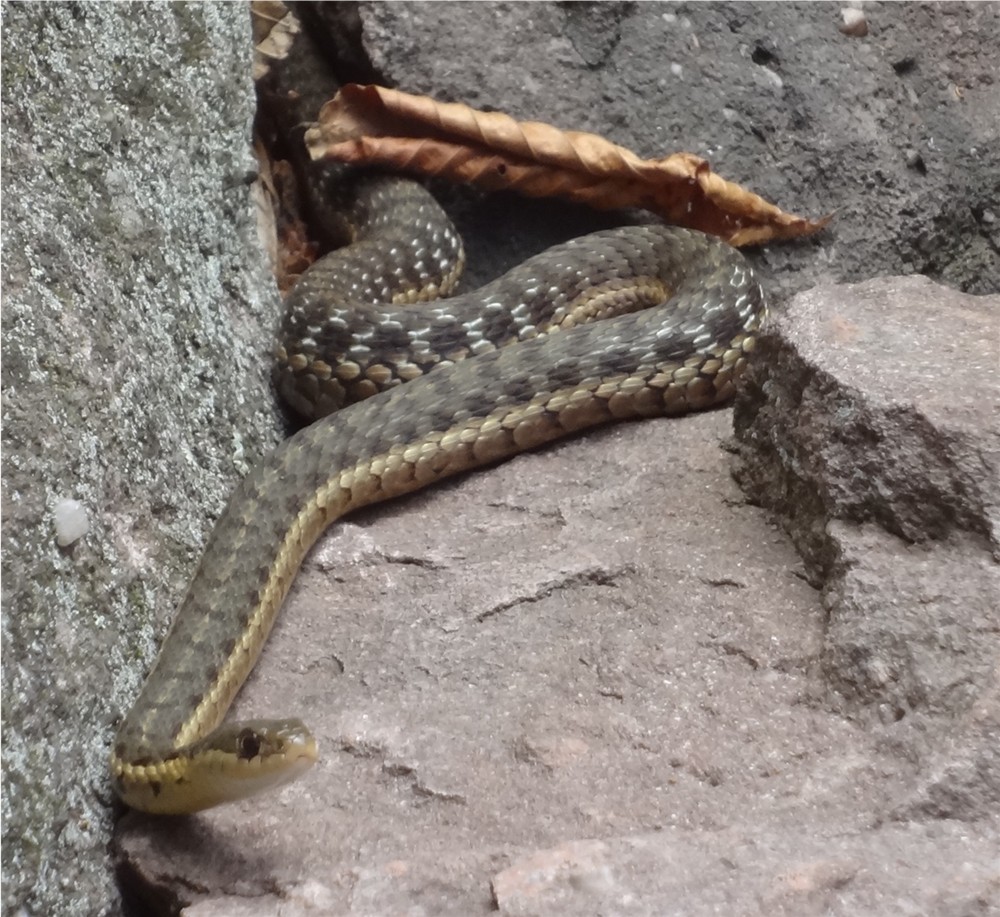
An Eastern Garter Snake in a crevice at Reconnoiter Rock on the way back.
Back at the parking lot after the hike, throw on some water shoes and head over to Roundout Creek to soak your tired legs in some ice cold water.  It gets much deeper than it looks in the picture.

Then swing by Buttermilk Falls, one mile east of the parking lot on Route 42.  There is a sign and a small parking lot.  A very short trail leads to the falls.  (You might want to stop here before doing the hike in case the parking lot fills up later in the day.)


HIKE SUMMARY:
[  0.00]  Start from west end of parking lot on blue-blazed Peekamoose-Table Trail
[  0.15]  Sign trail register on left
[  0.75]  Trail veer right as foot path leaving woods road
[  1.50]  Trail starts to switchback up more steeply; rock scrambles start
[  2.20]  Reconnoiter rock on left
[  2.80]  3500 ft. elevation sign; just beyond short side trail to right to eastern view
[  2.85]  View to the right
[  3.60]  Just before large summit boulder side trail to right to eastern view; retrace
[  3.65]  Large boulder at summit of Peekamoose Mountain
[  4.00]  Saddle between Peekamoose and Table Mountains
[  4.15]  Begin flat stretch along top of Table Mountain
[  4.45]  Rock cairn at Table Mountain Summit
[  4.50]  Take left fork to western view; retrace then right on blue trail to return
[  4.60]  Rock cairn at Table Mountain summit
[  5.20]  Saddle between Table and Peekamoose Mountains
[  5.35]  Large boulder at summit of Peekamoose Mountain
[  6.20]  Eastern view to the left
[  6.90]  Reconnoiter Rock
[  8.45]  Trail merges left back on to woods road
[  9.05]  Sign out at trail register
[  9.20]  Back at parking lot

Sunday, July 10, 2011

Sterling Forest State Park, NY - Sterling Ridge/Bare Rock Loop


ABOUT THE PARK:
Sterling Forest State Park - NY State Office of Parks, Recreation and Historic Preservation
Sterling Forest State Park - Hudson Valley Web TV

DIRECTIONS:
GPS Coordinates 41.187056, -74.308043

View Larger Map


TRAIL MAP:
Sterling Forest Trails Map 100 - NY/NJ Trail Conference
Sterling Forest State Park Trail Map - NY State Office of Parks, Recreation and Historic Preservation

HIKE DISTANCE:  10.6 miles

HIKE DESCRIPTION:
Start on the white/red line Lake-To-Lake trail.
This trail will dip into New Jersey before reaching the Sterling Ridge Trail.
Shortly after turning left on the combined white/blue dot Sterling Ridge Trail and teal diamond Highlands Trail scramble up rocks to a view.
View from Sterling Ridge Trail (click on picture to enlarge)
At just under 5 miles, arrive at the Sterling Fire Tower:
View from the 5th level of the fire tower - maybe someday I'll work up the nerve to make it all the way to the top.
View from Fire Tower
Sterling Lake from the Sterling Ridge Trail
Bare Rock Trail
Greenwood Lake from Bare Rock Vista
Greenwood Lake
Fire Tower Trail

HIKE SUMMARY:
[  0.00]  Start on white with red stripe Lake-To-Lake Trail at south end of parking lot
[  0.50]  White/red line trail turns left and joins woods road
[  0.80]  Continue beyond barrier on woods road
[  1.35]  Keep straight at cairn at intersection
[  1.65]  Cross bridge, veer right after crossing bridge to continue on trail
[  1.90]  NY-NJ Line marker
[  2.40]  At fork keep left then after short distance left again
[  2.45]  Left on White/blue dot Sterling Ridge Trail and teal diamond Highlands Trail
[  2.85]  View at top of rock scramble
[  4.10]  Turn right when unmarked goes left
[  4.25]  Keep straight when red trail joins in from the left
[  4.90]  Sterling Fire Tower
[  5.80]  Turn left on orange Bare Rock Trail at intersection
[  6.45]  Right on orange at fork when green goes left
[  7.15]  Right on Bare Rock Vista side trail
[  7.25]  Right on orange returning from Bare Rock Vista
[  8.90]  Turn right on red with white line Fire Tower Trail when orange trail ends
[10.20]  Unmarked side trail to right to view of Greenwood Lake (Bare Rock Vista has better view)
[10.45]  Cross bridge
[10.60]  Back at parking lot

Saturday, July 2, 2011

Delaware Water Gap National Recreation Area, NJ: Millbrook Village and Van Campens Glen


ABOUT THE PARK:
Millbrook Village - National Park Service
Van Campens Glen - National Park Service (link no longer works)
Tocks Island Dam Project - Wikipedia
DePue Burying Ground - Find A Grave

DIRECTIONS:
Millbrook Village Parking GPS Coordinates 41.073833, -74.963142

View Larger Map


TRAIL MAP:
Southern Kittatinny Trail Map 121 - NY/NJ Trail Conference

HIKE DISTANCE:  6 miles

HIKE DESCRIPTION:
This hike is usually done in a counter clockwise direction with Van Campens Glen at the end of the hike.  This is the clockwise version with Van Campens Glen at the beginning of the hike. Because Van Campens Glen is very popular, starting this way first thing in the morning avoids the crowds.
Pick up the gravel road through Millbrook Village to the left of the map in the parking lot.  Proceed through the village as the gravel road veer left and comes to a T-intersection.  Turn right briefly and cross over Millbrook Road to continue through the village.
Wagon Shop (restrooms around to the left of the building)
Millbrook School
Historic Dog House?
Be sure to print out the National Park Service brochure for explanations of all of the buildings.

Continue straight ahead at the end of the village and arrive at Watergate Picnic Area in another half mile.
Watergate Picnic Area
Just as you are entering the picnic area, look to the right under the trees for this grave marker:
According to NY-NJ-CT Botany Online:
Watergate was the 1950s estate of George Busch. There are only remains now, such as a stone dam with a Victorian turret and the grave of Busch's dog Bozo.
1952 – his wife Helene died at age 49.
1970 – George died in his sleep.
Source: www.buschfamily.net/Garrett/George/
Once through the Watergate Picnic Area, look for a trail to the left of an earthen dam which will soon cross Van Campens Brook on a small bridge.  When I did this hike this section was very overgrown.
Earthen dam - not the correct trail.  Take the trail down to the left on a lower level.
Where the trail up to now has been unmarked, you will soon start seeing the yellow blazes of the Van Campens Trail.
Van Campens Trail follows to the left of Van Campens Brook through hemlocks.
The Van Campens Trail ends at a parking lot/picnic area/restroom.  Turn right to Old Mine Road, turn left and walk along Old Mine Road a short distance then turn right on the Hamilton Ridge Trail which is an old woods road.  Watch a short distance ahead, near a low hanging power line, for a side trail to the right.  This trail leads to DePue Burying Grounds with tombstones from the 1800's.
Return to the Hamilton Ridge Trail and continue on as it becomes the orange-blazed Pioneer Trail.
Hiding in plain sight on the Pioneer Trail.
Old farms and homes now in ruins, abandoned because of the Tocks Island Dam Project that fortunately never happened.
At the top of the bluffs, the Delaware River is blocked by foliage.
The orange-blazed Pioneer Trail begins to ascend through a hemlock ravine:
Back on the Hamilton Ridge Trail, an abandoned paved road.
The Orchard Trail back to Millbrook Village


HIKE SUMMARY:
[  0.00]  Start on gravel road to left of parking lot map through Millbrook Village; cross Millbrook Road and continue through village
[  0.65]  Pass pond on right
[  0.70]  Trail veers right between to ponds then left towards Watergate Picnic Area; take left lower fork at opposite end of picnic area, cross bridge, cross power cut
[  1.25]  Keep straight across paved drive; brook is on right and yellow blazes start
[  1.60]  Left on paved path
[  1.65]  Turn right at hiker's sign leaving paved path
[  1.95]  Descend steps
[  2.05]  Cross bridge
[  2.15]  Ascend steps
[  2.50]  Turn right at parking lot/picnic area/restroom
[  2.55]  Turn left and walk along Mine Road
[  2.60]  Turn right on Hamilton Trail, woods road beyond barrier
[  2.65]  Turn right on unmarked path to DePue cemetary
[  2.70]  DePue cemetary; retrace back to Hamilton Trail
[  2.75]  Continue left on Hamilton Trail
[  2.90]  Keep straight on orange-blazed Pioneer Trail
[  3.50]  Stay right on orange trail as woods road veers left
[  4.80]  Orange Pioneer Trail ends, left on paved Hamilton Ridge Road (unmarked)
[  5.40]  Turn right on orange-blazed Orchard Trail
[  6.00]  Cross Old Mine Road back to Millbrook Village parking lot