ABOUT THE PARK:
The Trout Brook Valley Conservation Area, managed by the
Aspetuck Land Trust, consists of interconnecting Crow Hill Nature Preserve, Trout Brook Valley Preserve and Jump Hill Preserve totaling 1,009 acres with 20 miles of exceptionally well-marked hiking trails. Dogs are allowed off leash (please do not abuse this rare privilege) - details of regulations on the map/brochure link, below.
(NOTE: As of September 2011 dogs are no longer allowed off leash. This was my fear when I observed dogs running amok off trail, aggressive dogs that were not leashed... Click here for updated policy.)
DIRECTIONS:
There are multiple parking areas. These directions are to the Elm Drive cul-de-sac parking area. Other parking options nearby are shown on the trail map.
GPS Coordinates: 41.24604,-73.334091
View Larger Map
TRAIL MAP:
The numbers on the map correspond with numbers posted on trees along the way.
HIKE DISTANCE:
My hike was 11 miles but the trails are so interconnected hikes can be as short or as long as you want them to be.
HIKE DESCRIPTION:
Starting from the Elm Drive parking area take the short orange trail then turn left on the blue and blue/white trail. Stay right on the blue trail as it leaves the blue/white trail. After crossing over the white trail, the blue trail joins with the green trail. From this point follow the green trail as the blue trail leaves to the right and the white trail joins in. Along this stretch, a short unmarked side trail to the left arrives at a plaque.
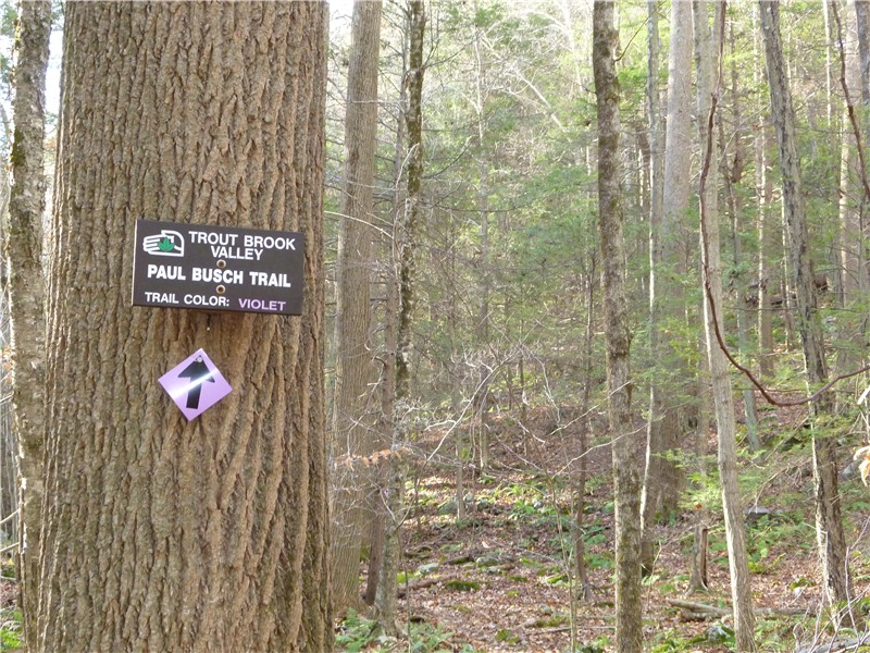
Shortly after the white trail leaves to the left, cross a brook and turn left on the violet trail through pretty hemlock forests.
At marker 33, turn right on the red trail.

The red trail will climb steeply - ropes have been installed to assist with the climb up.

At marker 29, turn left on the purple trail which arrives at a view (probably seasonal) of Saugatuck Reservoir in .4 miles.
Backtrack on the purple trail and turn left on the red trail. The red trail briefly becomes the green trail between markers 17 and 19. Continue on the red trail all the way up to Jump Hill Preserve.


When the red trail ends at marker 53, continue left on the white trail.


At marker 47 turn right on the black/red trail, passing a golf course on the left, continuing all the way to the end at marker 16.
At marker 16 turn left on the white trail briefly, then left on the yellow trail.
From the yellow trail the ridge of the red trail from earlier in the hike is visible through the trees.

At marker 36 turn left on the gray/white trail which will loop around and descend steeply to the red/white trail.
At marker 10 turn left on the orange trail crossing a bridge over a brook.

Stay on the orange trail as the blue trail joins in. Turn left on the magenta orchard trail at marker 28. Turn right at the sign below.
After crossing the boardwalk, walk parallel to the orchard fence for a short distance then enter through the gate.

Straight through the field after entering the gate is a sign asking visitors not to pick the produce.
There are nice views of the orchards and surrounding countryside from this high spot on the hill.

Head south through the orchard towards the blueberry patch. Along the way watch for a second gate on the right which will be the exit later.

Return to the gate to exit the orchard following the magenta trail to the end. Keep left on the yellow/white trail into Crow Hill Preserve. Cross over the gravel path, accessible from the end of Norton Road, which is where you will find most of the walkers.
At the end of the yellow/white trail continue on the blue/white trail where you might find a delightful surprise in the middle of the woods.
At marker 40 turn left briefly then right on the short trail back to the Elm Drive parking area.
HIKE SUMMARY:
My pedometer battery died so these mileages are VERY approximate based on map estimations.
[ 0.00] Take trail from parking area to left on blue and blue/white trail
[ 0.20] Right on blue trail
[ 0.40] Cross white trail, join with green trail
[ 0.75] Stay on green trail we blue trail leaves
[ 1.00] Left on violet trail
[ 1.60] Right on red trail
[ 2.00] Left on purple trail
[ 2.40] View of Saugatuch Reservoir; backtrack to red trail
[ 2.80] Left on red trail
[ 5.10] Left on white trail
[ 5.40] Right on red/black trail
[ 6.40] Left on white trail; left on yellow trail
[ 7.20] Left on gray/white trail
[ 7.50] Right on red/white trail; left on orange trail
[ 8.10] Left on magenta trail to orchard (mileage includes walking to southern part of orchard)
[ 9.20] Left on yellow/white trail
[10.00] Right on blue/white trail
[11.00] Return to Elm Drive parking area.


 Along the way you might notice old blazes which have been painted over. The painted over right turn blaze at the end of the woods road at 5.4 miles brings you back to the intersection with the red square on white Popolopen Gorge trail to continue on straight ahead.


 A short distance ahead at the 7 mile point, turn right on the 1779 Trail.