ABOUT THE PARK:
Worthington State Forest - NJ Department of Environmental Protection
Garvey Springs Trail - National Park Service
Douglas Trail - National Park Service
Rock Cores Trail - National Park Service
Appalachian National Scenic Trail - National Park Service
DIRECTIONS:
GPS Coordinates 41.00513, -75.09799
 |
| Pull-out parking just north of the Worthington State Park campground entrance. |
 |
| The Rock Cores Trail starts across the street from the pull-out and there is a larger pull-out with room for more cars a little farther north, just to the left up ahead in this picture. |
TRAIL MAP:
Southern Kittatinny Trails Map #120 - NYNJ Trail Conference
Worthington State Forest Trail Map - NJ Department of Environmental Protection
Worthington State Forest Map - NYNJ Trail Conference free maps
HIKE DISTANCE: 8.25 miles
THE HIKE:
Shawnee sat this one out so I was able to do a more challenging hike. She had some difficulty on last week's hike and can't handle the heat and humidity. Plus the weather was unpredictable with scattered rain and thunder storms.
 |
| Heading up on the Rock Cores Trail. |
 |
| Wood Thrush |
 |
| At the intersection, the Douglas Trail comes in from the right. I would be coming out the way later but for now, left on the combined Rock Cores Trail/Douglas Trail. |
 |
| After that intersection, the trail becomes a footpath where it was a woods road up to that point. |
 |
| At the next intersection just a short distance ahead, the Douglas Trail leaves to the left, the Rock Cores Trail to the right over that huge rotten log. I stayed right on the Rock Cores Trail. |
 |
| Numbered posts appear but I have not been able to find a guide that explains what they mean. |
 |
| Crossing over runoff from Sunfish Pond on it's way down to the Delaware River. |
 |
| The orange Garvey Springs Trail joins in from the right. |
 |
| Where the Rock Cores Trail veered left, I stayed right on the Garvey Springs Trail. |
 |
| It becomes steeper, more narrow and rockier. |
 |
| Worm-eating Warbler |
 |
| Scarlet Tanager |
 |
| At the top, right on the Appalachian Trail. |
 |
| I took the blue side trail on the left to the Sunfish Pond overlook first. |
 |
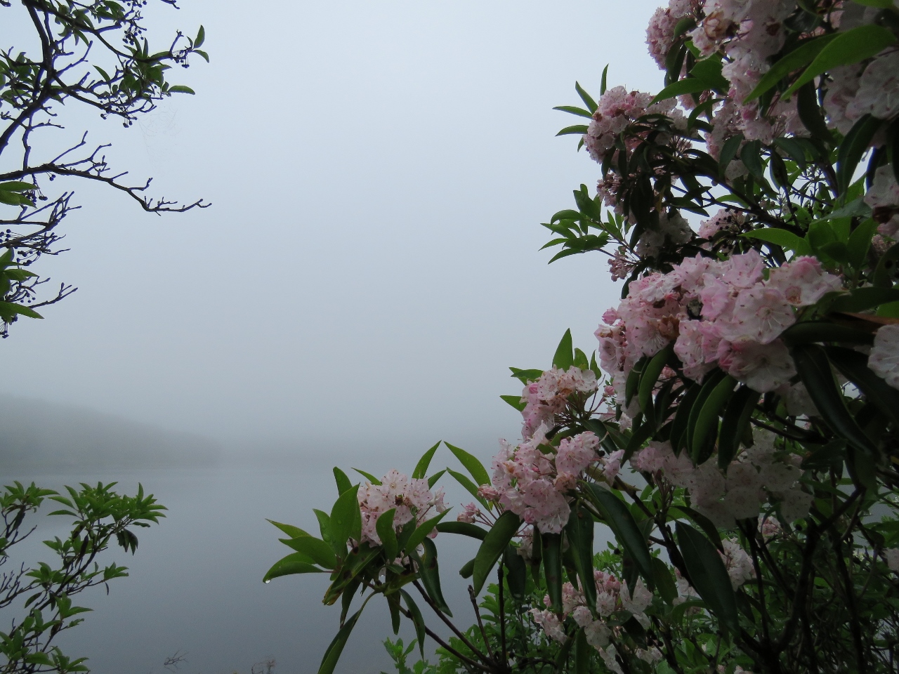
| Beautiful mountain laurel on this trail. |
 |
| But no Sunfish Pond view with all of the fog. |
 |
| Back on the Appalachian Trail. |
 |
| It becomes very rocky as it passes along Sunfish Pond. |
 |
| Rock art in front of what would be Sunfish Pond without the fog. |
 |
| The top of the runoff from Sunfish Pond. |
 |
| Eastern Towhee |
 |
| At long last, just as I reached the far end of Sunfish Pond, the fog lifted enough to actually see it. |
 |
| I hope that is not a dragonfly that the gray catbird has. We need those for mosquito control. Go eat mosquitoes! |
 |
| And just as Sunfish Pond was clearing, it started to pour. When I saw the first drops I hurried up and put on rain gear, just in time for the downpour. |
 |
| A quick shot back at the Sunfish Pond signs before zipping the camera back up in my rain jacket. |
 |
| From this point on, the Appalachian Trail is mostly smooth woods road all the way to ... |
 |
| ... the huge backpacker campsite at the intersection with the Douglas Trail. |
 |
| I turned right on the Douglas Trail which goes downhill on a woods road. It is a smoother descent than the climb up was on the Garvey Springs Trail so I was glad I had done the hike in this direction. |
 |
| Looking over the campground to what might be views if it were clear enough to see. |
 |
| A red-headed woodpecker which is listed as near threatened, a species I have not seen in several years. He allowed me this one shot, then he was gone. |
 |
| This frog, however, posed for several shots. |
 |
| The rain was intermittent - as soon as I would remove rain gear I would have to stop and put it back on again. And again. And again. |
 |
| Scarlet Tanager - seeing a lot of these guys this year where I had rarely seen them before. |
 |
| Wood Thrush |
 |
| At the intersection with the Rock Cores Trail where I passed the Douglas Trail earlier in the hike, it would be a short distance back to the car to go left but I went right, retracing part of the earlier hike, because I was not finished yet. |
 |
| At that intersection where the Rock Cores Trail leaves right over the rotten log, I now stayed left on the Douglas Trail. |
 |
| At the end of the Douglas Trail an unmarked trail goes right just past the sign ... |
 |
| ... up to Laurel Falls. This is just the first section. Continue up a bit... |
 |
| ... to the second part of the falls. This is where all that runoff from Sunfish Pond comes tumbling down at the bottom. |
 |
| Heading back down along the falls. |
 |
| A plaque at the bottom at the Douglas Trail. |
 |
| Crossing over Old Mine Road to... |
 |
| ... the Douglas Trail parking lot, another parking option. I had not parked here because I wanted an early out option in case it started storming too badly so where I did park gave me that option. |
 |
| Continuing on through ... |
 |
| ... where I found a trail not on the map to the right heading towards the Hemlock Grove Picnic Area. |
 |
| There are Delaware River views along this trail |
 |
| Hemlock Grove Picnic Area - continue through the picnic area to ... |
 |
| ... the trail that goes on along the Delaware River all the way to ... |
 |
| ... Old Mine Road. |
 |
| Heading back. |
 |
| Coming off of that trail back to the campground. |
 |
| My intention was to walk back on the campground road instead of on Mine Road. The sign on the left says "registered campers only beyond this point." Wasn't quite sure if that meant I was not allowed to walk through but I decided to give it a try. There were so many people camping, I doubt anyone noticed or cared. It's not like I was trying to set up camp without registering. Just passing through.... |
 |
| At first it's just a paved road through the campground ... |
 |
| ... then it becomes more scenic with river views. |
 |
| Great Blue Heron |
 |
| At the park office, just follow the exit sign ... |
 |
| ... to the exit ... |
 |
| ... and a left turn back to the parking pull-out. |


You got some gorgeous photos! I like the way the fog looked in your photos. Looks like a great place to hike but strenuous. Sorry Shawnee couldn't make it but you made the right decision leaving her behind especially with the humidity. Thanks for sharing! Joanne from NJ
ReplyDeleteThe fog really adds a mystical quality to these photos!
ReplyDeleteNice to see those rock cairn arts still standing. These days it wouldn't be unexpected for some thoughtless moron to trash them. :( Hope you didn't get too drenched. Yet through all that rain and fog you still managed to get some absolutely super pics of birds! I think they know when you're coming & just wait. :)
ReplyDeleteLinda
Beautiful post! Thank you! Is there a configuration of trails that would include the falls but only be about 5-6 miles?
ReplyDeleteThanks
Thanks! This time of year you probably won't find many falls as they are usually dried up after the summer drought. Spring is the best time and this hike has amazing falls in the spring. It can be made shorter, you'll need to refer to a map. http://gonehikin.blogspot.com/2010/04/delaware-water-gap-copper-mines-at.html
Delete