Sunday, June 3, 2012

Wawayanda State Park, NJ - Terrace Pond North and South


ABOUT THE PARK:
Wawayanda State Park - New Jersey Department of Environmental Protection

DIRECTIONS:
GPS Coordinates 41.157558, -74.367454

View Larger Map
Paved parking for several cars along westbound side of Warwick Turnpike.

TRAIL MAP:
Wawayanda State Park Trail Map - New Jersey Department of Environmental Potection
North Jersey Trails Map #116 - New York New Jersey Trail Conference

PEAK BAGGING:
Bearfort Mountain - NJ1K.org
Bearfort Mountain - Peakery.com

HIKE DISTANCE:  10.65 milles
Terrace Pond North only (most scenic) - 5.4 miles - NJ Hiking or Dan and Laura's Photo Album
Terrace Pond South only 4.8 miles - NJ Hiking (starts from parking on Clinton Road)

THE HIKE:
Walk back east on Warwick Turnpick to the beginning of the parking pullout and the trail starts across the street.
Views start about half a mile into the hike.
A little higher Greenwood Lake comes into view.
Mountain Laurel still in bloom.
Pretty cascades and pools.
New York City Skyline
View from the pipeline.

A tricky crossing at a "seasonally wet spot".  In case you are wondering what might happen if you fall in....
... this would be the result.
Terrace Pond looking south.
Back at the pipeline for a short distance.
Pipeline beautification in progress?
End of the blue trail at Clinton Road parking.
Blue trail ends and yellow trail starts at the bench.
Some lost dogs in the area if you happen to see them.
Bear print in the mud on the yellow trail.
Black rat snake.
Easy hiking on woods road after lots of rugged terrain.
The trail skirts a swamp on the left.
Cute garter snake.
A final look at the swamp before the camera had to be sealed up and put away due to rain, lightning and thunder.
A break in the rain back at Terrace Pond (from the east looking west)
Clouds breaking up over the pipeline.
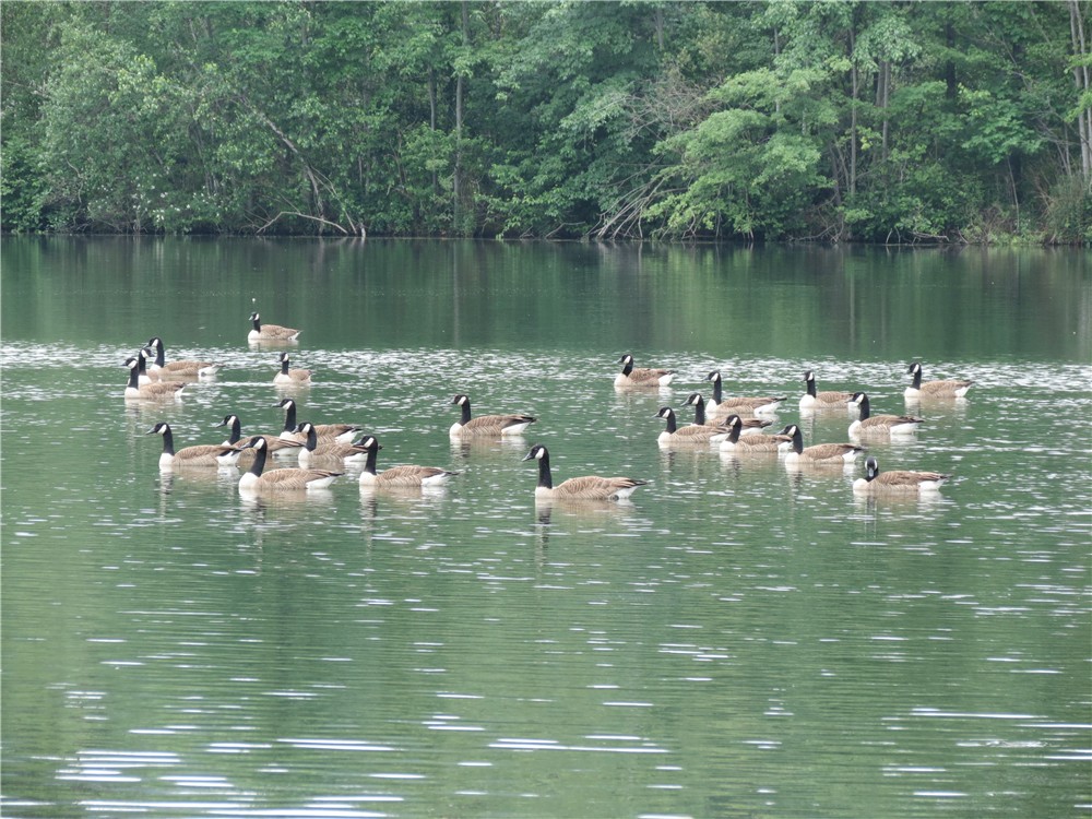
Downpour over Greenwood Lake on the left, not raining on the right.
Double rainbows over Greenwood Lake.
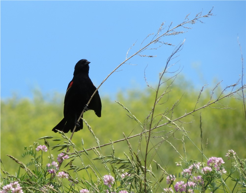
A hawk flying by the rainbow.


HIKE SUMMARY:
[  0.00]  Walk east on Warwick Pike to end of parking pullout, cross over to trail head
[  0.60]  Views begin
[  1.00]  Pools and cascades on the left, rock hop a couple of creeks
[  1.45]  New York City skyline comes into view
[  1.80]  Turn right at pipeline
[  1.90]  Turn left to other side of pipeline but stay in pipeline
[  2.05]  Leave pipeline to the left at large cairn
[  2.60]  Stay right on blue when white joins in from left; descend down vertical rock wall
[  2.65]  Cross swamp carefully on logs
[  2.70]  Short side trail on left to view of Terrace Pond; another steep vertical descent but it can be bypassed to the left; keep right on blue when white leaves to the left
[  2.85]  View west at top of huge boulder
[  3.30]  Turn left in pipeline and keep straight when passing two unmarked trails on left
[  3.40]  Leave pipeline to left on woods road
[  3.50]  Rock hop creek
[  3.70]  At fork turn right and cross creek on large rocks (easy to miss, blazes falling off tree)
[  4.00]  Blue ends at Clinton Road, make sharp left on yellow at bench
[  4.15]  Cross swamp on puncheons then large rocks, cross more wet area on rocks
[  4.45]  From this point wet areas no longer have rocks placed for crossing, pick your way across the best you can
[  5.00]  Pass through old stone wall, woods road comes in from right
[  5.10]  Yellow turns left as another woods road comes in from right
[  5.50]  Yellow makes sharp left turn at well-blazed intersection
[  5.60]  Swamp comes into view on left, trail skirts swamp
[  5.75]  Keep left on yellow when unmarked goes right
[  6.00]  Step over large concrete drainage pipe; watch for yellow trail to go right around swampy area and continue on the other side
[  6.10]  Keep left on yellow when yellow dot goes right
[  6.80]  Keep left on yellow when red joins in from right, after a few steps turn left on red when yellow goes right (I had intended to stay on yellow here but it was so overgrown and swampy it was impassible)
[  7.15]  Red ends, turn right on white (you can turn left on white also but you would have to cross that swamp again and go up the steep vertical wall from earlier in the hike - getting my dog up that wall was not an option)
[  7.35]  Left on white when yellow goes right (this is where yellow comes out had it been passable)
[  7.50]  Straight on white when yellow dot comes in from right
[  7.90]  Turn right on blue when white turns left joining blue (retracing first part of hike from this point)
[  8.45]  Turn right at pipeline
[  8.70]  Leave pipeline to the left
[  9.60]  Cascades and pools
[10.65]  Cross Warwick Pike back to parking

Saturday, June 2, 2012

Hawk Rise Sanctuary, NJ


ABOUT THE PARK:
Hawk Rise Sanctuary - New York New Jersey Trail Conference
Hawk Rise Sanctuary to Open in Linden - Suburban News
Hawk Rise Sanctuary - New Jersey Audubon

DIRECTIONS:
GPS Coordinates 40.603003, -74.251767

View Larger Map
Parking on the left just before the animal control facility and animal shelter at the end of Range Road.

TRAIL MAP:
Yellow is the existing trail (unblazed).

HIKE DISTANCE:  1.25 miles
This is not actually a hike but I felt it was worth mentioning since this is a new trail in an area where there are very few trails.  It is almost across the street from Merck Pharmaceuticals in Rahway - a great lunch hour place for employees - or a quick leg stretcher if you happen to be in the area.  Lots and lots of birds here!

THE HIKE:
From the kiosk the trail starts as a gravel path which leads to a boardwalk.
Boardwalk through wetlands with viewing area and interpretive signs.
First bird sighting from the viewing area - a female red-winged blackbird (Thanks, Dan Balogh for the ID!).
There is a stark difference between the boardwalk meandering through the woods and the unattractive industrial area just out of view.
The trail alternates between boardwalk and gravel paths.
Approaching the landfill where birds abound.
Observation deck adjacent to landfill overlooking wetlands.
Path between wetlands and landfill.
At the kiosk it states no pets are allowed yet there is a poop bag dispenser? 

HIKE SUMMARY:
[  0.00]  From the kiosk veer left on the gravel path towards the boardwalk
[  0.15]  Keep left at end of boardwalk
[  0.40]  At the end of the boardwalk, veer right on gravel path when dirt road goes left
[  0.50]  Keep left at fork to interpretive sign; retrace
[  0.55]  Left on gravel road coming off trail to interpretive sign
[  0.65]  Turn left on boardwalk towards landfill
[  0.70]  At end of boardwalk turn right along split rail fence (no sign but left on dirt road is not allowed)
[  0.80]  Observation deck at end; circle around and retrace
[  0.95]  At end of split rail fence, turn left on boardwalk when off limits dirt road goes straight
[  1.00]  At T-intersection turn left on boardwalk
[  1.10]  At intersection turn left on boardwalk
[  1.15]  At intersection turn left on gravel path when right goes to parking lot
[  1.25]  Back at parking lot

Wednesday, May 30, 2012

Franklin Lakes Nature Preserve, NJ


ABOUT THE PARK:
Franklin Lakes Nature Preserve - Borough of Franklin Lakes

DIRECTIONS:
GPS Coordinates 40.975767, -74.195462

View Larger Map

TRAIL MAP:
Franklin Lakes Nature Preserve - New York New Jersey Trail Conference
Note:  The blue-blazed trail does not span across the lake as shown on the map.  It currently consists of two separate sections that do not connect.

HIKE DISTANCE:  2.3 miles

THE HIKE:
Facing the lake there is a kiosk on the right...
Turn left and cross the dam to start the hike on the white-blazed trail.
White-blazed trail around the lake.
A Red-winged Blackbird seen from the dam.
Part of the trail runs along a chain link fence between the lake and the road...
... but focusing on what is in the water drowns out the traffic noise.
Franklin Lake from the High Mountain Road side.
Irises along the lake.
Leave the trail briefly through an opening in the fence to cross on the road bridge, then reenter at the next fence opening.
After reentering through the fence opening, turn right on the blue-blazed trail for a short out-and-back.
High Mountain on the other side of the lake from the blue-blazed trail.
Back on the white-blazed trail, a rock hop over a creek.
When Dan Balogh did this hike on April 15, 2012, there were Canada goose nests with eggs.  I saw no goslings at all.  It is supposed to take 56 days for goslings to attain full plumage but it has only been 38 days since they were eggs - could they be this big already?
Another section of blue-blazed trail.
High Mountain from the blue-blazed trail.
Pine trees near the end of the white-blazed trail.
Picnic tables in a pretty pine area along the lake.
Watched the swan family from the picnic table.
After the children were tucked away with one parent, the other came back out and put on quite a show.


HIKE SUMMARY:
[  0.00]  Facing lake turn left and cross dam on white-blazed trail
[  0.75]  Leave trail to left through break in fence to cross bridge
[  0.80]  Reenter trail to right through fence opening on the other side of the bridge; turn right on blue-blazed trail
[  0.95]  End of blue-blazed trail; retrace
[  1.15]  Turn right on white at end of blue trail
[  1.25]  Rock hop over creek
[  1.55]  Turn right on blue-blazed trail
[  1.75]  End of blue-blazed trail; retrace
[  1.95]  Turn right on white when blue-blazed trail ends
[  2.30]  Picnic tables; back at parking lot