Monday, April 4, 2011

Kelly's Run - Pinnacle - Tucquan Glen Nature Preserve on the Conestoga Trail, Lancaster County, PA


ABOUT THE PARK:
PLEASE NOTE:  PPL no longer owns Holtwood Recreation area and as of 4/28/2016 Holtwood Recreation area is closed to the public per this article


Holtwood Preserve - Kelly's Run Pinnacle Area - (dead link, no longer owned by Pennsylvania Power and Light)
Tucquan Glen Nature Preserve - Lancaster Conservancy
     the above two areas connected by
Conestoga Trail System - Lancaster Hiking Club

DIRECTIONS:
THIS PARKING AREA IS CLOSED AS OF 4/28/2016 PER THIS ARTICLE
GPS coordinates to Holtwood Recreation Area parking: 39.840816, -76.316856

View Larger Map
Holtwood Recreation Area Parking

TRAIL MAPS:
Tucquan Glen - Conestoga Trail Rerout - Lancaster Hiking Club
Topo Map of Area - USGS (search for "Holtwood, PA", left click on red balloon, download 1990 map)

HIKE DISTANCE:  8.75 miles

HIKE DESCRIPTION:
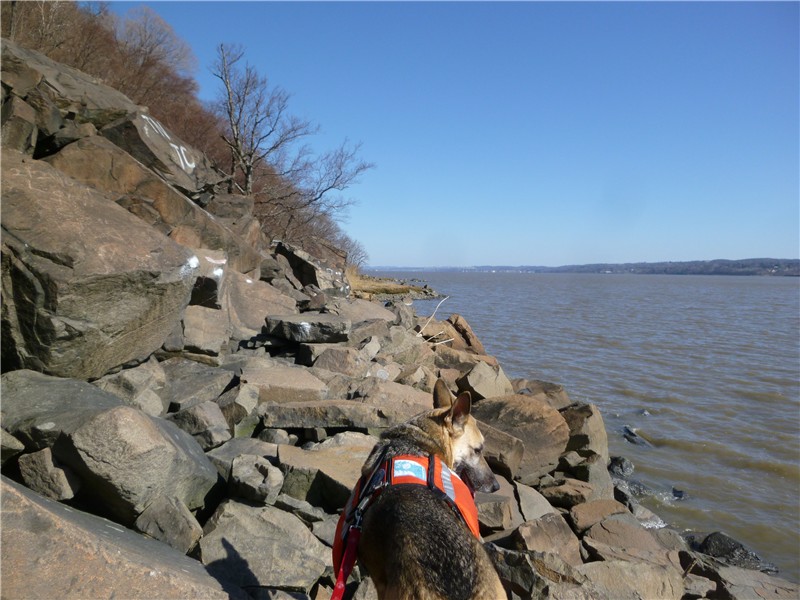
This very rugged and strenuous hike with lots of rock scrambles, rock hops, steep uphills and downhills will reward you with incredible scenery and views. Trails are very well-blazed.

In the parking lot with your back to the road, head to the right corner of the parking lot where you will see orange blazes leading towards a small building (seasonal restrooms - still closed 4/3) across the way.
The trail turns right in front of the restroom building then left into the woods at a post which says "CONESTOGA TRAIL" on one side and "KELLY'S RUN TRAIL" on another side.
You will be following the combined orange (Conestoga Trail) and blue (Kelly's Run Trail) which will soon come to Kelly's Run.  Pay close attention to the terrain for the next 1.35 miles up to where a white-blazed trail goes to the right.  You will want to be able to determine if you want to take this as the return route or a less rugged but somewhat longer alternate route on your way back.  The most rugged part of the Kelly's Run Trail is beyond the intersection with the white trail but that won't be part of the return route.  Expect multiple rock hops over Kelly's Run.  With waterproof hiking shoes you should be able to do them all without getting wet. (Note - there will be a crossing later in the hike at Tucquan Glen where you should anticipate getting wet.)


At the end of Kelly's Run, watch for the orange Conestoga Trail to turn right up stone steps where the blue Kelly's Run Trail heads straight towards the railroad tracks and the Susquehanna River.
At the top of a rock scramble, the Susquehanna River comes into view:
A smoother, gentler orange/yellow trail along the top leads to the Pinnacle Overlook:

The orange-blazed Conestoga Trail continues beyond the Pinnacle to a quieter rock outcrop a short distance ahead.
The Conestoga Trail continues through rugged terrain with early wildflowers blooming and crosses several small creeks:
The trail descends to the railroad tracks where it makes a sharp right turn just before Tucquan Run and continues with orange and blue-blazes having joined with the Tucquan Glen Nature Preserve's blue-blazed trail.


Shortly after crossing the wooden bridge, you will have to ford the creek to continue on the orange-blazed trail to the other side.  Most of the rocks are under water far enough to fill even waterproof hiking shoes up.  I had anticipated this somewhere along the way with so many water crossings so I brought water shoes along and they came in very handy.
After crossing Tucquan Creek, continue following the blue/orange trail until the orange Conestoga trail leaves to the right.  Continue straight on the blue-blazed trail down to the railroad tracks.
This brings you back to the culvert where you can cross over Tucquan Creek and pick up the right fork of the orange-blazed Conestoga Trail on the left heading back the way you came down.  (If you take the left fork, you will be starting the Tucquan Glen loop all over again.)
Follow the Conestoga Trail all the way back to the Pinnacle Overlook.  Beyond the yellow barriers, take the yellow/white trail which forks to the left.
You will have hiked about 6 1/2 miles when you reach the point where the white trail leaves to the left.  Here is where you need to think back on that first 1.35 mile stretch and decide if you want to go back that way along the more rugged Kelly's Run Trail or back along the Kelly's Run Return Trail which, in comparison, is not at all scenic, but it's smooth and a steady uphill.  If you want to go back the way you came along Kelly's Run, turn left on white and then left on orange/blue when you reach that point back to the parking lot.  Otherwise, continue on.  You'll end up back at the bottom of the stone steps where the orange trail had left the blue trail earlier in the hike.  Turn right on the blue trail down to the railroad tracks, turn left towards the closed bridge, descend to Kelly's Run and rock hop over to the other side.
The blue-blazed trail now follows an old paved road (closed to traffic) steadily uphill for over 1 mile.
Finally, at the top, you cross through a hilltop corn field before a woods road leads back to the parking lot.


HIKE SUMMARY:
[  0.00]  With your back to road, follow orange blazes at the right corner of the parking lot towards restroom building; veer right then left into woods (blazed yellow/orange/blue, then orange/blue))
[  0.20]  Cross power cut
[  0.35]  Keep straight on orange/blue when yellow goes right
[  0.50]  Cross power cut
[  0.70]  Keep straight on orange/blue when red goes left
[  0.85]  Cross small creek
[  1.10]  Rock hop across Kelly Run to the right of huge rock wall; rock hop left over side stream
[  1.35]  Keep left on blue/orange when white goes right
[  1.40]  Rock hop across Kelly's Run
[  1.50]  Rock hop to the right
[  1.60]  Turn right on orange up stone steps; blue goes straight downhill
[  1.75]  Trail comes out on woods road
[  1.80]  Orange trail leaves woods road to right
[  1.85]  Trail veers left at fork at cable cut
[  2.00]  Trail turns left on woods road as orange/yellow where yellow joins in from right
[  2.30]  Keep straight on yellow/orange when unmarked trail leaves to the left
[  2.40]  Go beyond yellow metal barrier to Pinnacle Overlook on left; along picnic area on orange trail which follows woods road
[  2.55]  Orange trail leaves woods road to left
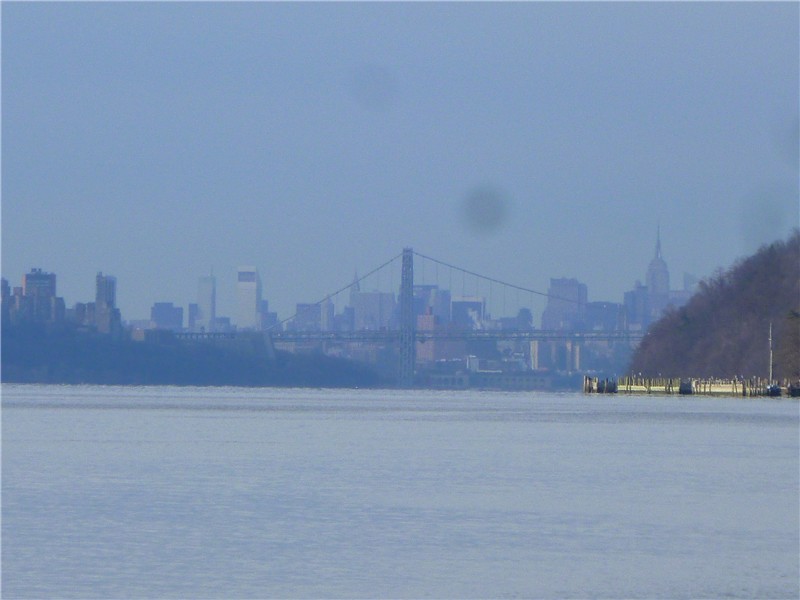
[  2.60]  Rock outcrop with river views
[  3.75]  At railroad tracks, turn right on orange/blue just before culvert
[  4.00]  Cross wooden bridge
[  4.15]  Left on orange as blue goes straight, ford Tucquan Creek
[  4.25]  Sharp left turn on orange as blue comes in from right and joins trail as blue/orange
[  4.45]  Keep straight on blue when orange/blue turns right
[  4.75]  At railroad tracks turn left, cross culvert, orange trail forks to the left, take right orange fork uphill
[  5.55]  Trail joins woods road briefly then leaves to right
[  5.90]  Keep right at split
[  6.00]  Rock outcrop overlook
[  6.15]  Pinnacle overlook; go beyond yellow barriers and stay left on yellow/white when orange/yellow goes right
[  6.40]  Keep straight on yellow when white goes left
     (OR left on white to left on orange/blue back to parking lot)
[  6.55]  When yellow makes sharp right towards orange, keep left on unmarked woods road
[  6.60]  When woods road makes sharp left turn, turn right on unmarked trail through cable cut to intersection with orange trail; left on orange
[  6.75]  Right on orange at intersection with unmarked
[  6.90]  At bottom of rock steps, right on blue when orange/blue goes left; left at railroad tracks,
[  6.95]  Go left of closed bridge to rock hop over Kelly's Run; continue following blue trail which is old paved road (closed to traffic)
[  7.40]  Trail goes left leaving paved road at two yellow barriers; benches on left
[  7.85]  Left at corn field; follow blue blazes on posts over mowed grass path
[  8.20]  Leave corn field on woods road; keep straight on blue when red goes left
[  8.45]  Power cut
[  8.60]  Power cut; head towards yellow barrier with ball field on left
[  8.75]  Back at parking lot

Sunday, March 27, 2011

Palisades Interstate Park, NJ and NY (Bombay Hook - Giant Stairs)


ABOUT THE PARK:  Palisades Interstate Park

DIRECTIONS:
GPS Coordinates for Park Headquarters Parking: 40.953333, -73.920545

View Larger Map

TRAIL MAP:
NY/NJ Trail Conference Hudson Palisades Trails Maps 108 and 109

HIKE DISTANCE:
9 miles - this hike is a combination of two hikes starting at the Park Headquarters in Alpine:
     8 miles - Bombay Hook (Forest View Hike) - NJ Palisades Park
     3 miles - The Giant Stairs - NJ Palisades Park
or
     6 miles - Forest View/Closter Dock Trail Loop - NY/NJ Trail Conference
     4.5 miles - Giant Stairs/Long Path Loop - NY/NJ Trail Conference

HIKE DESCRIPTION:
Start the hike by heading south along the road from the park headquarters. After a very short distance, the aqua-blazed Long Park veers left away from the road.
In a quarter mile the Long Path veers right through a tunnel.  Turn left and switchback down on the orange-blazed Closter Dock Trail.
At .65 mile turn left on the white-blazed Shore Trail.
Stairs branching off the trail to the left and right are worth exploring.
Stairs to the right led to a dynamite storage bunker in the 1930's
Yonkers, NY across the Hudson River.
Around 1 mile the trail splits. The white-blazed Shore Trail goes right, the unmarked Upper Trail goes left. They converge back together in about .7 mile; for this hike I took the Upper Trail.
Looking down on the Shore Trail below from the Upper Trail.
Back on the white-blazed Shore Trail after the Upper Trail joins back in.
Turn around for a view of New York City and the George Washington Bridge.
Cliffs to the left - the return route is along the tops of the cliffs.
Forest View - picnic area and boat basin abandoned after World War II due to decline in visitors.
The Giant Stairs begin at the 3 mile mark. Do not underestimate the warnings. It is VERY slow going and if you have a dog along plan on it taking twice as long as that.  The actual rock scrambles are about 1/2 mile long - took me over an hour to do it with the dog.  It's challenging to find placement for two feet and you have to find additional placement for 4 paws!
After Giant Stairs, a grand entrance to New York State:
The Tappanzee Bridge will come into view then Peanut Leap Cascade.
Peanut Leap Cascade
The white-blazed shore trail ascends up steps along the cascade to the aqua-blazed Long Path.
The Long Path continues to ascend up stone steps.
The steps bring you to views from the top of the cliffs.
New Jersey Boundary Monument
Women's Federation Monument
View from unmarked trail.
1891 Rock Carving
Waterfall from the top down (much more impressive in real life).

HIKE SUMMARY:
[  .25]  Left on orange when LP goes right through tunnel; switchback down
[  .65]  At end of orange, left on white (sign says Forest View 2.3 miles)
[  .75]  Steps up to the left to old dynamite bunker from 1930's; cross waterfalls
[  .80]  Steps down to river on right to Cape Flyaway dock ruins (small fisherman's hamlet from 19th and early 20th centuries)
[  .90]  Second set of steps down to Cape Flyaway dock ruins
[ 1.05]  At split left on unmarked trail when white goes right (can go either way)
[ 1.55]  Cross bridge
[ 1.75]  Upper Trail merges back together with Shore Trail coming in from right; turn around for view of GW bridge
[ 2.70]  Keep straight on white shore trail when blue/white trail goes left
[ 3.00]  Beginning of Giant Stairs
[ 3.45]  Break in rock scramble
[ 3.60]  More rock scramble
[ 3.65]  End of rock scramble; trail smooths out; through chain link gate into New York
[ 4.05]  Peanut Leap Cascade; trail ascends next to cascade
[ 4.10]  Trail turns sharply left up stairs (WRONG WAY painted on tree straight ahead)
[ 4.35]  White trail ends; turn left on aqua-blazed Long Path and cross bridge
[ 4.50]  Aqua trail turns left and ascends stone steps
[ 4.65]  Through gate in chain link fence, border monument straight ahead along fence
[ 4.70]  At T intersection, turn left on aqua-blazed trail (unmarked)
[ 4.75]  At split take left ford; teal blaze on tree short distance ahead
[ 5.15]  Left on old concrete road to State Line Lookout; retrace
[ 5.80]  Left on "F" trail/aqua-blazed trail (would have seen on right heading towards State Line Lookout)
[ 6.00]  Aqua trail turns left but turn markers hard to see on post
[ 6.25]  At intersection turn left on "A"/aqua where "B" goes straight
[ 6.30]  Cross over road
[ 6.45]  Descend steps; cross bridge; keep right on aqua and blue/white combined as blue/white goes left
[ 6.65]  Women's Federation Monument (castle)
[ 6.75]  Aqua-blazed Long Path goes straight, turn left on unmarked trail then continue along wire barrier to views
[ 6.85]  At T-intersection turn left on gravel road
[ 7.25]  At overlook on rock outcrop rock carving from 1891; continue and merge on to aqua-blazed long path coming in from right
[ 8.20]  Cross over bridge; left on unmarked just past bridge to top of waterfall; retrace
[ 8.25]  Continue left on aqua-blazed Long Path
[ 8.30]  Side trail to left over old concrete bridge to view
[ 8.55]  Cross over bridge
[ 9.00]  Palisades Park HQ parking lot

Sunday, March 20, 2011

Jacobsburg Environmental Education Center, PA


ABOUT THE PARK:  Jacobsburg Environmental Education Center - Pennsylvania DCNR

DIRECTIONS:
GPS Coordinates 40.782687, -75.292917

View Larger Map
Popular park - this lot was almost full by early afternoon.  There are other smaller gravel lots around the park that are not as heavily used.

TRAIL MAP:
Jacobsburg EEC Trail Map - Pennsylvania DCR
The route for this hike shown in pink.

HIKE DISTANCE:
8.4 miles

HIKE DESCRIPTION:
The orange Henrys Woods Trail is the only trail in the park other than the yellow trail around Boulton Historic Site that is for hiking only.  The other trails are multi-use and are heavily used by mountain bikers and equestrians.  I found all mountain bikers to be very courteous and excellent about announcing their presence.  I only saw one group of horses during the entire hike but watch where you step - there is ample evidence that many horse hoofs have pounded these trails.

The hike starts across the bridge from the parking to the lower level of the Henrys Woods Trail through hemlock forests along Bushkill Creek.
Bridge from parking lot to Henrys' Woods Trail, restrooms on left across bridge.
The red-blazed Jacobsburg Trail, then the yellow/green-blazed Sober's Run Connector Trail bring you over to the western section of the park.

The green-blazed Sober's Run Loop Trail is a wide rail trail sort of path which forms a loop around the western section, part of which parallels Sober's Run.
The red/green-blazed Explorer Trail provides footpaths through the woods and along Bushkill Creek.

It is necessary to walk a very short distance along a paved road with traffic in order to form a loop without backtracking and missing an important section of the park.  In the picture below, just around the bend to the left is a gravel parking lot.  After walking through the parking lot, a trail continues on the other side of the road.
From the blue-blazed Homestead Trail, which is mostly a woods road except for an unmarked footpath section, you can look to your left to see Blue Mountain where the Appalachian Trail runs along the ridge.
A yellow-blazed trail loops through the Boulton Historic Site which focuses on the Henry Family and their small arms industry, which played a key role in the American Industrial Revolution.
The final par of the hike, the upper level of the orange-blazed Henrys Woods Trail which travels just below the ridge up above the Bushkill River gorge.


HIKE SUMMARY:
[  0.00]  From parking lot cross bridge (restrooms on left) then turn right on the orange Henrys Woods Trail
[  0.30]  Keep right at fork
[  0.80]  Left on red trail
[  1.05]  Cross Belfast Road; red barn on right
[  1.15]  Keep straight at intersection
[  1.25]  Right at intersection, cross bridge; stay left at split
[  1.35]  Veer right at "Danger Quarry Area" sign
[  1.55]  Keep left on red trail as a trail joins in from the right
[  1.65]  Keep left as a trail leaves to the right
[  1.75]  Power cut
[  1.80]  Keep left at split
[  1.90]  Cross bridge then immediately turn right yellow/green; cross smaller bridge
[  2.10]  Keep right at fork; cross State Park Road
[  2.35]  Cross Jacobsburg Road
[  2.60]  Cross Belfast Road
[  2.75]  Turn right at intersection on yellow/green (goes straight also but ends at Bushkill Creek with no crossing)
[  2.90]  Power cut
[  3.00]  Left over bridge
[  3.10]  Walk past kiosk and turn left on green trail
[  3.30]  Straight on green at power cut when green goes right
[  3.50]  Straight on green where yellow/green comes in from left (goes to Bushkill Creek with no crossing)
[  3.70]  Turn right on red/green at power cut (intersection unmarked) and proceed uphill
[  3.75]  Keep right at fork (marker on tree ahead - first red/green marker seen)
[  4.20]  Turn left on green
[  4.60]  Veer left on unmarked trail where green trail goes right
[  4.75]  Keep right at unmarked intersection
[  4.80]  Right on green trail few steps then left on mowed grass trail
[  4.85]  Left on red/green trail (unmarked at turn) along Bushkill Creek towards old abutment; keep straight
[  5.00]  Cross over small bridge, keep straight uphill towards split rail fence when another trail goes left; at split rail fence, turn right and follow creek
[  5.10]  Keep straight when mowed trail comes in from left; power cut
[  5.15]  Turn right at bridge and cross over; turn left on red/green running parallel to Sobers Run on the left
[  5.55]  At T intersection, turn right
[  5.90]  Turn left at fork; cross Belfast Road, turn right and walk on road across bridge; veer left through gravel parking lot
[  6.10]  At end of parking lot turn right to cross Belfast Road to unmarked trail
[  6.15]  At power cut turn right on blue trail
[  6.30]  Blue trail veers sharply left away from road; at top of hill turn left on foot trail (trail not on map) while blue trail goes right
[  6.65]  Right at fork where woods road comes in from left (not on map)
[  6.75]  Keep straight when trail comes in from left (not on map)
[  6.80]  Keep straight on blue trail (woods road) when unmarked foot trail (post saying no horses, no bikes only, trail not on map) goes left
[  7.20]  At intersection keep left on blue trail (woods road)
[  7.25]  Danger sign at orange trail intersection; turn right on orange/blue trail
[  7.35]  Keep right on yellow/blue trail where large bridge is to the left; turn left at old barn on yellow trail and follow around historical area back to barn
[  7.65]  Back at barn, left on blue/yellow trail
[  7.75]  Straight on orange when yellow goes right over bridge
[  7.80]  Right on orange at danger sign
[  8.25]  Descend steps; pass amphitheater on left
[  8.40]  Parking lot