Showing posts with label PA State Game Lands 110. Show all posts

Monday, January 2, 2012

Appalachian Trail, PA: Tom Lowe Trail, Eagle's Nest, Sand Spring


ABOUT THE PARK:
The BMECC Section of The Appalachian Trail - Blue Mountain Eagle Climbing Club
Out on the Trail - The Reading Eagle

DIRECTIONS:
GPS Coordinates 40.537671, -76.123345

View Larger Map
Parking on either side of road just before gate.

TRAIL MAPS:
PA Appalachian Trail Map Sec. 1-6: Delaware Water Gap to Swatara Gap - Keystone Trails Association

HIKE DISTANCES:
Tom Lowe Trail - AT - Eagle's Nest - Eagle's Nest Shelter - Sand Spring: 11 miles
Tom Lowe Trail - AT - Eagle's Nest - Sand Spring:  9 miles
Tom Lowe Trail - Sand Spring:  5 miles

APPALACHIAN TRAIL SECTION HIKING:
TrailHeadFinder.com - AT section miles 1191.9 to 1193.6

THE HIKE:
First rock hop crossing over Northkill Creek.
Several more creek crossings along the way.
The orange-blazed Tom Lowe Trail ascends a gorge through hemlock forests.
A tricky creek crossing in the gorge - the logs are slippery so finding a rock hop a little up stream seems to work better.
Climb up out of the gorge steeply on rocks.
At the top, the last part of the Tom Lowe Trail is flat.
The Tom Lowe Trail ends at Sand Spring.  Left on the blue-blazed Sand Spring Trail leads to the Appalachian Trail.  Right on the Sand Spring Trail returns to the parking lot.
The Appalachian Trail leads to the Eagle's Nest Trail which is almost flat until the end just before the overlook.
Rock scramble to Eagle's Nest Overlook.
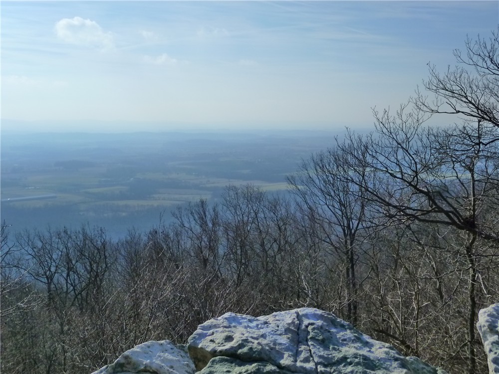
View south from Eagle's Nest Overlook.
A service road which is used for snowmobiling from January 15 through April 1and runs parallel to the Appalachian Trail can be taken as an alternate route to the Eagle's Nest Shelter.
Blue-blazed side trail off the Appalachian Trail towards the Eagle's Nest Shelter and a view north.
Eagle's Nest Shelter
Continue a short distance beyond the shelter to the end of the blue trail for a view north.
The Sand Spring Trail is very rocky and full of roots for a while.
The Sand Spring Trail follows along the spring-fed creek and crosses over several times.
Waterfalls along the Sand Spring Trail.

HIKE SUMMARY:
[  0.00]  Walk back along the road the way you drove in to the start of the orange-blazed Tom Lowe Memorial Trail.  If trailhead is inaccessible due to blow down, continue along the road until you can cut over as trail runs between road and Northkill Creek
[  0.20]  Rock hop over Northkill Creek
[  1.30]  Trail turn right on woods road
[  1.35]  Keep straight towards clearing (old gravel quarry) when woods road goes right
[  1.50]  Cross creek and be careful to follow orange trail to left when, faded white blaze trail goes straight
[  1.60]  Trail makes sharp right turn at old Tom Lowe sign on tree (If you keep straight here, trail becomes difficult to follow even though there are orange blazes but they are sloppy orange blazes, not the neatly painted blazes of the correct trail.)
[  2.00]  Trail goes slightly uphill through gorge
[  2.30]  Cross over creek either on logs or find rock hop
[  2.60]  Trail veers to right away from gorge and begins to ascend steeply on rocks
[  2.80]  Trail flattens out at top of climb
[  3.10]  Tom Lowe Trail ends at Sand Spring; turn left on blue-blazed Sand Spring Trail
[  3.30]  Left on white-blazed Appalachian Trail when blue Sand Spring Trail goes straight
[  4.15]  Stretch of very rocky trail
[  4.40]  Turn left on blue-blazed Eagles Nest Trail
[  5.40]  Rock scramble to Eagles Nest Overlook; retrace
[  6.40]  Straight on blue Eagles Nest Trail when white-blazed Appalachian Trail crosses over
[  6.70]  Turn right on gravel service road with sporadic orange diamond blazes
[  7.20]  Keep straight on gravel service road when blue-blazed Sand Spring Trail goes right
[  7.70]  Turn left on white-blazed Appalachian Trail
[  7.80]  Left on blue-blazed trail to Eagles Nest Shelter
[  8.00]  Trail turn sharply left downhill to cross stream then turns right uphill
[  8.10]  Continue beyond Eagles Nest Shelter following blue blazes downhill to view; retrace
[  8.50]  Turn right on white-blazed Appalachian Trail
[  8.60]  Keep straight on Appalachian Trail crossing over gravel service road
[  9.20]  Left on blue-blazed Sand Spring Trail
[  9.35]  At Sand Spring keep straight on the blue-blazed Sand Spring Trail when orange-blazed Tom Lowe Trail goes right
[  9.60]  Keep left on blue when unmarked goes right, several creek crossings
[  9.80]  Trail veers away from creek and becomes less rocky, gradually descends
[10.85]  Turn right on gravel service road
[ 11.00]  Back at parking

Monday, November 21, 2011

Appalachian Trail: Auburn Overlook to Port Clinton, PA with Schuylkill River Trail


ABOUT THE PARK:
Appalachian Trail - Keystone Trails Association
Schuylkill RIver Trail - Schuylkill River Trail Association

DIRECTIONS:
GPS Coordinates 40.5521 -76.0542

View Larger Map
Turn on the gravel road at the State Game Lands sign then proceed to a large parking lot on the left.
If the gates are open you can drive all the way to the top and shave 2.4 miles and a huge climb up off the hike but this is one-way so you will be driving out a different way and missing a great view.
Parking at the top just before the Appalachian Trail and Auburn Overlook a short distance to the left before the barrier.

TRAIL MAPS:
PA Appalachian Trail Map Sec. 1-6: Delaware Water Gap to Swatara Gap - Keystone Trails Association (3rd item down to purchase map)
PA State Game Lands 110 - Pennsylvania Game Commission (Auburn Overlook in wrong place on map)
Schuylkill River Trail Hamburg to Pottsville Section - Schuylkill River Trail Association

HIKE DISTANCE:
Full hike with additional section of Schuylkill River trail:  13.6 miles
Full hike:  10.8 miles
Hike from upper parking lot:  8.4 miles
Deduct .9 mile if not detouring into Port Clinton

APPALACHIAN TRAIL SECTION HIKING:
TrailHeadFinder.com - AT section miles 1200.2 to 1202.7

THE HIKE:
NOTE:  Most of this hike is on state game lands and should only be hiked on Sundays from September through February.  Hunting is currently not allowed on Sundays in Pennsylvania.
From the parking lot walk up the gravel road which will start to switchback up more steeply.
Near the top, nice views to the east.  The view is better on the way down when the sun is not directly ahead.
At the top turn right towards a wooden barrier (alternate parking) then just before the barrier turn left on a short unmarked trail which will cross over the white-blazed Appalachian Trail and go directly to the Auburn Overlook.
Auburn Overlook with views of Weiser State Forest, Stony Creek and the Schuylkill River.
From the overlook, turn around back to the AT, turn left and make note of the sign on the right which will remind you where to turn on the unmarked trail coming back at the end of the hike.
The Appalachian Trail follows the ridge of the Blue Mountain with views all around when foliage is not present.
The small town of Port Clinton comes into view as the AT descends, very steeply at times.
The AT comes out on the multi-use Schuylkill River trail.  Continue to the left on this cinder trail or follow the AT to the right for a .9 mile loop of Port Clinton.
Continuing right on the AT, a very short but very steep set of stone steps lead down to the railroad tracks.
Carefully cross live railroad tracks over to picnic tables along the Schuylkill River.
View of the Schuylkill River at the picnic tables.
Watching trains from the picnic tables at the river.
Continue on the AT into town following arrows and blazes.
When the AT turns right just beyond the fire station, keep straight to busy Route 61 and turn left. 
Walk 1 block along Route 61 to the Clinton Peanut Shop, an old-fashioned candy store...
... with a ton of snack choices.
Loop around the block from the candy store to avoid Route 61 and meet back up with the Appalachian Trail.  Follow over the railroad tracks and up the steep stone steps back to the Schuylkill River Trail.
Follow the Schuylkill River Trail to the right where the live tracks run a level below and the Schuylkill River a level below that.
After a little over 2 miles turn left into the Stony Creek Parking Lot.
Or continue straight on the rail trail for 1.4 miles to the end of the trail as it exists today with a break spot and the river flowing below.  From this point retrace back to the Stony Creek parking lot.
Walk straight through the parking lot to a short footpath then left on a woods road which will start to ascend, steeply at times
When the woods road ends at a pipeline cut, turn left and ascend very steeply but be sure to stop and turn around for great views in the opposite direction nearing the top.
After the pipeline cut turns left and flattens out along a ridge, the ridge of the Appalachian Trail is visible to the right.
After just a little incline, the pipeline cut meets up with the AT just before descending steeply.  Turn right on the AT and when meeting up with the woods road, that can be taken the rest of the way to give weary feet a break from the jagged rocks of the AT.
Take the gravel road back down the switchbacks to the lower parking lot.  The views are clearer now with the sun out of the way.

HIKE SUMMARY:
[  0.00]    Continue up gravel road beyond gate
[  0.80]    View to the east along switchback
[  1.20]    Veer right towards upper parking; turn left before wooden barrier on path, cross AT to Auburn Overlook
[  1.30]    From Auburn Overlook retrace to AT, turn left on AT
[  1.35]    AT joins woods road briefly before leaving to the left
[  1.65]    AT crosses over woods road
[  2.20]    First pipeline cut (will be coming in from the left at end of hike)
[  2.60]    Second pipline cut
[  3.30]    Cross unmarked trail
[  3.40]    Turn left briefly on cinder trail then follow AT to the right down steep steps; cross live tracks and follow AT over two bridges
[  3.70]    AT turns right after fire station; continue straight to end and turn left to follow along the left side of Route 61
[  4.90]    Port Clinton Peanut Shop; continue to end of block, turn left 1 block, turn left back to AT, right on AT over bridges then railraod tracks
[  4.25]    Ascend steep steps and turn right on Schuylkill River Trail
[  6.60]    Turn left into Stony Creek parking lot, walk straight through to path then left on woods road
               (Continue straight for 2.8 mile out and back to end of Schuylkill River Trail)
[  7.20]    Woods road ends at pipeline cut, turn left and go uphill very steeply
[  7.30]    Pipeline cut turns left and levels out following ridge
[  8.60]    After short incline turn right on AT at top before pipeline descends
[  9.20]    Turn left on woods road for smoother walking surface (or continue on AT to Auburn Overlook Sign)
[  9.50]    AT joins woods road briefly before leaving to the right
[  9.60]    Walk through upper parking then turn left on gravel road to switchback down
[10.00]    View to the east along switchback
[10.80]    Back at lower parking lot