Appalachian Trail in Maryland - Appalachian Trail Conservancy
Gathland State Park - Maryland Department of Natural Resources
South Mountain State Park - Maryland Department of Natural Resources
Appalachian Trail - Maryland Department of Natural Resources
C&O Canal National Historical Park - National Park Service
DIRECTIONS:
GPS Coordinates 39.40613, -77.63921
 |
| One of two parking lots at Gathland State Park. |
TRAIL MAPS:
Maps 5 & 6 - Appalachian Trail Across Maryland and the Catoctin Trail - Potomac Appalachian Trail Club
HIKE DISTANCE: 15.4 miles
THE HIKE:
In early October 2019 I had done a similar 2-day hiking trip on the Appalachian Trail in Virginia and Dolly Sods in West Virginia. I really enjoyed that trip so it was almost a last minute decision to do something similar again. This year it was a section of Appalachian Trail in Maryland, overnighting in a motel in Winchester, Virginia then North Fork Mountain in West Virginia the second day.
 |
| Ruins and historical buildings in Gathland State Park. |
 |
| From the parking lot the Appalachian Trail crosses Gapland Road ... |
 |
| ... follows the park road a short distance ... |
 |
| ... then turns left just before a second parking lot. |
 |
| I had read that this is one of the easiest sections of the Appalachian Trail and it is - mostly smooth woods road all along the ridge of South Mountain. |
 |
| Caveney Wilderness Memorial |
 |
| There is a wall of rocks along the actual ridge on the left. |
 |
| Turning left to check out the shelter. We'd be using that bench for a break on the way back. |
 |
| It's one of the swankiest shelters I have seen. |
 |
| Back to the AT heading south. |
 |
| I had grabbed someone's track off of Gaia where it showed them taking a trail down to a road. I figured this would be a nice alternative rather than a straight out and back on the AT. |
 |
| Green is the track I loaded to my phone leaving the AT. |
 |
| It starts out as a faint path (so it is being used somewhat) |
 |
| then opens up into a clear woods road that descends fairly gently down the mountain. |
 |
| At the bottom the gated woods road ends at Weverton Road where we turned left. |
 |
| There is nothing posted so it looks like this is all park land. |
 |
| There is a country store just after turning on Weverton Road where you can grab a soda or a beer! |
 |
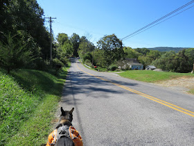
| It's not a bad road walk at all and there is some nice scenery. |
 |
| For the longest time there was no road work. Turns out it would be way at the other end of the 1.4 mile road walk. |
 |
| And there is it. Would they let us pass? I spoke to the woman in the truck and she said it was fine, to just keep to the left of the trucks since they were working on the right. |
 |
| Shortly after these ruins we turned right on Weverton Cliffs Road ... |
 |
| ... then left into the park and ride lot which is where people park to get to Weverton Cliffs. I wanted to scout it out as a potential parking spot for a future hike. |
 |
| At the far end of the lot several side trails lead right to the Appalachian Trail where we turned right to head down to the Potomac River. |
 |
| Going under Route 340. |
 |
| The trail comes out on a road where there is parking along the side - another parking alternative. |
 |
| The AT crosses railroad tracks and just our luck we had to wait for a train, the LONGEST train ever. We waiting at least 20 minutes. |
 |
| Finally able to cross over. |
 |
| Straight ahead ... |
 |
| C&O Canal Towpath |
 |
| Just after crossing over Israel Creek ... |
 |
| ... there is an unmarked trail on the left. |
 |
| It's a well-defined footpath that leads to ... |
 |
| ... nice views of the Potomac River. |
 |
| I don't know that I have even seen an old growth tree this huge before. |
 |
| A right on to the C&O Canal Towpath then left to retrace back to the park and drive lot. |
 |
| At the park and ride lot we stayed on the AT ... |
 |
| ... crossing the road to continue up to Weverton Cliffs. |
 |
| The trail switchbacks up steeply at times. |
 |
| At the top, right on the blue-blazed trail to Weverton Cliffs. |
 |
| At the cliffs, I parked Brodie off to the side and ventured out myself first. You have to go out on the jagged rocks to get to views. |
 |
| To the right is Harpers Ferry. |
 |
| Two eagles were circling. |
 |
| The Potomac River from Weverton Cliffs. |
 |
| Another couple was there so I retrieved Brodie and we took pictures for one another. At first Brodie tried to climb into my lap. |
 |
| That's more like it. |
 |
| Leaving Weverton Cliffs on the blue trail ... |
 |
| ... to continue north on the AT. |
 |
| About a mile or so out from Weverton Cliffs it's actually pretty rocky but smooths out again nearing the point where I had left the AT earlier in the hike. |
 |
| Retracing on smoother trail all the way back to Gathland State Park. |


No comments:
Post a Comment