ABOUT THE PARK:
Kokiwanee Nature Preserve - ACRES Land Trust
DIRECTIONS:
GPS Coordinates 40.819359, -85.683047
Kokiwanee Nature Preserve Trail Guide - ACRES Land Trust
HIKE DISTANCE: 2.7 miles
THE HIKE:
Heading back to New Jersey from Missouri on travel day 1, hike 1 of 2.
 |
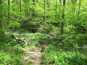
| Straight ahead from the parking lot is the wide main trail. We immediately turned right on ... |
 |
| ... the Mossy Heights Trail. |
 |
| Starting to catch glimpses of the Salamonie River down below. |
 |
| At the bottom, right on the River Trail. |
 |
| Following closely along the Salamonie River. |
 |
| Frog Falls with a trickle of water coming down. |
 |
| Salamonie River |
 |
| Heading back along the River Trail. |
 |
| On to another waterfall. |
 |
| Climbing up steeply out of the ravine but this time with some steps. |
 |
| Kissing Falls |
 |
| Crossing over the top of Kissing Falls. |
 |
| A few more dogwood blooms here. They were all gone in Missouri. |
 |
| At Fawn Lake the trail to the left is a wide, mowed path. We took the footpath to the right ... |
 |
| ... which turned out to be unused and becoming overgrown. |
 |
| We worked our way around back to the main trail ... |
 |
| ... back to the parking lot. Now a short drive in the car across the river to Salamonie State Forest. |


No comments:
Post a Comment