ABOUT THE PARK:
American Legion and Peoples State Forests - Connecticut DEEP
DIRECTIONS:
GPS Coordinates 41.942530, -73007598
 |
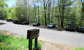
| Parking across from trail head along East River Road. |
TRAIL MAP:
American Legion and Peoples State Forests Trail Map - Connecticut DEEP
HIKE DISTANCE: 7 miles
Hiked together with:
American Legion State Forest - Henry Buck Trail - 2 miles
American Legion State Forest - Turkey Vulture Ledges Trail - .8 miles
THE HIKE:
I was hesitant to start on the Falls Cut Off Trail because I had read things like: Hardest trail in Connecticut, not for those afraid of heights, 90% grade... Other than my fear of heights I was worried about getting Brodie up rock scrambles. He is not a fan and keeps wanting to go back down. But thought I would give it a try and I am glad I did. Despite what I read, it is not that bad. I only had to help Brodie up once.
 |
| Eastern Phoebe at the Farmington River |
 |
| Crossing East River Road to the trail head. |
 |
| The sign pertains to the trail we would be returning on. |
 |
| Just a short distance in, left on the blue/red Falls Cut Off Trail. |
 |
| It starts off smooth enough ... |
 |
| ... then suddenly becomes rocky. |
 |
| Going up. |
 |
| There are a lot of steps built in with rock slabs. The trail goes up right next to the falls, sometimes the falls are flowing down the trail. |
 |
| Looking back down the trail. |
 |
| Crossing the falls. |
 |
| Nearing the top of the falls. |
 |
| At the top, we turned left on the blue/yellow Jessie Gerard Trail. |
 |
| Black and White Warbler |
 |
| Still a little bit of climbing ... |
 |
| ... to an overlook to the south. |
 |
| Farmington River down below. |
 |
| Across the Farmington River I can see the old bridge abutments where the Henry Buck Trail is that we would be hiking later. |
 |
| Continuing on through gorgeous forests. |
 |
| Coming up on another ... |
 |
| ... overlook to the north. |
 |
| At the Jessie Gerard Trail sign, right on the park road a short distance to ... |
 |
| ... left on the Charles Pack Trail which is also blue/yellow. |
 |
| At the stop sign at the park road I did not see any turn blazes but it is a left turn over the bridge then a right just the other side of the bridge. |
 |
| Looking back at the bridge we just crossed over. |
 |
| Just before this bridge over Beaver Brook, right at the post to ... |
 |
| ... the green Pond Trail. |
 |
| It's a short distance to a nice overlook at the pond. |
 |
| Heading back and crossing the bridge. |
 |
| At this post, a left on the blue/orange Agnes Bowen Trail. |
 |
| Right on the blue Robert Ross Trail. |
 |
| Back at the Jessie Gerard Trail, left to switchback down steeply. |
 |
| Almost at the bottom, the Lighthouse Village Cemetery. |
 |
| Unmarked field stones that designate graves. |
 |
| Back at the parking lot for lunch and a break before heading across the Farmington River to the American Legion State Forest. |
 |
| But before leaving, a short path from the parking area down to Farmington River. |


I think my dream retirement car is a Toyota Forerunner. I've never driven in one. On one of our Virginia trips, we were in a packed parking lot. We saw a trail maintainer with a Forerunner do an amazing parking job backing up a rocky hill, so that he could get a spot. My car could never do that!
ReplyDeleteThat looks like a nice hike. I'm aiming for 5 miles with my pup at this point. Maybe in 3 months he'll be ready for a 7 mile hike. But, he doesn't walk nicely on a leash. It is torture doing so. We are working on it....
ReplyDeleteBrodie isn't bad on a leash but that little tug at the end of the flexi when we are going downhill or rock hopping over water has almost done me in a couple of times. The most difficult thing to teach him was to WAIT until I tell him he can go to his bowl to eat. I would literally have to drag him back across the room and hold him. He's a pro at that now. I have put the WAIT command into practice while hiking so he stops and doesn't pull at the end giving me time to catch up. After 1.5 years, he is finally starting to get it on hikes.
Delete