ABOUT THE PARK:
Nassau Trail - High Bridge Borough, NJ
DIRECTIONS:
GPS Coordinates 40.66309, -74.88150
TRAIL MAPS:
Nassau Trail - High Bridge Borough, NJ (not very accurate or useful)
HIKE DISTANCE: 5.8 miles
THE HIKE:
 |
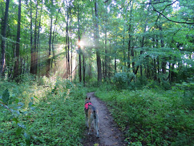
| An overnight storm had just moved out, it was 100% humidity, and the sun beams put on quite a show. |
 |
| Trails branch off from the Nassau Trail but I stayed with the Nassau Trail intending to take one of the other trails back. |
 |
| The Nassau Trail is blazed in yellow. No other trails are blazed. |
 |
| Coming up on Nassau Road ... |
 |
| ... at a second parking lot. |
 |
| The yellow-blazed Nassau Trail actually turns left and follows Nassau Road to who knows where (nothing on maps) but a trail continues on the other side of Nassau Road. |
 |
| This is call the Connector Trail. |
 |
| Last night's raindrops coming down in buckets with every wind gust. |
 |
| The Connector Trail starts to switch back on itself as mountain bike trails tend to do. You get in a lot of mileage in a little bit of space. |
 |
| A contemporary cairn. |
 |
| Shawnee modeling a battery, a pool slide and an old barn all in one picture. |
 |
| We left the Connector Trail on the Rich Woods Trail which is not on the map. |
 |
| The Rich Woods Trail is all squiggly switchbacks. |
 |
| Finally, a straight stretch... |
 |
| ... to boxes where trail maintenance equipment is most likely store, just beyond which... |
 |
| ... is a trail to a field. The map shows a perimeter trail. I did not see this, only tire marks straight across the field but looked like houses on the other side. |
 |
| A bench at the field. |
 |
| And way, way over across the field, a cat. |
 |
| I did not know it until I uploaded my track but I should have taken the Springside Loop because that is actually the trail with the least squiggles but I did not know it at the time. So we squiggled and switchbacked on. |
 |
| Heading back on that straight stretch. |
 |
| There were so many birds to be heard but not seen. Even the robins were elusive but I managed to get one. |
 |
| This is where we came out of the Rich Woods Trail on the left so keeping right for the return route, |
 |
| Turkey Vulture |
 |
| That brought us right back to the Connector Trail which we retraced on. |
 |
| Crossing back over Nassau Road. |
 |
| We turned left on the Flat Lands Trail where the Nassau Trail went straight. |
 |
| Eastern Towhee |
 |
| Coming off of the Flat Lands Trail which again was a squiggly, switchbacking trail. |
 |
| Back on the Nassau Trail. The Nassau Trail is the only trail we were on that does not squiggle in on itself. |
 |
| Tomorrow, July 11, 2016, is Shawnee's Gotcha Day. Fifteen years ago on July 11, 2001 I sprung her from the Newark, NJ animal shelter. |


Congratulations and Happy Gotcha Day to Shawnee! 15 God Bless Her! She's such a great companion. Your pictures are beautiful as always especially the spider web and the bird. I give you both credit for hiking in the heat and humidity. Thanks for sharing! Joanne from Denville, NJ
ReplyDeleteThanks, Joanne!
DeleteHappy Birthday to Shawnee. Everyone should be lucky enough to have such a wonderful companion. Thank you for all your hard work that lets me enjoy the hikes and scenery from my laptop. It is a great enjoyment. Bill from Clifton, NJ
ReplyDeleteThanks, Bill! I consider myself very lucky to have had her as a companion all these years and the fact that she is still going is a huge bonus.
DeleteDaniela
Happy Gotcha Day! We will have to check out this trail- very close to us- I never knew it was there!!
ReplyDeleteThanks! It's very pretty in those woods. This time of year you can barely see the homes nearby so it feels more remote than it actually is.
DeleteDaniela
Happy 15th Gotcha Day to Shawnee! I hope to be still trucking along at her age... and she makes it looks so easy!
ReplyDelete--Dawn
Thanks, Dawn! Shawnee is something like 93 in people years so if we are still mobile without walkers by then we will be doing good!
DeleteDaniela
Hello Daniela, Thank you for the review, I am more of a mountain biker than hiker thanks to some sore knees, so I was interested in checking out this trail after reading about it here. Your review was very accurate lol, the maps are not much help but we had a fun day riding! Thanks again, and Happy gotcha day to Shawnee.
ReplyDeleteThanks! I would think that on a mountain bike it would be more efficient to ride around figuring out the map than on foot! I remember seeing where I needed to be but not able to get there until I squiggled around some more, LOL. But still good exercise.
DeleteDaniela