ABOUT THE PARK:
Swartswood State Park - New Jersey Department of Environmental Protection
DIRECTIONS:
GPS Coordinates 41.072747, -74.819451
View Larger Map
TRAIL MAP:
.jpg) |
| There are some maps that look like this one and they are not accurate. The Spring Lake Trail description on the web site is not accurate either. |
.jpg) |
| I colored in the trails on a picture of the kiosk map to make it more clear. It's a better map and makes more sense with colors. Black is the paved Duck Pond Trail. |
My track won't make much sense because I did some looping around trying to figure out the trails and make sense of them.
Swartswood State Park, NJ at EveryTrail
HIKE DISTANCE: 6 miles
Hiked together with
Swartswood State Park - Grist Mill Trail
THE HIKE:
.jpg) |
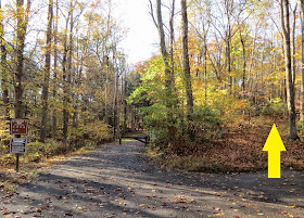
| The yellow-blazed trail starts to the right of the paved Duck Pond Trail. |
.jpg) |
| The yellow trail ends at the other end of the paved Duck Pond Trail. Cross straight over to the start of the white-blazed trail. |
.jpg) |
| A bridge over nothing to nowhere. |
.jpg) |
| A crow in waterless Duck Pond. |
.jpg) |
| A VERY confused dog wondering where the water is. |
.jpg) |
| Bone dry Duck Pond. |
.jpg) |
| Standing in Duck Pond. |
.jpg) |
| The white trail ends at a T-intersection where the red trail goes either way. Left goes to the campground, right goes to Spring Lake. |
.jpg) |
| Some water in Spring Lake! |
.jpg) |
| Spring Lake |
.jpg) |
| Frog Pond, a grassy area sometimes with water. |
.jpg) |
| An old trail marker. |
.jpg) |
| Back at the bridge over nothing to nowhere. |
.jpg) |
| Returning on the Duck Pond Trail. |
.jpg) |
| Meeting some other hikers in the parking lot. |
.jpg)
.jpg)
.jpg)
.jpg)
.jpg)
.jpg)
.jpg)
.jpg)
.jpg)
.jpg)
.jpg)
.jpg)
.jpg)
.jpg)
.jpg)
.jpg)
.jpg)


.jpg)
.jpg)
.jpg)
.jpg)
.jpg)
.jpg)
.jpg)
.jpg)
.jpg)
.jpg)
No comments:
Post a Comment