ABOUT THE PARK:
Fahnestock State Park - NY State Office of Parks, Recreation and Historic Preservation
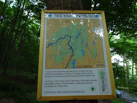
Hudson Trail - Friends of the Hudson Trail
DIRECTIONS:
GPS Coordinates 41.415255,-73.853618
View Larger Map
 |
| There is room for one, maybe two cars on the side when the pavement ends. The gravel road straight ahead, the return route, is very rutted and washed out so cars can't get through. The red-blazed Candlewood Hill Trail starts on the right a few steps in. |
TRAIL MAP:
East Hudson Trail Map #103 - New York New Jersey Trail Conference
HIKE DISTANCE: 8.10 miles
THE HIKE:
To "Anonymous" who gave me the info on these trails when I
hiked in Fahnestock almost a year ago - thanks! As you indicated, these trails are awesome!
.jpg) |
| A few steps in on the gravel road to the three red discs on the tree on the right. |
.jpg) |
| The Hudson Trail follows the route of the Candlewood Hill Trail. |
.jpg) |
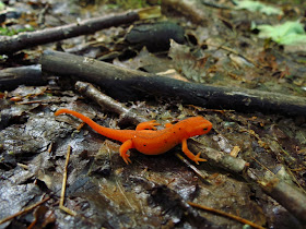
| The first red eft I have seen this year. |
.jpg) |
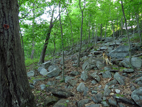
| The Candlewood Hill Trail becomes rocky near the top. |
.jpg) |
| Some partial views. |
.jpg) |
| Eastern Towhee |
.jpg) |
| Not sure what this arrow means but ignore it and stay with the red markers. I thought maybe it went to a view but it doesn't until you meet back up with the red trail then you have to backtrack on the red trail to see the views of the Hudson Vally. So best to stay with the red trail. |
.jpg) |
| Looking to the east - I believe that is part of Oscawana Lake. |
.jpg) |
| Looking to the west. |
.jpg) |
| Southwest towards the Hudson Valley. |
.jpg) |
| Close-up of the Hudson River and the Indian Point nuclear plant. |
.jpg) |
| Mountain Laurel is almost ready to pop. |
.jpg) |
| Sunk Mine Road |
.jpg) |
| View from side trail off of Sunk Mine Road. |
.jpg) |
| Remember this gravel road on the left before the guardrail - it's the gravel part of Bell Hollow Road back to the car. |
.jpg) |
| It's a pretty walk and although Sunk Mine Road is open to traffic, there shouldn't be but a car or two. |
.jpg) |
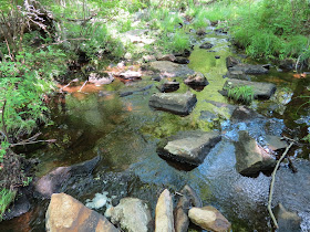
| Canopus Creek from Sunk Mine Road. |
.jpg) |
| On the Appalachian Trail... |
.jpg) |
| ... to a lake with geese. |
.jpg) |
| LOTS of geese! |
.jpg) |
| Some scrambling on the AT up to the ridge. |
.jpg) |
| A few Mountain Laurel flowers have opened. |
.jpg) |
| Bloom of a tulip poplar tree, per HenoftheWood, thanks! |
.jpg) |
| Millipede |
.jpg) |
| The blue 3 Lakes Trail. |
.jpg) |
| View of Hidden Lake from the 3 Lakes Trail. |
.jpg) |
| Beaver Lodge |
.jpg) |
| View of Hidden Lake from a side trail just before the turn for the yellow Old Mine Railbed Trail. |
.jpg) |
| A resident of Hidden Lake. |
.jpg) |
| Damselfly |
.jpg) |
| The yellow Old Mine Railbed Trail starts on the right. |
.jpg) |
| Rock hop over the Hidden Lake outlet. |
.jpg) |
| What's holding the water back. |
.jpg) |
| Hidden Lake on the right, yellow turns left. |
.jpg) |
| Nice break spot with a view of ... |
.jpg) |
| Hidden Lake |
.jpg) |
| The trail becomes a grassy railbed, easy walking and a nice breeze on a very hot day. |
.jpg) |
| John Allen Pond from a short side trail. |
.jpg) |
| John Allen Pond from a side trail off of Sunk Mine Road |
.jpg) |
| A resident of John Allen Pond. |
.jpg) |
| Broken dam at John Allen Pond. |
.jpg) |
| Sunk Mine Road heading towards a swamp. |
.jpg) |
| Dragonfly |
.jpg) |
| Ruins on the right off of Sunk Mine Road. |
.jpg) |
| Turn right after the guardrail on Bell Hollow Road. |
.jpg) |
| Bell Hollow Road |
.jpg) |
| Back at the beginning of the hike and the car. |
HIKE SUMMARY:
[0.00] Take red-blazed Candlewood Hill Trail on right just after Bell Hollow Road turns to gravel
[0.70] Keep left following red markers when white arrow painted on rock points to the right
[0.75] Views to the east then views to the west before descending
[1.10] Turn left on gravel Sunk Mine Road
[1.30] Just before Sunk Mine Road turns right, unmarked woods road on left leads to view; retrace and continue on Sunk Mine Road
[1.70] Note woods road on left just before guardrail which is Bell Hollow Road, the return route; continue on Sunk Mine Road
[2.15] Sunk Mine Road crosses Canopus Creek; side trails lead down to creek on either side of bridge
[2.40] Right on the white-blazed Appalachian Trail just before top of hill
[2.45] Rock hop over creek with pond on left and waterfalls on right
[3.50] At intersection with large cairn, turn left on blue 3 Lakes Trail but markers won't be visible until after turn
[3.90] View of Hidden Lake on right
[4.05] At T-intersection turn right for short woods road to Hidden Lake view; retrace
[4.15] Back at T-intersection, turn right in just a few steps on yellow-blazed Old Mine Railbed Trail
[4.20] Rock hop over creek
[4.35] At two cairns, Hidden Lake view on right, turn left to continue on yellow trail now grassy railbed
[4.75] Straight on yellow when red Charcoal Burner Trail crosses over
[5.15] Yellow leaves the railbed as footpath to the left
[5.45] Short side trail on left to John Allen Pond
[5.80] Turn left on Sunk Mine Road
[5.85] Stay on Sunk Mine Road when blue 3 Lake Trail leaves to the right
[6.00] Turn left on side trail to John Allen Pond; continue to the right to the dam
[6.10] Take unmarked path from dam which runs into blue 3 Lakes Trail, turn right then left on Sunk Mine Road
[6.35] Ruins on the right
[6.45] Woods road leave to the left
[6.80] Keep straight on Sunk Mine Road when the white-blazed AT crosses over
[7.50] After guardrail turn right on woods road
[8.10] Back at car
.jpg)
.jpg)
.jpg)
.jpg)
.jpg)
.jpg)
.jpg)
.jpg)
.jpg)
.jpg)
.jpg)
.jpg)
.jpg)
.jpg)
.jpg)
.jpg)
.jpg)
.jpg)
.jpg)
.jpg)
.jpg)
.jpg)
.jpg)
.jpg)
.jpg)
.jpg)
.jpg)
.jpg)
.jpg)
.jpg)
.jpg)
.jpg)
.jpg)
.jpg)
.jpg)
.jpg)
.jpg)
.jpg)
.jpg)
.jpg)
.jpg)
.jpg)
.jpg)
.jpg)
.jpg)
.jpg)

.jpg)
.jpg)

.jpg)
.jpg)
.jpg)
.jpg)
.jpg)
.jpg)
.jpg)
.jpg)
.jpg)
.jpg)
.jpg)
.jpg)
.jpg)
Dunno if you're curious, but the big yellow flower under the mountain laurel that has started to open is the bloom of a tulip poplar tree.
ReplyDeleteLove your blog!
Yes! THANKS! I was wondering what kind of tree it was from - knew it was from a tree, just not what kind.
DeleteDaniela
As always great descriptions and photos! I especially like the Eastern Towhee!
ReplyDeleteThanks! I couldn't believe the Towhee was sitting out in the open like that - what luck!
DeleteDaniela
What a beautiful park of Fahnestock State Park, NY - Candlewood Hill and Old Mine Railbed .Many nice scenery into the park.
ReplyDeleteLakeview Lodge bed and breakfast gidgegannup