ABOUT THE PARK:
Cushetunk Mountain Nature Preserve - Hunterdon County, NJ
Cushetunk Mountain Trail - Readington Township, NJ
DIRECTIONS:
GPS Coordinates to parking at Pickell Park: 40.607862, -74.778427
View Larger Map
 |
| The southern trail head for the Cushetunk Mountain Trail is located in Pickell Park. |
 |
| Large parking area at Pickell Park. |
TRAIL MAP:
Cushetunk Mountain Preserve Trail Map - Hunterdon County, NJ
HIKE DISTANCE:
8.20 miles with 6.30 mile option
THE HIKE:
 |
| Facing the ball field, turn right and walk towards the kiosk which designates the beginning of the Cushetunk Mountain Trail. |
 |
| Follow the paved path between the ball field and the fence. |
 |
| Looking across the ballfield... |
 |
| Cushetunk Mountain Trail blaze (called Readington Connector Trail on the map) |
 |
| At the far corner of the ball field, the trail exits to the right as a gravel path into the former Vislocky Farm Open Space. |
 |
| Cushetunk Mountain from one of the Vislocky Farm fields. |
 |
| Lots of fall wildflowers along the trail this time of year. |
 | |
| A yellow trail detours through more farm fields... |
 |
| ... and crosses a creek at an old dam before meeting back up with the blue trail. |
 |
| The blue trail crosses through a power cut where a second yellow side trail (not on the map) merges back in. |
 |
| The blue trail then ascends steeply to a white-blazed trail which leads to... |
 |
| ... seasonal/partial views of Round Valley Reservoir. |
 |
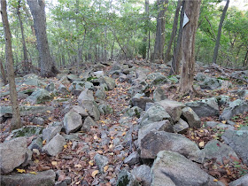
| The unmarked trail meets back up with the white-blazed Ridge Trail which continues along the ridge over a few rugged rock scrambles. |
 |
| More seasonal/partial views of Round Valley Reservoir along the way. |
 |
| When the white trail leaves the ridge to the right, a red-blazed trail to the left leads down to... |
 |
| Round Valley Reservoir |
 |
| Continuing to the right, a green-blazed trail follows close to the shore... |
 |
| ... with lots of nice reservoir views. |
 |
| The green trail veers away from the reservoir at a cairn shortly before a chain link fence and becomes overgrown at times as it switchbacks up the mountain. |
 |
| The green trail ends at an unmarked woods road where you turn right. |
 |
| A nice open view of the reservoir from the woods road along the ridge. |
 |
| The woods road fizzles out into a foot path and red blazes begin to appear just before meeting back up with the white Ridge Trail. |
 |
| The white trail descends steeply to a parking lot in a power cut which leads to... |
 |
| ... the yellow-blazed Scout Trail through a very pretty forest. |
 |
| The blue trail ascends steeply before heading back to Pickell Park. |
HIKE SUMMARY:
[ 0.00] Facing the ball field, turn right and walk towards the kiosk then follow the blue diamond markers along the chain link fence
[ 0.15] At the corner of the paved path, veer right on gravel path into farm field; keep right
[ 0.25] Jog right then left then right on to tree lined woods road between farm fields
[ 0.40] Turn right on yellow then right again at field (no turn marker)
[ 0.55] Exit field downhill into the woods
[ 0.60] Rock hop creek at old dam
[ 0.75] Right on blue when yellow ends
[ 0.80] Rock hop over creek
[ 0.90] Straight on blue into power cut when yellow (not on map) goes right
[ 1.05] Straight on blue when yellow (not on map) comes in from right; blue leaves power cut to the left uphill into woods
[ 1.40] Left on white when blue goes right
[ 1.60] White blazes stop at season view; continue on unmarked foot path along preserve boundary
[ 2.10] Unmarked trail ends at trail closure sign when white comes in from the right; keep left on white around large downed tree trunk and continue along ridge
[ 2.70] At T-intersection turn left on red; keep left at fork a few steps ahead when red also goes right (return route)
*** for 6.35 mile version, turn right on white and pick up from [ 4.60 ] ***
[ 3.00] Keep right at fork on unmarked when red goes left
[ 3.05] At Round Valley Reservoir, turn right on green
[ 3.70] At large cairn, green trail turns sharply right and starts uphill (overgrown section)
[ 3.85] Turn right on unblazed woods road
[ 4.10] Open view of reservoir from woods road; woods road becomes foot path soon after this point
[ 4.50] Red blazes start to appear
[ 4.60] At T-intersection turn left; after a few steps white comes in from the right, keep straight on white (Parking Lot Trail)
[ 5.15] Turn right into power cut at parking area
[ 5.20] Turn right on yellow trail (Scout Trail); keep straight at fork
[ 5.70] Keep right at fork
[ 6.00] Right on white Readington Connector Trail when yellow ends
[ 6.30] Turn left on blue trail
[ 6.90] Turn left on blue when white goes uphill to the right
[ 7.30] Blue trail goes through power cut
[ 7.35] Turn left on yellow (not on map) when blue continues straight in power cut
[ 7.50] Turn left on blue when yellow ends
[ 7.60] Continue on blue through farm fields and tree lined woods road
[ 7.70] Keep right at fork
[ 7.80] Straight on blue when yellow goes left
[ 8.05] Enter ball field on gravel path
[ 8.20] Back at parking


This comment has been removed by the author.
ReplyDelete