Wednesday, May 16, 2012

Hanging Rock State Park, NC


ABOUT THE PARK:
Hanging Rock State Park - North Carolina State Parks

DIRECTIONS:
GPS Coordinates 36.394685, -80.266723

View Larger Map
Huge parking lot at the Visitor's Center - this is only half of one side of the lot.

TRAIL MAP:
Hanging Rock State Park Trail Map - North Carolina State Parks

HIKE DISTANCE:  9 miles

PEAK BAGGING:
Moore's Knob - Peakery.com
Balanced Rock - Peakery.com
House Rock - Peakery.com
Wolf Rock - Peakery.com

THE HIKE:
To start the hike, walk out of the parking lot the way you drove in and turn left on the Lake Trail just before the road.
Go around the lake to the left heading towards the beach area where the trails start.
After going through the lake parking lot, head towards the restrooms.
At the restroom building turn left and go up the steps.
Signs are confusing in this area.  Although you are going to Moore's Knob (there were no signs for Moore's Knob where the lookout tower is), you don't want to follow the sign above because that takes you in the opposite direction you need to go in for this hike.  Instead head towards the family campground following the red circle/white circle trail. 
This is the combined Moore's Wall Loop Trail (red circle) and Tory's Den Trail (white circle) that you will be following in a counterclockwise direction.
After rock hopping a creek, the steps begin and there are many, many, many steps.
Watch for little critters on the trail.  This is a red eft.
If you hike in mid-May, you will be distracted from all the steps by the profusion of mountain laurel...
... and rhododendron along the way.
It was truly an explosion of flowers.
Balanced Rock (much larger than it appears in the picture)
The lookout tower, which both my dog and I, with our fear of heights, had no problems climbing. 
View from the base of the lookout tower.
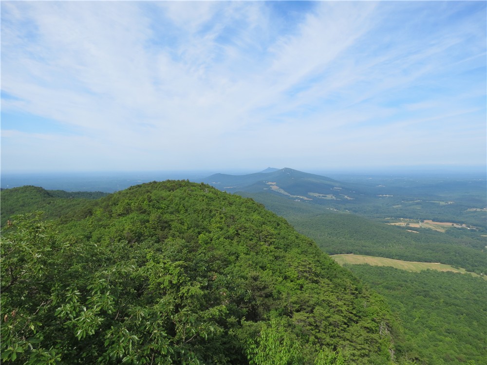
View from the lookout tower.  The farthest mountain in the distance is Pilot Mountain.
Hanging Rock (the final destination for this hike) from the lookout tower.
Interesting rock formations along the trail.
There is a bulge in the belly (?) of this Eastern Milk Snake so he might be laying here quietly digesting.
The blue square Magnolia Springs Trail (no sign with the name, named on map).
A camera shy young black rat snake.  He was moving pretty fast to get away.
White diamond Cook's Wall Trail
House Rock benchmark
View from House Rock
Hanging Rock from House Rock
Wolf Rock was occupied.
View from Wolf Rock
The white diamond Cook's Wall Trail becomes the blue triangle Wolf Rock Trail before ending at the red circle Hanging Rock Overlook Trail, a wide gravel path.
Wooden steps lead up to Hanging Rock...
... as well as stone steps.
Hanging Rock visible up above.
Views from one of the many rock ledges at Hanging Rock.
Moore's Knob with the lookout tower as seen from Hanging Rock
Hanging Rock benchmark

HIKE SUMMARY:
[0.00]    Walk towards parking lot exit, turn left on Lake Trail just before park road
[0.10]    Cross park road and walk between guardrail and lake
[0.15]    Trail veers right away from road then branches 3 ways; take middle paved trail
[0.25]    Come out at parking lot and veer right following sign towards the restrooms
[0.35]    At the restrooms make a sharp left turn up steps towards "Trails" sign; keep right at kiosk then straight on red/white circle trail when blue triangle goes left
[0.60]    At fork keep right on red/white and cross bridge
[0.65]    Take left fork then turn right on red/white towards the family campground
[0.70]    Turn left on red/white up wooden steps
[0.90]    Turn right on road with campsite #40 on right, after short distance follow red/white to left into woods
[1.05]    Turn right down stone steps, cross creek (no red/white markers at the intersection - left goes to campsite; start ascending on stone steps
[1.80]    Bench with view on right
[2.10]    When trail turns left, keep straight at sign to lookout tower; after a few steps turn right to Balanced Rock, retrace and continue to tower
[2.20]    Lookout tower; retrace
[2.30]    At bottom of steps at Lookout Tower sign, turn right to continue on red/white trail
[2.35]    Several trails branch off, keep following red and white circles
[3.70]    Keep left on red when white leaves to the right towards Tory's Den, now following only red circles
[4.30]    Turn right on blue square Magnolia Springs Trail (no sign with trail name) towards Cook's Wall when red turns left (turn left to stay on red for shorter hike, .9 miles to lake parking)
[4.50]    Keep right when short trail to Magolia Springs veers left
[4.80]    Right on white diamond Cook's Wall Trail
[5.10]    At intersection turn left to House Rock when right goes to Cook's Wall (trail sign is in an odd place); after House Rock, retrace on white diamond
[5.40]    Straight on white diamond trail when blue square trail goes left
[5.85]    Keep straight when blue trail leaves left to lake; trail is now blue triangle Wolf's Rock Trail
[6.00]    Wolf Rock on right
[6.95]    Come out on to wide gravel path and turn right towards Hanging Rock
[7.70]    Hanging Rock; retrace
[9.00]    Visitor Center parking lot

Tuesday, May 15, 2012

Fairy Stone State Park, VA - Stuart's Knob


ABOUT THE PARK:
Fairy Stone State Park - Virginia Department of Conservation and Recreation

DIRECTIONS:
GPS Coordinates 36.798622, -80.116830

View Larger Map

TRAIL MAP:
Fairy Stone State Park Trail Guide - Virginia State Parks 

HIKE DISTANCE:  4.4 miles

PEAK BAGGING:
Stuart's Knob - Peakery.com

THE HIKE:
Before leaving for the hike, a visitor at the cabin.  Pictures are blurry because they were taken through the screen of the enclosed porch.  This is a Northern Flicker.
Same bird, different angle.
At the trail head, an adult male Common Whitetail dragonfly.
The Stuart's Knob trails pass several old mines.
There were several huge blowdowns from the storms the day before.
Beach Overlook
The red-blazed Lower Stuart's Knob Trail.
Bull Mountain Overlook on the Lower Stuart's Knob Trail
The blue-blazed Whiskey Run Trail
I heard chainsaws while hiking and could not believe the trails were already being cleared by the park staff.  Sure enough, we ran right into them on the job.  Thanks guys!
The blowdown from the beginning of the hike as we were finishing.

HIKE SUMMARY:
[0.00]    Take trail to right of kiosk at benches; after a few steps turn left on the yellow trail
[0.15]    Turn left on yellow-blazed Iron Mine Trail; pass mine on right as trail veers left
[0.35]    Make sharp right turn on yellow Iron Mine Trail when blue-blazed Whiskey Run Trail goes straight at Beach Overlook
[0.40]    Side trail on right to bench
[0.45]    Turn left on orange-blazed Upper Stuart's Knob Trail
[0.65]    Turn left on red-blazed Lower Stuart's Knob Trail
[0.75]    Turn left on side trail to Bull Mountain Overlook
[0.80]    Bull Mountain Overlook; retrace
[0.85]    Back at intersection, keep straight/left on red-blazed Lower Stuart's Knob Trail
[1.10]    Turn right on yellow-blazed Iron Mine Trail
[1.25]    Keep left on yellow Iron Mine Trail when orange-blazed Upper Stuart's Knob Trail goes right
[1.35]    At beach overlook turn right on blue-blazed Whiskey Run Trail when yellow Iron Mine goes left
[1.70]    Old rock quarry on left
[2.35]    Mine on right
[2.80]    At T-intersection turn right on yellow-blazed Iron Mine Trail
[2.85]    Turn left on Iron Mine Spur Trail when yellow continues straight
[2.95]    Mine at end of spur trail; retrace
[3.05]    Back at yellow Iron Mine trail turn left
[3.35]    Turn right on orange-blazed Upper Stuart's Knob Trail
[3.55]    Keep left on orange Upper Stuart's Knob Trail when red-blazed Lower Stuart's Knob Trail goes right
[3.80]    Left on orange Upper Stuart's Knob Trail when red Lower Stuart's Knob Trail goes right
[4.00]    Right on yellow-blazed Iron Mine Trail
[4.05]    Side trail on left to bench, keep straight
[4.10]    Beach overlook; turn left on yellow Iron Mine Trail when blue-blazed Whiskey Run Trail goes right
[4.30]    Yellow trail veers right with mine on left, after few steps turn left to parking when yellow continues straight
[4.40]    Back at parking lot

Sunday, May 13, 2012

Blue Ridge Parkway, VA - Rock Castle Gorge


ABOUT THE PARK:
Rocky Knob/Rock Castle Gorge Trails - Virginia Birding and Wildlife Trails
Rocky Knob Trails - Virtual Blue Ridge

DIRECTIONS:
Where this hike generally starts at the higher elevation of the Blue Ridge Parkway, I wanted to get the steepest climb out of the way first so I started low in the gorge.  These directions are for that parking area.
GPS Coordinates 36.807732, -80.331023

View Larger Map
Parking for 4 cars on the left (2 on either side) and additional parking to the right all the way to the dead end.

TRAIL MAP:
Rocky Knob Trails - National Park Service

HIKE DISTANCE:
Everything says this hike is 10.8 miles although I measured it out at 11.3 miles with the first third and last third of the hike jiving with given mileage - something was different along the Blue Ridge Parkway section - the difference is probably from circling around cows and crossing over the Blue Ridge Parkway for views on the other side.

PEAK BAGGING:
Rocky Knob - Peakery.com
Grassy Knoll - Peakery.com

THE HIKE:
From the parking area, cross the barrier and bridge and continue straight on the fire road.
Make a sharp right turn on the green-blazed. Rock Castle Gorge Trail.
The trail starts out very easy along the creek through beautiful forests.
During mid-May an explosion of wildflowers throughout most of this hike.
The trail will start to climb more steeply.
And more steeply.
After crossing a challenging blowdown (you have to climb over the top of the huge tree trunk that slants down into the gorge so you keep sliding down the trunk while trying to get over it) the trail becomes intensely steep for a bit.  After passing a bench on the right, things smooth out and it becomes a stroll in the park.
The trail ascends more gently through pastures along the Blue Ridge Parkway.  Posts mark the way.
An interesting tree growing out of a rock in the mountaintop meadow.
There were many cows in the pastures we hiked through.
The cow on the right was standing in the middle of the trail and had no intention of moving so we made a wide circle around her and she kept her eye on us.
There will be several stiles to cross - some with steps like this...
... and a couple of walk-through stiles
The trail traverses The Saddle at the Blue Ridge Parkway.
On the opposite side of the Blue Ridge Parkway from The Saddle overlook, Buffalo Mountain.
An old shelter from when the Appalachian Trail used to pass this way before being rerouted.
View from the old AT shelter.
View from Rocky Knob
View from the Grassy Knoll
Starting the descent back into the gorge.
Descending through Catawba Rhododendrom
Going down is easier than coming up was.
Passing through Bare Rocks.
Old fireplace and chimney in the woods.
Cascades in Rock Castle Creek
The trail becomes an old woods road following along the creek with several bridge crossings.
The Austin House, built in 1916, privately owned.
Final stretch through a campground.
Driving back to the cabin at Fairy Stone State Park I saw a bird sitting in the middle of the highway and she did not fly away when I passed her.  There was no traffic so I put on my flashers, backed up, jumped out and scooped her up.  I held in my hand the Virginia State Bird.  It appeared as though she had been clipped by a car and was dazed.
Back at Fairy Stone State Park I was consulting with the park rangers over what to do with her when she started protesting at being held.  I opened my hand and she flew away and landed in the parking lot.  She would not let the rangers catch her so that was a very good sign that she was coming around.  She flew into a fire wood box and we decided that was a good place for her to rest and hopefully take off when she was ready. 

HIKE SUMMARY:
[0.00]    From parking cross barrier and bridge, continue straight on fire road
[0.10]    Make sharp right turn on to green-blazed Rock Castle Gorge Trail
[0.50]    Trail becomes steeper
[1.25]    Cross over huge blowdown; trail becomes much steeper
[1.40]    Trails levels out some and beyond bench on right becomes very smooth and level
[2.00]    Cross two bridges
[2.80]    Rock hop over creek
[3.00]    Cross fence on stile
[3.15]    Rocky Knob Campground on right other side of Blue Ridge Parkway
[3.70]    Leave cow pasture via walk through stile
[3.90]    Saddle Overlook
[4.00]    Keep left at fork - no blazes through this area which goes over Rocky Knob
[4.15]    Former Appalachian Trail shelter from before the AT was relocated; continue other side of shelter following ledge when other unmarked trails go right towards the parkway; top of incline is Rocky Knob
[4.40]    Green blazes start again
[4.65]    Turn left at T-intersection
[5.05]    Rock Castle Gorge Overlook
[5.40]    Keep left when a trail goes up steps to right
[5.45]    Twelve O'Clock Knob; trail now blazed both green and blue
[5.55]    Straight on green/blue when unmarked comes in from right
[6.05]    Cross fence on stile
[6.40]    Grassy Knoll; just beyond bench keep left on green when blue leaves to the right
[7.10]    Cross fence on stile
[7.75]    Rock hop over creek
[8.30]    Trail goes over boulders of Bare Rocks
[8.65]    Old chimney on left
[8.70]    Cross bridge
[8.75]    Turn left on woods road at T-intersection
[9.50]    Cross bridge
[9.65]    Cross bridge and rock hop creek
[9.90]    Austin house, built in 1916 on right (privately owned)
[10.10]    Cross bridge
[10.90]    Campground
[11.20]    Keep straight when Rock Castle Gorge Trail goes left
[11.30]    Back at parking