Sunday, July 4, 2010

Splitrock Reservoir/Farny State Park (Rockaway, NJ)

SPLIT ROCK ROAD PARKING REOPENED: http://www.dailyrecord.com/article/20100804/COMMUNITIES/100803073/1005/NEWS01/Split-Rock-Reservoir-compromise--Rockaway-Twp.-to-enforce-rules


ABOUT THE PARK:
Farny State Park - NY/NJ Trail Conference Description
Splitrock Reservoir - Wikipedia
From the Rockaway Township Web Site:

Splitrock Reservoir – The reservoir and surrounding land is owned by the City of Jersey City and the public may access the water body for fishing and kayaking only from the public access parking area located near the dam. Only Car top watercraft is permitted providing it is launched from the access located at the parking area. Gas powered motors are not permitted. Shoreline fishing is not permitted. Hiking is allowed only on the specific marked trails – other access will be considered trespass and violators will be subject to fine.
TRAIL MAP:
NY/NJ Trail Conference Online Map (north, south and middle sections of the Four Birds Trail)
South and middle maps merged to fit this hike on one page:


DIRECTIONS:
I-287 to exit 43 to north on Fanny Road to Powerville Road, left on Valley Road, eight on Rockaway Valley Road, left on Split Rock Road which turns to gravel, parking lot on right at Reservoir.

The parking lot holds about 25 cars and I got the last spot at 7:15 am on a Saturday so get there early, mostly people there for fishing and kayaking. Do not park along the road. At the end of the hike every single car I passed that was parked along Split Rock Road had been ticketed and the area was being actively patrolled.


HIKE DISTANCE: 10.5 miles if you can manage to follow the trail - my hike ended up being 9 hours and 14 miles due to backtracking because of poorly marked trails.

HIKE DIRECTIONS:
From the parking lot, turn left and walk along Split Rock Road for about .3 miles. At the second power cut, start looking for the blue blaze on a tree to the left going into the woods. The trail is somewhat obstructed by weeds so you will probably miss it if you aren't looking for the blaze on the tree.


For the first couple of miles the blazing is pretty good. Then it gets spotty. You will find clearly marked blazes in two different shades of blue:


Faded out blazes which are very hard to see:


Blazes which have fallen to the ground or no blazes at all:


Another problem was a blaze indicating a turn but no discernible trail to turn on to. After the 4th time of backtracking, going in circles and not being able to find the continuation of the trail, in sheer frustration I cut through the woods towards the reservoir and continued north on Charlottsburg Road which is a dirt road closed to traffic, mostly running along the reservoir.


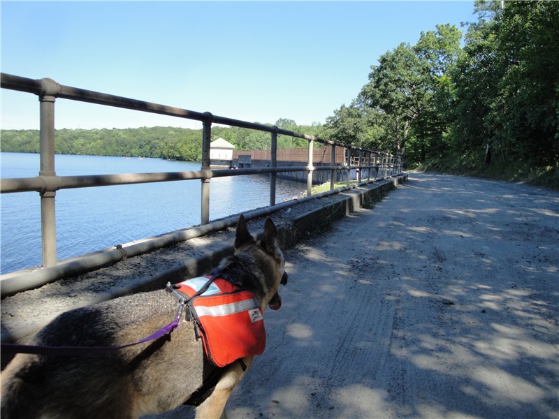
Along this stretch there were some nice views of the reservoir but you had to overlook the broken glass and empty beer cans all along the shore.


I tried to pick up the blue-blazed trail again when it met up with Charlottsburg Road where the McMansions start appearing to the right only to end up in somebody's back yard so I went back and stayed on Charlottsburg Road. There were some faint white blazes and although it was not the right place to run into the white-blazed Four Birds Trail, I followed them only to find the trail terminated at the reservoir.


Continued north along Charlottsburg Road where it becomes a dumping ground for tires, car seats, floor tiles and other assorted garbage until I started noticing orange diamond blazes to the left. I have not seen this trail on maps but really not wanting to hook back up with the blue-blazed trail, I followed to find this trail to be very well-blazed.


The orange-blazed trail terminates right at the white-blazed Four Birds Trail where you turn left.


The white-blazed trail is much better marked than the blue trail. There are a few questionable spots but not near as bad. Others I ran into who hike/run there frequently say they avoid the blue-blazed trail on the east side of the reservoir because it is so difficult to follow. This trail follows along the reservoir for 1 1/2 miles.


Follow the white-blazed trail until it goes downhill steeply to Split Rock Road.


Turn left on Split Rock Road.


Cross the bridge at the dam back to the parking lot on the left just beyond the dam.


To do this hike my recommendation would be to start on the blue-blazed trail but as soon as you start having problems, head on over towards the reservoir to Charlottsburg Road. Don't keep trying and get frustrated like I did - that takes all of the fun out of hiking.

Monday, June 28, 2010

Cumberland Gap National Historical Park, VA-KY-TN and Wilderness Road State Park, VA


ABOUT THE PARK:
Cumberland Gap National Historical Park: National Park Service
Wilderness Road State Park: Virginia Department of Conservation and Recreation

TRAIL MAP:
Cumberland Gap National Historical Park: Online Map
The trails we hiked are indicated in pink:


Wilderness Road State Park: Online Map

DIRECTIONS:
From Hungry Mother State Park 146 miles, about 3 hours
Google Maps is to Cumberland Gap, TN - as you turn off Hwy 58 towards Cumberland Gap shortly after you pass the "Welcome to Tennessee" sign, you will see the Daniel Boone Visitor Information Center almost immediately on the right.
GPS Coordinates: 36 36'05.7 83 39'36.0

View Larger Map


Wilderness Road State Park: You will pass the park on Highway 58 about 8 miles from the Daniel Boone Parking Area on the right.

HIKE DISTANCE:
Cumberland Gap National Historical Park - 9 miles
Wilderness Road State Park - 1 mile

HIKE DIRECTIONS:
From the Daniel Boone parking lot, look for the decking opposite the visitor center. Follow the decking all the way down to the street then walk along the street into the small historic town of Cumberland Gap, TN.


A woman I spoke to later in the hike told me she had breakfast at a restaurant in Cumberland Gap that morning. She was in the area doing some ancestry searching. In that restaurant there were old framed receipts hanging on the wall. She looked up to find three of them that had been signed by her great, great grandfather. A lot of people passed through that town a couple of hundred years ago. Hard telling what you might find.

If you do a little exploring in town, remember the sign you will see for the Iron Furnace as that is where you want to go to get on the hiking trails.


Follow the trail from the Iron Furnace, which is the Tennessee Road, to the intersection of the Wilderness Road where you turn left. (Right will take you back to the Daniel Boone parking lot if you want to do a short loop.)


Here is where I totally messed up. I saw this sign:


And shortly beyond that, this monument which I thought was the Tri-State Peak where the three states came together. I did not find out until later when I looked at the map more closely that you need to continue on the trail past this monument to get to the Tri-State-Peak - this monument is not it!


Even though I missed standing in all three states at one time, our hike did still take us through all of them - Virginia, Tennessee and Kentucky.

From right in the area where the trail is to the Tri-State Peak, you want to take the Harlan Road Trail towards Fort McCook. These trails all come together in what is called the Saddle of the Gap.


You will be crossing over the road which heads to the Pinnacle.


At the Fort McCook parking lot, a trail leads up to a scenic overlook but it was a very foggy day so there was not much of a view.


From the Fort McCook parking lot you will see a sign for the continuation of the Harlan Road Trail but that is not the trail to take from this point. Look along the right side of the parking lot for an unmarked trail which is the Fort McCook Trail to the Pinnacle. If there are cars parked in the lot you might have trouble seeing it if you don't know where to look.


Take the Fort McCook Trail all the way to the Pinnacle. Our views were foggy in the morning so after the hike I drove up to get better pictures since the fog had lifted some. My SUV that gets 26 miles per gallon sucked up 1/8 of a tank of gas climbing that hill - hiking up had been much more energy efficient!


You will see the sign for the Ridge Trail trailhead in the Pinnacle area. Follow the Ridge Trail towards Lewis Hollow.


You'll pass some vistas on the right along the Ridge Trail. Again, when we were there the clouds were very low and covered most of the views.


As you are walking along the ridge, you will have one foot in Kentucky and the other in Virginia:


You start to come down off of the ridge and reach the intersection where you turn right on the Lewis Hollow Trail.


After crossing a bridge you will see Skylight Cave on the left.


At the end of the Lewis Hollow Trail, turn right and walk along the road for a short distance. Watch for the Colson Trail sign on the left. There will be a faint crosswalk in the road and opposite the Colson Trail sign on the right side is where you turn right on the Boone Trail which is unmarked.


The Boone Trail takes you through fragrant wild flower meadows with a view of the mountain ridge you were on earlier.


The Boone Trail brings you to the back of the Daniel Boone Visitor Center.

On the way back to Hungry Mother State Park we stopped at Wildnerness Road State Park where there were some great views of the mountains and the 1 mile Indian Ridge Trail.


For the Indian Ridge Trail parking lot, drive straight through the park past the visitor's center and you will see a sign for the parking lot on the right.


The view is obstructed by foliage in the summer but when the leave are down you should be able to look down from this viewpoint and see the original Wilderness Road which runs through the park:


We would have explored longer but after that last mile, which was our 56th mile of the week, my dog was limping and was ready to call it a day so that was the end of a week of hiking for us.