ABOUT THE PARK:
Forbes State Forest - PA DCNR
Laurel Summit State Park - PA DCNR
Spruce Flats Bog - PA DCNR
 |
| PA DCNR trails are blazed according to usage. |
DIRECTIONS:
GPS Coordinates 40.11843, -79.17620
 |
| Parking at Laurel Summit State Park |
 |
| Laurel Summit State Park is only 6 acres but it serves as parking/trailhead for this hike. |
TRAIL MAP:
Laurel Highlands Trail System - PA DCNR
This is the best map to use. Other maps do not show all of the trails.
HIKE DISTANCE: 8.3 miles
THE HIKE:
 |
| From the far end of the parking lot, the Wolf Rocks Trail. |
 |
| This part of the Wolf Rocks Trail is blazed blue indicating it is a shared use trail for hiking, biking and cross country skiing. |
 |
| At the split, we went left on the Wolf Rocks Loop. |
 |
| This trail is blazed red indicating it is a more narrow and rocker shared use trail. There was an occasional blue blaze also. |
 |
| Where the trail meets back up with the other side of the Wolf Rocks Trail, left to ... |
 |
| ... Wolf Rocks Overlook. |
 |
| Heading back. |
 |
| Now staying left on the Wolf Rocks Trail. |
 |
| There seemed to be some views to the left. |
 |
| There was an unmarked path that left over to Rector Eddie Road so we went to take a look but it wasn't much more than we could see from the trail so back on the Wolf Rocks Trail. |
 |
| At the intersection where the Wolf Rocks Trail meets up with the Wolf Rocks Loop, left on the Spruce Flats Trail. |
 |
| This trail ends at Rector Edie Road where we turned right. |
 |
| A short distance ahead, a parking lot and ... |
 |
| ... the Silvermine Trail which I later determined I could have taken but I was looking at a map that did not show all the trails and at the time did not know this would have connected to where I wanted to go. |
 |
| So continuing along on Rector Edie Road, which was OK because it was easier hiking for a bit. |
 |
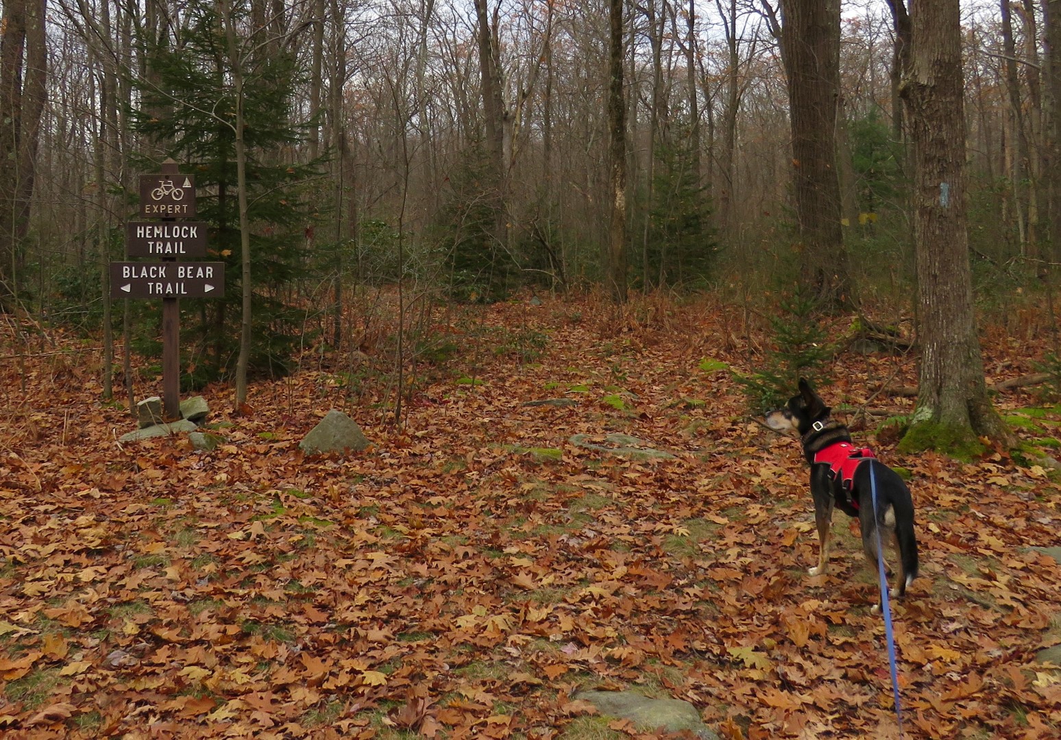
| Then left on the Black Bear Trail. |
 |
| The map I had did not show the Black Bear Trail going to the left or the Hemlock Trail so I pulled out a different map (the one I linked to above) and there were the trails. I could have avoided the gravel road walk but it all worked out. |
 |
| Black Bear Trail |
 |
| Airglow Observatory through the woods. That means I was getting close to the Beam Rocks Trail. |
 |
| A little farther along, a faint footpath to the right towards Laurel Summit road and it was clear with no brambles so that's the was we went because it would cut off an unnecessary chunk of hiking to get to the Bear Rocks Trailhead. |
 |
| Just a short distance to the road and the Beam Rocks parking lot to the left. |
 |
| Taking the Beam Rocks Trail |
 |
| At the first fork, either direction meets back up. |
 |
| At the second fork, left to Beam Rocks. |
 |
| A wind farm in the distance. |
 |
| Under Beam Rocks. |
 |
| Back at that last fork, the right trail, still blazed red, leads down to this yellow-blazed foot traffic only trail which is the Laurel Highlands Trail. We turned right. (red blazes continue to the left) |
 |
| We went from a clear, sunny morning to a cloudy afternoon with some spritzing at this point but fortunately it only lasted a couple of minutes. |
 |
| Laurel Highlands Trail 40 mile marker. |
 |
| We could have taken the Laurel Highlands Trail all the way to just before the park entrance where we parked but it was a little longer, we were getting tired and had another 5 hours to drive so we turned right on Hall Springs Road... |
 |
| ... then crossed over at the intersection to ... |
 |
| ... J E Miller Road then ... |
 |
| ... left on the Picnic Area Trail back to Laurel Summit State Park. |
 |
| It only took 6 hikes in 5 states over 8 days totaling 36.3 miles for Brodie to start lagging. |
 |
| He did get a second wind when we took a short side trip to ... |
 |
| Spruce Flats Bog |
 |
| Now heading back ... |
 |
| ... to the parking lot and the drive home during which Brodie slept soundly the entire ride. |


Once again, you did a great hike, the 2nd of my 5 favorites. The current interpretation of yellow, red and blue is relatively new - this is the first time I've seen it. It must be Governor Wolf's legacy (all trail blazing in PA originates in Harrisburg). You did the hike exactly as I do it. If you haven't already done them, the other 3 of my top 5 are (a) Mountain Streams (partially unmapped-to make a loop), Laurel Mtn (from the ski cabin to Beam Rocks and then cross the road and go back north to Midway Cabin), White Tail Trail (out and back or shuttle), Quebec Run. I know, that's 4 more. There's also the Helldiver Hike (start at SGL 42 by the shooting range, climb up to the LHHT, go left to an unmapped trail leading more or less to the west following the "most used trail"). Go thru the game fence. You will arrive at the 1940-something crash site of a Navy Helldiver aircraft. There is a small memorial there along with the remains of the engine. You can then go back as you came (long) or bushwhack to the bottom of the mountain to a point near your starting point. If you join the Pittsburgh Meetup Hiking Group, you will get access to GPS maps and photos of these hikes. See https://www.wikiloc.com/wikiloc/view.do?id=20973077
ReplyDeleteThanks! I'll keep those in mind when I am passing through that part of PA again.
DeleteDaniela
For Pennsylvania, this doesn't look too rocky!
ReplyDeleteOnly the red-blazed trail was rocky in places but still nothing like what we are used to over here. I was amazed at the flat rocks on the trails we hiked in Missouri versus the pointed rocks we know and love in PA!
Delete